Northwich to Sandbach
![]()
![]() This lovely short route starts by the tourist information centre in Northwich and follows National Cycle Route 5 to Sandbach. Leaving Northwich you follow the River Weaver along the Weaver Valley Cycleway to Winsford. There is then a short stretch along the Shropshire Union Canal towards Middlewich before country roads take you onto Sandbach, finishing by the rail station.
This lovely short route starts by the tourist information centre in Northwich and follows National Cycle Route 5 to Sandbach. Leaving Northwich you follow the River Weaver along the Weaver Valley Cycleway to Winsford. There is then a short stretch along the Shropshire Union Canal towards Middlewich before country roads take you onto Sandbach, finishing by the rail station.
Northwich to Sandbach Ordnance Survey Map  - view and print off detailed OS map
Northwich to Sandbach Open Street Map  - view and print off detailed map
Northwich to Sandbach OS Map  - Mobile GPS OS Map with Location tracking
Northwich to Sandbach Open Street Map  - Mobile GPS Map with Location tracking
Further Information and Other Local Ideas
Just south of Sandbach you can pick up the Wheelock Rail Trail. This popular path is suitable for both walkers and cyclists. It runs for just over a mile between Malkin's Bank and Elworth along a flat surfaced path.
The popular Whitegate Way starts/finishes in Winsford. The shared cycling and walking trail follows a disused railway line north to Cuddington. A car park and the old station can be found at the Winsford end.
Cycle Routes and Walking Routes Nearby
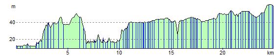
Elevation Profile