Stroud to Gloucester
19.9 miles (32 km)
![]()
![]() Follow National Cycle routes 45 and 41 from Stroud to Gloucester on this fairly easy route. Starting near the train station in Stroud the route soon joins National Cycle Route 45 for an off road stretch to Stonehouse.
Follow National Cycle routes 45 and 41 from Stroud to Gloucester on this fairly easy route. Starting near the train station in Stroud the route soon joins National Cycle Route 45 for an off road stretch to Stonehouse.
You'll then join National Cycle route 41 after crossing the Gloucester and Sharpness Canal. The route turns North East following minor roads with views of the River Severn before finishing with a pleasant stretch along the Gloucester and Sharpness canal taking you into Gloucester town centre.
Stroud to Gloucester Ordnance Survey Map  - view and print off detailed OS map
Stroud to Gloucester Open Street Map  - view and print off detailed map
Stroud to Gloucester OS Map  - Mobile GPS OS Map with Location tracking
Stroud to Gloucester Open Street Map  - Mobile GPS Map with Location tracking
Cycle Routes and Walking Routes Nearby
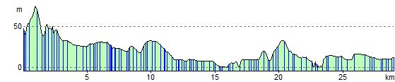
Elevation Profile