Clay Way - Cranfield, Holcott Wood, Brogborough Lake, Astey Wood, Hanger Wood, Stagsden
11.2 miles (18 km)
![]()
![]() A lovely walk or cycle through the Forest of Marston Vale along the West Bedfordshire Clay Ridge. You start at Bromham, on the River Great Ouse, and head to Cranfield, passing through Hanger Wood, Astey Wood and Stagsden as you go.
A lovely walk or cycle through the Forest of Marston Vale along the West Bedfordshire Clay Ridge. You start at Bromham, on the River Great Ouse, and head to Cranfield, passing through Hanger Wood, Astey Wood and Stagsden as you go.
The final section then runs from Cranfield to Ridgmont Railway Station passing Holcott Wood, Brogborough Lake and Brogborough Hill.
There are some terrific views of the Vale, the Ouse Valley and Milton Keynes. The path mainly follows bridleways so is suitable for cyclists with a mountain bike or hybrid.
Please click here for more information
Clay Way Ordnance Survey Map  - view and print off detailed OS map
Clay Way Open Street Map  - view and print off detailed map
Clay Way OS Map  - Mobile GPS OS Map with Location tracking
Clay Way Open Street Map  - Mobile GPS Map with Location tracking
Cycle Routes and Walking Routes Nearby
Photos

River Ouse, Bromham

Brogborough Lake near Lidlington

Stagsden West End
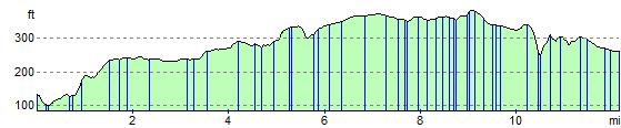
Elevation Profile
GPS Files
GPX File
Clay Way.gpx (On Desktop:Right Click>Save As. On Ipad/Iphone:Click and hold>Download Linked File)NB GPS file for this route only details route start - route is waymarked from there in