Crowdecote Walks
![]()
![]() This Derbyshire based village is a popular starting point for Peak District walks with a number of fine local hill climbs to try. There's also an 18th century packhorse bridge over the River Dove and a noteworthy 16th century pub to relax in after your exercise.
This Derbyshire based village is a popular starting point for Peak District walks with a number of fine local hill climbs to try. There's also an 18th century packhorse bridge over the River Dove and a noteworthy 16th century pub to relax in after your exercise.
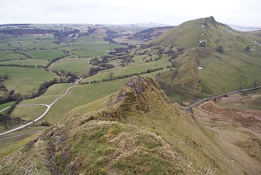
This walk from the village takes you up to two of the local viewpoints at High Wheeldon and Chrome Hill. You'll also visit the neighbouring village of Earl Sterndale on the way.
From the high points there are wonderful views over the Upper Dove Valley area of the Peak District.
To continue your walking around the village you could head east to visit Lathkill Dale or south to the famous stepping stones in glorious Dovedale.
Postcode
SK17 0DB - Please note: Postcode may be approximate for some rural locationsCrowdecote Ordnance Survey Map  - view and print off detailed OS map
Crowdecote Open Street Map  - view and print off detailed map
Crowdecote OS Map  - Mobile GPS OS Map with Location tracking
Crowdecote Open Street Map  - Mobile GPS Map with Location tracking
Walks near Crowdecote
- High Wheeldon - This walk climbs High Wheeldon Hill in the Upper Dove Valley area of the Peak District
- Chrome Hill - This circular walk climbs the beautiful Chrome Hill in the Upper Dove valley area of the Peak District
- Longnor - The village of Longnor is based in a lovely part of the Staffordshire Peak District
- High Peak Trail - This splendid, shared walking and cycle trail follows a disused railway line from Cromford to Dowlow through the beautiful Peak District.
The trail starts near Cromford railway station and climbs through the stunning High Peak area of Derbyshire giving fabulous views of the area.
The trail links with the popular Tissington Trail at High Peak Junction - Poole's Cavern and Buxton Country Park - A walk around Buxton Country Park and a visit to Poole's Cavern - a natural limestone cave used as a lair by an outlaw in the fifteenth century
- Buxton - The popular spa town of Buxton has a number of waymarked trails taking you though this beautiful area of the Peak District
- Three Shires Head - Explore this beautiful section of the Dane Valley and enjoy rivers, old stone bridges and waterfalls on this lovely walk in the Peak District.
Three Shires Head is a point on Axe Edge Moor where the counties of Cheshire, Derbyshire and Staffordshire meet - Hartington - This pretty village is a great base for exploring some of the highlights of the popular Dove Dale area of the Peak District
- Hurdlow - This circular walk explores the area surrounding the hamlet of Hurdlow in the Peak District
- Chelmorton - This circular walk explores the area around the Peak District village of Chelmorton near Buxton in the White Peak
- Hollinsclough - This Peak District village is located in a fine spot for scenic walks in the National Park.
- Solomon's Temple - This circular walk climbs to a splendid viewpoint and folly in Buxton Country Park in Derbyshire.
- Lathkill Dale - Enjoy a splendid riverside walk in the beautiful Lathkill Dale in the Peak District
- Dovedale - The beautiful Dovedale is one of the must see areas in the Peak District
Pubs/Cafes
Back in the village head to the Packhorse Inn for some post walk refreshment. The inn dates back to the 16th century when it served as a stop off point from the packhorse trail from Newcastle Under Lyme to Hassop, near Bakewell. There's a charming old interior and a garden area with fine views of the valley.


