Delamere Way
![]()
![]() Take a walk along the Delamere Way and visit Delamere Forest Park and the Trent and Mersey Canal.
Take a walk along the Delamere Way and visit Delamere Forest Park and the Trent and Mersey Canal.
The path starts in Frodsham and heads south to Delamere Forest with its 2,400 acres of mixed deciduous and evergreen woodland and Blakemere Moss - a lake around 1 km in length. The smaller Hatchmere Lake can also be found in this area. There's a nice waterside pub to visit here.
You then turn north towards Acton Bridge before crossing the River Weaver at Dutton Lock and then the Trent & Mersey Canal shorty after. The final section takes you through Hatton and past Appleton Reservoir before finishing at Stockton Heath in Warrington.
To extend your walking in the area you could try our Sandstone Trail Circular Walk which uses two long distance trail to create a loop from Frodsham.
Delamere Way Ordnance Survey Map  - view and print off detailed OS map
Delamere Way Open Street Map  - view and print off detailed map
Delamere Way OS Map  - Mobile GPS OS Map with Location tracking
Delamere Way Open Street Map  - Mobile GPS Map with Location tracking
Further Information and Other Local Ideas
The trail links up with the Baker Way in Delamere Forest. The easy path will take you to Chester with a pleasant stretch along the Shropshire Union Canal.
Cycle Routes and Walking Routes Nearby
Photos

The Delamere Way at Birch Hill, Manley

The 6th green at Frodsham Golf Club from the Delamere Way. Taken from the Delamere Way footpath, the 6th green at Frodsham Golf Club. Laid on undulating parkland which has many challenging holes that demand accuracy and precision with each shot and offering fantastic panoramic views of the surrounding area, Frodsham Golf Club has a very demanding course to challenge golfers of all standards and capabilities.
Beacon Hill from the Delamere Way. Looking North across the 6th fairway of Frodsham golf course to Beacon Hill, photo taken from the Delamere Way footpath.

Autumn Colour, Delamere Forest. This sector is towards the north-eastern edge of the Forest and includes the bridleway into Norley village.

The Delamere Way at Dutton Park

A summer view of the trail near Frodsham
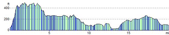
Elevation Profile