Ebor Way
![]()
![]() Follow the Ebor Way from Helmsley to Ilkley on this walk through Yorkshire. The first section runs from Helmsley to York, passing Hovingham and the ruined Sheriff Hutton Castle, before a short section along the River Foss leads you into York. After leaving York following the River Ouse, you head towards Tadcaster where you join the River Wharfe taking you to Boston Spa and Wetherby. Here you continue to Otley, passing the impressive Harewood House which is a major route highlight.
Follow the Ebor Way from Helmsley to Ilkley on this walk through Yorkshire. The first section runs from Helmsley to York, passing Hovingham and the ruined Sheriff Hutton Castle, before a short section along the River Foss leads you into York. After leaving York following the River Ouse, you head towards Tadcaster where you join the River Wharfe taking you to Boston Spa and Wetherby. Here you continue to Otley, passing the impressive Harewood House which is a major route highlight.
The house was built in the 18th century and has wonderful art collections while there is also a Bird Garden and over 100 acres of beautiful gardens to enjoy.
The final section of the walk runs from Otley to Ilkley through Ilkley Moor, passing the famous Cow and Calf Rocks and the historic village of Burley in Wharfedale on the way.
The walk is waymarked with a green and white disc.
Ebor Way Ordnance Survey Map  - view and print off detailed OS map
Ebor Way Open Street Map  - view and print off detailed map
Ebor Way OS Map  - Mobile GPS OS Map with Location tracking
Ebor Way Open Street Map  - Mobile GPS Map with Location tracking
Pubs/Cafes
In the riverside village of Boston Spa you could stop off at the The Stew and Oyster. They do lovely home cooked food and have a fine selection of beers on tap. It's located right next to the car park on the high street at postcode LS23 6BH for your sat navs. The pub is also dog friendly if you have your canine friend with you.
In Hovingham there's the Hovingham Inn. They do a fine Sunday lunch and have an outdoor seating area. You can find them on the Main Street at postcode YO62 4LF for your sat navs. The idyllic village is also worth exploring with a historic Saxon Church, a picturesque cricket pitch by the old Hovingham Hall and a pretty beck running through it..
In Sheriff Hutton there's The Highwayman. They serve good quality dishes which you can enjoy in the lovely garden area. You can find them on The Square at postcode YO60 6QZ. The village is also worth exploring with a Grade I listed 12th century church and a photogenic ruined castle dating from a similar period.
Cycle Routes and Walking Routes Nearby
Photos

View to Mill Holm Plantation from The Ebor Way

Near Bank Side Farm The Long Distance Footpath heading west from the farming complex.

The Ebor and Centenary Ways are long distance paths which share this track as they make their way towards Howthorpe Farm in the distance.

Ebor Way junction near Sproxton. Just east of Sproxton village is the 'dog's leg' where the Ebor Way turns through an acute angle. Both stages of the route are in view here.

Ebor Way Signpost, Harewood Estate. The Ebor Way is a route of 112Km which links the Cleveland Way at Helmsley with the Dales Way at Ilkley. Here is a sign where it comes through Stub House Plantation on the Harewood Estate.

Path at Terrington
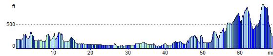
Elevation Profile