River Goyt Walk
![]()
![]() Follow the Goyt Way along the Peak Forest Canal and the River Goyt on this lovely waterside walk through Greater Manchester and Derbyshire.
Follow the Goyt Way along the Peak Forest Canal and the River Goyt on this lovely waterside walk through Greater Manchester and Derbyshire.
The walk starts by Etherow Country Park Lake in Compstall and heads south through Marple and New Mills to Whaley Bridge. The first section through Marple follows the towpath of the Peak Forest Canal, passing pretty locks on the way. You then join the River Goyt to New Mills before picking up the Canal again near Whaley Bridge where the route finishes. The final section through New Mills passes the wonderful Torrs Riverside Park and Millennium Way, a beautiful river gorge with a fabulous 160 metre long walkway elevated over the water.
Goyt Way Ordnance Survey Map  - view and print off detailed OS map
Goyt Way Open Street Map  - view and print off detailed map
*New* - Walks and Cycle Routes Near Me Map - Waymarked Routes and Mountain Bike Trails>>
Goyt Way OS Map  - Mobile GPS OS Map with Location tracking
Goyt Way Open Street Map  - Mobile GPS Map with Location tracking
Pubs/Cafes
After your walk head to the The White Hart pub on Market St in Whaley Bridge (postcode SK23 7HN). It's a popular and friendly pub with a beer garden overlooking the stream.
The Cock is another really good option and can be found on Buxton Road at postcode SK23 7JE. It has a nice interior and a beer garden to relax in during the warmer months.
In Etherow Country Park the on site cafe is a nice place for a pit stop. You can sit outside here and enjoy views over the park's lake with its variety of wildfowl.
In Marple Bridge The Midland is worthy of consideration. The pub is in a lovely spot overlooking the river in the heart of the village. You can sit outside on the balcony and enjoy a meal with a view over the water. They're located close to the train station at 26 Brabyns Brow, SK6 5DT.
Further Information and Other Local Ideas
Near Marple Bridge there's the climb to the Mellor Cross. The religous cross marks the site where John Wesley preached during the 18th century. There are fine views from the elevated position of the site. You could take a detour east from the path around Marple to reach the site.
Near Marple you could take a small detour to explore the historic Chadkirk Country Estate in Romiley. There's a noteworthy 16th century chapel, a little cafe and a walled garden to enjoy here.
For more walking ideas in the area see the Derbyshire Walks, Greater Manchester Walks and Peak District Walks pages.
Cycle Routes and Walking Routes Nearby
Photos

A view of the footpath as it makes its way through Brabyns Park in Marple Bridge.

Following the southern bank of the river on a tree lined path
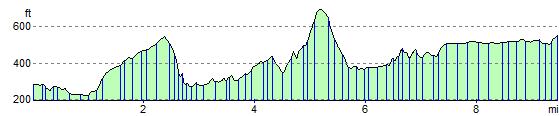
Elevation Profile