Limestone Link Walk Map
![]()
![]() Starting at Cold Ashton in St Catherine's Valley, Gloucestershire follow the Limestone Link from the Cotswolds to the Mendip Hills in Somerset.
Starting at Cold Ashton in St Catherine's Valley, Gloucestershire follow the Limestone Link from the Cotswolds to the Mendip Hills in Somerset.
The walk first heads south towards Batheaston where you join the River Avon and the Kennet and Avon Canal for a lovely waterside stretch to Monkton Coombe. You will also pass near to Little Solsbury Hill, made famous by the Peter Gabriel song 'Solsbury Hill'.
The second section of the path then takes you through the
Mendip Hills with fabulous views of the Chew Valley, Burrington Combe limestoneĀgorge, Dolebury Warren Iron Age Hill Fort, the waterfall at Hallatrow and the final stretch through Burrington common the main highlights.
Limestone Link Ordnance Survey Map  - view and print off detailed OS map
Limestone Link Open Street Map  - view and print off detailed map
*New* - Walks and Cycle Routes Near Me Map - Waymarked Routes and Mountain Bike Trails>>
Limestone Link OS Map  - Mobile GPS OS Map with Location tracking
Limestone Link Open Street Map  - Mobile GPS Map with Location tracking
Pubs/Cafes
In Midford we recommend stopping off at the noteworthy Cross Keys. The pub has an interesting history, dating all the way back to the early 1700s when it began as a coaching house. There's an attractive interior withĀlog fires in the winter and a large beer garden outside in the summer. They have a great menu and are also very dog friendly with water and treats provided for your canine friend. It's also a great place for walkers with many local walking groups that start and end their walks at the inn. You can find the inn just west of the Coombe Down Tunnel at a postcode of BA2 5RZ for your sat navs.
In Monkton Combe there's the Wheelwright's Arms. The building dates back to the 18th century and includes a noteworthy large garden which can seat up to 140 people. They serve a fine Sunday lunch and also provide accommodation if you need to stay over. You can find them on Church Lane with postcode BA2 7HB for your sat navs.
Further Information and Other Local Ideas
Near Bath the path links up with the Two Tunnels Greenway. This shared circular trail explores the area's old railway tunnels on a good surfaced path.
In Somerset the route passes close to a number of pretty lakes including Chew Valley Lake, Litton Reservoir and Blagdon Lake. These are all worth a small detour from the route.
Cycle Routes and Walking Routes Nearby
Photos

Limestone Link footpath. A view looking to the northeast towards a swinging gate on theĀfootpath as it crosses the lane form Combe Hay to Wellow, just north of Combe Hay Bridge.

The path heading towards the eastern edge of Dolebury Warren. Black Down is on the skyline.

ĀHolcombe Swing Bridge, across the Kennet and Avon Canal, near Bathampton, swung open to allow boats to pass through.

Kennet and Avon Canal. Approaching Hardings Bridge, near Henngrove wood
.jpg)
Limestone Link, Doleberrow
The path heading towards the eastern edge of Dolebury Warren. Black Down is on the skyline.
ĀA view looking to the northeast towards a swinging gate on the Limestone LinkĀfootpath as it crosses the lane form Combe Hay to Wellow, just north of Combe Hay Bridge.
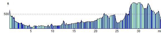
Elevation Profile