Longster Trail
![]()
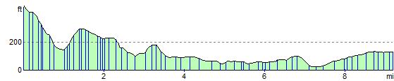
![]() The Longster trail runs from Helsby to Chester via the villages of Great Barrow and Guilden Sutton. The path starts on Helsby Hill with great views of the Cathedrals in Liverpool, Beeston Castle and the mountains of North Wales. You then head south west passing Manley Mere, Great Barrow and Guilden Sutton village. The path is named after Frank Longster, a local man who served as chairman of the Mid-Cheshire Footpath Society during the 1970s.
The Longster trail runs from Helsby to Chester via the villages of Great Barrow and Guilden Sutton. The path starts on Helsby Hill with great views of the Cathedrals in Liverpool, Beeston Castle and the mountains of North Wales. You then head south west passing Manley Mere, Great Barrow and Guilden Sutton village. The path is named after Frank Longster, a local man who served as chairman of the Mid-Cheshire Footpath Society during the 1970s.
Longster Trail Ordnance Survey Map  - view and print off detailed OS map
Longster Trail Open Street Map  - view and print off detailed map
Longster Trail OS Map  - Mobile GPS OS Map with Location tracking
Longster Trail Open Street Map  - Mobile GPS Map with Location tracking
Further Information and Other Local Ideas
Just to the east of the trail around Ashton Hayes you could pick up the Baker Way and follow it to the expansive Delamere Forest near Kelsall. Here you'll find miles of good cycling and walking trails to try.
For more walking ideas in the area see the Cheshire Walks page.
Cycle Routes and Walking Routes Nearby
Photos

Longster Trail Sign near Guilden Sutton. The Mid Cheshire Footpath Society & Parishs Partnership sign for the Trail.

Looking towards Helsby Hill.

As the trail route travels through Guilden Sutton, it reaches roughly the midway point between Chester and Helsby. The building in the centre of the photograph is the local hostelry called The Bird in Hand.

View of the Oxen Bridge on the River Gowy. The trail crosses the river here.

Chester - Fairfield Road bridge. On the disused Chester - Fairfield Road bridge. Chester. On the disused Mickle Trafford railway just east of the Fairfield Road bridge. The rail track is being developed by SusTrans as a cycleway and this part will also soon be the new extension of the Longster Trail running from Guilden Sutton to Blacon. The traffic cones and JCB tracks are a positive indication that SusTrans work was in progress at the time the picture was taken! just east of the Fairfield Road bridge. The rail track is being developed by Sustrans as a cycleway and this part will also soon be the new extension of the Longster Trail running from Guilden Sutton to Blacon. The traffic cones and JCB tracks are a positive indication that Sustrans work was in progress at the time the picture was taken in spring 2008.

Alvanley - path through barley. This is Alvanley footpath 7 - well reinstated through a growing barley crop. The photo is taken looking west towards the Longster Trail, with the Cheshire Plain and the Welsh hills just visible beyond. A scene in which little has changed since more peaceful times. Alvanley village lies further west and Bowling Alley Farm just to the north.

Mouldsworth; view across the Gowy plain from the trail (Mouldsworth footpath 5) across the to the distant refineries at Stanlow. Dairying predominates in this part of the county. Mouldsworth is divided between the higher land on the edge of the Sandstone Ridge and the low-lying meadows of the Gowy plain to the west.

Chester - Shropshire Union Canal at Abbot's Meads Chester. View north along the Shropshire Union Canal (Ellesmere branch), seen from the disused Mickle Trafford railway bridge at Abbot's Meads, near Blacon. The rail track carries National Cycleway 5. At this bridge the Longster Trail extension (from Guilden Sutton to the east) leaves the cycleway to join the North Cheshire Way (Chester branch) on the towpath below; this runs north (as in the image) towards Stoak and south into Chester itself. The towpath also carries a branch of Cycleway 5 as the 'Canalside Trail'. The large Blacon housing estates lie out of sight to the left.
Elevation Profile