Lurgashall Walks

 This Sussex based village is a delightful place for a stroll. There's a pretty village green, a millpond and a number of historic timber framed properties to admire. There's also the quintessentially English cricket pitch, a fine country pub and the noteworthy St Laurence church which still has evidence of the original Saxon structure.
This circular walk from the village visits one of the highlights of the area at Black Down. Here you can climb to the highest point on the South Downs.
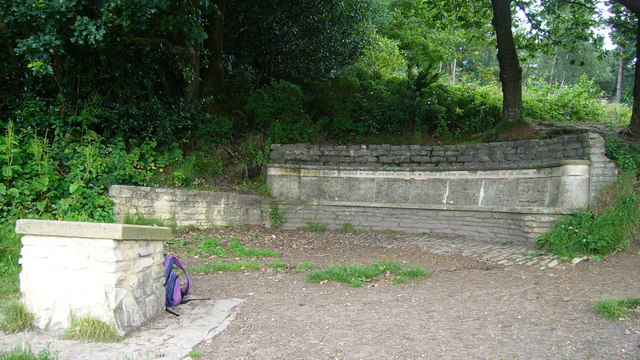
The National Trust owned area includes miles of woodland trails and wonderful viewpoints. It's located just a few miles north of Lurgashall and can be reached by following footpaths to Windfallwood Common and then up to the Temple of the Four Winds viewpoint. The route uses part of the Sussex Border Path which can be used to further explore the area. Following it west would take you to Marley Common just south of Haslemere.
Postcode
GU28 9ET - Please note: Postcode may be approximate for some rural locationsLurgashall Ordnance Survey Map  - view and print off detailed OS map
Lurgashall Open Street Map  - view and print off detailed map
Lurgashall OS Map  - Mobile GPS OS Map with Location tracking
Lurgashall Open Street Map  - Mobile GPS Map with Location tracking
Walks near Lurgashall
- Black Down - Climb to the highest point in the South Downs on this challenging route in Sussex
- Marley Common - This large green space in Haslemere is great for a peaceful stroll in lovely surroundings
- Serpent Trail - This walk runs from Haslemere to Petersfield through the beautiful Sussex greensand hills
- Ludshott Common - Explore this large area of heathland and woodland on this circular walk in East Hampshire
- Waggoners Wells - This short circular walk visits the Waggoners Wells beauty spot in East Hampshire
- Winkworth Arboretum - Enjoy a series of woodland walking trails in this beautiful arboretum in Godalming
- Greensand Way - The Greensand Way runs from Haslemere in Surrey to Hamstreet in Kent following the ridge of greensand rock that crosses the two counties
- Hydon's Ball and Hydon Heath - This National Trust owned hill is one of the high points of Surrey and a great place to stretch your legs
- Ludshott Common - Explore this large area of heathland and woodland on this circular walk in East Hampshire
- Bramshott Common - Explore this large expanse of heathland on this walk near Liphook in Hampshire
- Haslemere Circular Walk - This fine circular walk takes you around the Surrey town of Haslemere
Pubs/Cafes
Back in the village head to the The Noah's Ark Inn for some post exercise relaxation and refreshment. The country pub has a fine interior with beams and an inglenook fire. Outside there's a nice garden area with a stretch tent and views of the cricket on the Green in the summer. You can find them on the Green at postcode GU28 9ET for your sat navs.
Photos
"Temple of the Winds" viewpoint on Black Down. This viewpoint is on the Serpent Trail. The inscription reads "This seat was erected in memory of Mabel Elizabeth Hunter, wife of Edward W Hunter who gave Blackdown to the National Trust in 1944." Black Down is the highest point in all Sussex.


