Manningtree Circular Walk
![]()
![]() The Essex town of Manningtree is nicely located on the estuary of the River Stour in the Tendring district of the county. There's some lovely riverside paths and country walking opportunities along the long distance Essex Way which passes through the town.
The Essex town of Manningtree is nicely located on the estuary of the River Stour in the Tendring district of the county. There's some lovely riverside paths and country walking opportunities along the long distance Essex Way which passes through the town.
This circular walk in the town takes you along the River Stour before heading inland through the countryside and woodland to the south of the town. The route runs for just over 3 miles, using a mixture public footpaths and waymarked trails.
The walk starts from Mistley train station where you can pick up the Essex Way and follow it west along the river.
There's lovely views across the water to Seafield Bay and Cattawade on the other side. It's a very pleasant path with lots of yachts to see and a number of benches where you can stop to rest. You'll also pass the noteworthy Mistley Towers. These twin towers stood at each end of a now demolished Georgian church, and were designed by Robert Adam in 1776.
The route then leaves the river, turning south through the town. Head east and you will pass Dairy Wood, Laundry Wood and Furze Hill. At Mistley Heath you turn north west to return to the train station.
Postcode
CO11 1HB - Please note: Postcode may be approximate for some rural locationsManningtree Ordnance Survey Map  - view and print off detailed OS map
Manningtree Open Street Map  - view and print off detailed map
Manningtree OS Map  - Mobile GPS OS Map with Location tracking
Manningtree Open Street Map  - Mobile GPS Map with Location tracking
Walks near Manningtree
- Alton Water - Follow a mixture of well surfaced and unsurfaced cycling and walking trails around this large reservoir in Stutton, Ipswich
- Suffolk Coast Path - A walk along the beautiful Suffolk coast from Felixstowe to Lowestoft
- Dedham to Flatford Walk - This circular walk takes you from the village of Dedham to the site of Constable's most famous painting at Flatford Mill
- Dedham Vale - Explore John Constable country and visit the site of his famous Hay Wain painting on this circular walk in the Dedham Vale AONB
- Ardleigh Reservoir - This pretty reservoir near Colchester has a nice country lane running along its northern side
- Stour Valley Path - Follow the River Stour from Newmarket to Cattawade on this delightful walk through East Anglia
- St Edmund Way - A walk through Essex, Suffolk and Norfolk from Manningtree to Brandon
- Wrabness - This walk visits Bradfield and the lovely Wrabness Nature Reserve in Essex
- East Bergholt - This attractive Suffolk village is in a fine location for exploring the wonderful Dedham Vale AONB in Constable Country
- High Woods Country Park - This country park in Colchester includes woodland, open spaces, ponds, a lake and wildflower meadows
- Mistley - This Essex based village lies in a lovely spot on the River Stour just to the east of Manningtree.
Pubs/Cafes
The Mistley Place Park Tearooms are a nice place to go for some refreshments in the town. They do a good range of meals and snacks in a pleasant setting. You can find them on New Road at a postcode of CO11 1ER.
The Red Lion pub is another good option. It's an award winning pub and also the oldest one in the town. You can find it at 42 South Street with a postcode of CO11 1BG for your sat navs.
Dog Walking
The estuary is a fine place to take your dog for a walk. The Red Lion pub mentioned above is also dog friendly
Further Information and Other Local Ideas
On the opposite side of the river you can head into Suffolk and pick up the Suffolk Coast Path and view the town from a different perspective. Near here you can also visit the excellent Alton Water where there are some lovely waterside footpaths to try.
The town is also not far from the stunning Dedham Vale AONB where there are great walking opportunites. You can pick up the Stour Valley Path and follow the waymarked trail west to explore the area.
You could also head east along the Essex Way and visit the Wrabness Nature Reserve. There's beaches, woodland reserves and lots of wildlife to see here. You could also pick up the St Edmund Way which starts from the town.
For more walking ideas in the area see the Essex Walks page.
Photos
Mistley Towers, located by the river. These porticoed Classical towers are all that survive from the church of St Mary the Virgin, originally built in 1735 and re-modelled in an unconventional style by Robert Adam in 1776. The nave between the two towers was demolished in 1870 when a new church was built nearby. The Towers come under the overall supervision of English Heritage, but are managed by the local Residents' Association, from whom a key is available.
Manningtree Quay. The quay at Manningtree has not been used for over 100 years. It was closed at the end of the 19th century due mainly to siltation problems. The quay wall still remains, though raised to protect the area behind, which is owned by builders' merchants Jewsons.
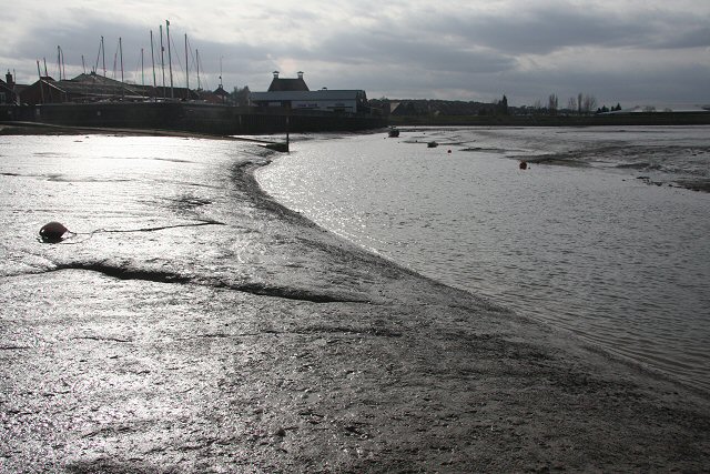
Mud flats. Looking westwards from the end of the hard. At low water the river splits into two, with this section passing close to the former Manningtree Quay, where yachts are now stored ashore


