Redwick Circular Walk
![]()
![]() This little Welsh village is located just south east of the city of Newport. There's some nice coastal trails along the Severn Estuary and Bristol Channel to enjoy here. The village also includes a notable medieval church which is Grade I listed.
This little Welsh village is located just south east of the city of Newport. There's some nice coastal trails along the Severn Estuary and Bristol Channel to enjoy here. The village also includes a notable medieval church which is Grade I listed.
This circular walk starts in the village and follows a section of the Wales coast path west along the sea wall and Portland Grounds to Goldcliff. Here you'll find the remains of a Benedictine Priory and pretty lagoons arond Golfcliff Pill. The coastal area is great for wildlife with lots of waders to look out for on the water.
The walk then heads east, following a mixture of country lanes and footpaths back to Redwick, passing Whitson on the way.
Postcode
NP26 3DU - Please note: Postcode may be approximate for some rural locationsRedwick Ordnance Survey Map  - view and print off detailed OS map
Redwick Open Street Map  - view and print off detailed map
Redwick OS Map  - Mobile GPS OS Map with Location tracking
Redwick Open Street Map  - Mobile GPS Map with Location tracking
Pubs/Cafes
Back in the village you can enjoy refreshments at The Rose Inn. The award winning pub stands in its own extensive grounds and forms the third corner of a triangle which defines the centre of Redwick village. There's a nice cosy interior and a good sized garden area for warmer days. You can find them at postcode NP26 3DU for your sat navs.
Further Information and Other Local Ideas
For a longer walk along the sea wall see the Newport Seawall Walk. This will take you along the wall from Goldcliff to Caldicot via Magor Pill. The start point is the Farmers Arms pub in Goldcliff which is well worth a visit.
If you continue west you could visit the Newport Wetlands. Here you'll find a large nature reserve with footpaths taking you around the Gwent Levels .
The Newport Canal Walk can also be picked up near the city.
Head east along the coast and you could visit the historic Caldicot Castle.
Cycle Routes and Walking Routes Nearby
Photos
Redwick, St Thomas's Church. The church porch has a marker depicting the level of flood water in the "Great Flood" of 1606. This is now thought to have been a tsunami. The church contains a fine Victorian pipe organ and two of the oldest church bells working in the country (cast in Bristol c.1350-80).
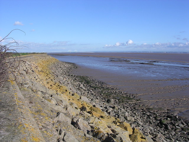
The sea wall approaching Redwick. Much of the sea wall along this section is like this. Mud flats stop where rocks have been built up to break up the incoming tide. They are capped with a concrete cap, about half a metre high. The wall itself is about three metres wide with the land to the left at a similar height to the mudflats.
Sea wall and mud flats. The sea wall just brushes this square. Just half an hour after low tide the extensive mud flats, which comprise most of the square, can be seen. In the distance, across the Severn Estuary, is the area around Portishead.
Gold Cliff. A quiet part of the coast near Newport showing [left] the now rather feeble remains of the wooden "rank" used to hold the distinctive conical putcher baskets which were set out against the ebb tide to catch salmon. A second rank once stood to the south west of the cliff. It is thought that this method of salmon fishing originated with the Romans and was continued by the monks at the 12th century Priory, sited on the cliff top until at least 1424. After the Dissolution the valuable fishing rights passed to Eton College as did most of the parish lands. The fisheries have now been closed for some years. (historical detail)


