Snowdon Miners Track
![]()
![]() This route follows the Miners Track to the summit of the highest mountain in Wales. It is a slightly longer route than the alternative Pyg Track but has the advantage of waterside sections alongside the mountain's three beautiful lakes of Llyn Teyrn, Llyn Llydaw and Glaslyn.
This route follows the Miners Track to the summit of the highest mountain in Wales. It is a slightly longer route than the alternative Pyg Track but has the advantage of waterside sections alongside the mountain's three beautiful lakes of Llyn Teyrn, Llyn Llydaw and Glaslyn.
The walk begins in the Pen y Pass car park and ascends to the pretty Llyn Teyrn before coming to the much larger Llyn Llydaw. The path crosses the lake and then runs right along it's northern edge, making for a lovely waterside section. At the lake you'll also pass the ruins of the old Britannia Copper Mine crushing mill.
You continue along a steep section to Llyn Glaslyn and then Bwlch Glas where you can see the tracks of the Snowdon Mountain Railway. The final section takes you from Bwlch Glas to the Snowdon summit where there are magnificent views over Snowdonia, Ireland, the Isle of Man, the Peak District and the Lake District.
The Pyg Track starts from the same car park. It is a shorter route but has more challenging rocky sections.
For an exhilarating circular ridge walk, taking in the Crib Goch ridge, try the Snowdon Horseshoe.
Postcode
LL55 4NU - Please note: Postcode may be approximate for some rural locationsSnowdon Miners Track Ordnance Survey Map  - view and print off detailed OS map
Snowdon Miners Track Open Street Map  - view and print off detailed map
Snowdon Miners Track OS Map  - Mobile GPS OS Map with Location tracking
Snowdon Miners Track Open Street Map  - Mobile GPS Map with Location tracking
Explore the Area with Google Street View 
Cycle Routes and Walking Routes Nearby
Photos

Miners Track to Snowdon

Glaslyn

The large stone marks the point where the Miners' Track leaves the shores of Glaslyn to rise steeply to meet the Pyg Track.

Mine Building on the Miner's Track. This is the largest of several derelict buildings on the Miner's Track up Snowdon.

Crib Goch and Llyn Llydaw from the Miner's Track. The final approach to Llyn Llydaw along the Miner's Track. Crib Goch is straight ahead but on this evening was soon blotted out as the storm seen approaching over Snowdon reached the lake within a few minutes.

Llyn Teyrn and the Snowdon Horseshoe. The Miners' Track curves round the north and eastern side of the lake. The pipeline in the distance carries water from Llyn Llydaw to the Cwm Dyli HEP station. The low lying area around the lake is very boggy.

An SAR Sea King HAR3 of 202 Sqdn RAF Valley follows the line of the Miners' Track. This photo, which also shows the splendour of the Snowdon Horseshoe, was taken along the section of track leading from Pen-y-pass to Llyn Teyrn.
_-_geograph.org.uk_-_1383.jpg)
Llyn Glaslyn and Llyn Llydaw (in distance) Looking into SH6154 from Bwlch Glas, below Snowdon summit. Pyg track is the higher level path. Miner's Track skirts the lakes. Paths rejoin at Pen y Pass, in SH6455
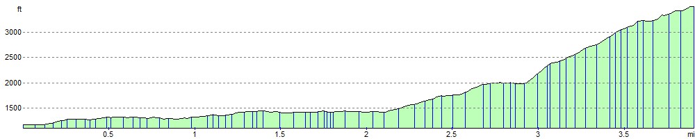
Elevation Profile