Warden's Way
![]()
![]() Follow the Warden's Way through the beautiful Cotswolds on this delightful 14 mile walk.
Follow the Warden's Way through the beautiful Cotswolds on this delightful 14 mile walk.
The walk starts in the picture postcard village of Bourton on the Water and passes through a series of picturesque villages including Lower and Upper Slaughter, Naunton and Guiting Power before finishing at Winchcombe.
Highlights on the walk include a lovely wooded section through Guiting Wood near Guiting Power and the 15th century Sudeley Castle with its beautiful, award winning gardens and lovely chapel. This is located near the end of the route at Winchcombe.
Though not particularly strenuous there are a few small climbs on the way.
Warden's Way Ordnance Survey Map  - view and print off detailed OS map
Warden's Way Open Street Map  - view and print off detailed map
Warden's Way OS Map  - Mobile GPS OS Map with Location tracking
Warden's Way Open Street Map  - Mobile GPS Map with Location tracking
Pubs/Cafes
In Bourton there's the noteworthy Mousetrap Inn for refreshment. The pub serves fine food and also has its own art gallery with landscape paintings in oil by local artist Silvi Schaumloeffel. There's a cosy, attractive interior with a log fire while outside there's a garden area for warmer days. You can find the inn at Lansdowne with a postcode of GL54 2AR for your sat navs.
In Lower Slaughter you could stop off at The Slaughters Country Inn. The inn serves fine food and has a lovely outdoor area next to the picturesque river. It's a great place to relax on a summer day. You can find them in Lower Slaughter at postcode GL54 2HS for your sat navs.
Further Information and Other Local Ideas
At the start of the route in Bourton the route links up with the Windrush Way. This popular waymarked trail explores the beautiful valley of the River Windrush. You could also pick up the popular Circular Walk from Bourton through Naunton and The Slaughters.
For more walking ideas in the area see the Cotswolds Walks page.
Cycle Routes and Walking Routes Nearby
Photos

Near Deadmanbury Gate. Having climbed up the Cotswold escarpment from Winchcombe the way descends gradually into Guiting Wood.

View from Wardens' Way. The track, part of the long distance path, leaves the Salt Way and starts to descend towards Sudeley. This view is looking south west. The prominent track, seen immediately above the fence post, is on Cole's Hill and neatly divides Spoonley Wood on the right, from Limehill Wood on the left.

The Wardens Way and Diamond Way. Two long distance footpaths follow this path out of Guiting Power. In the wooded valley to the right is a tributary of the River Windrush.

Here the Wardens' Way crosses a field of wheat or barley as it approaches a large barn near Upper Slaughter.

Upper Slaughter

Bourton on the Water

Gatehouse, Sudeley Castle

Hollow Bottom, Guiting Power
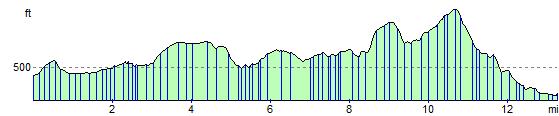
Elevation Profile