Yorkshire Wolds Walks

This area of Yorkshire includes some beautiful rolling hills with a number of pretty villages and interesting historic sites. The Wolds Way National Trail passes through the region and is a great way to see the area.
Use the links to view full route information including elevation profiles, interactive maps and GPS downloads.
You can also view an overview map of all the routes in the using the Yorkshire Wolds Walk Map>>
*New* - Walks and Cycle Routes Near Me Map - Waymarked Routes and Mountain Bike Trails>>
| Route Name | Photo | Distance | Description |
| Beverley Beck | 1.9 miles (3 km) | Enjoy a short stroll along the Beverley Beck on this easy walk in the Yorkshire town. There's a nice footpath running along the pretty beck which you can pick up just to the east of the Minster and train station. The path runs for just under a mile until it joins with the River Hull. Here you can extend the walk by following riverside paths south toward Woodmansey or north to Tickton. See our River Hull Walk for more details on this. On the way you'll enjoy the tranquil waters of the beck, flanked by attractive woodland and new housing. At the eastern end you'll come to the lock gates near its junction with the River Hull. The lock gates and pumping station were restored in early 2007 and make for a nice photo. At the end of the beck the route heads back towards the town centre on the same paths. View Full Details>> | |
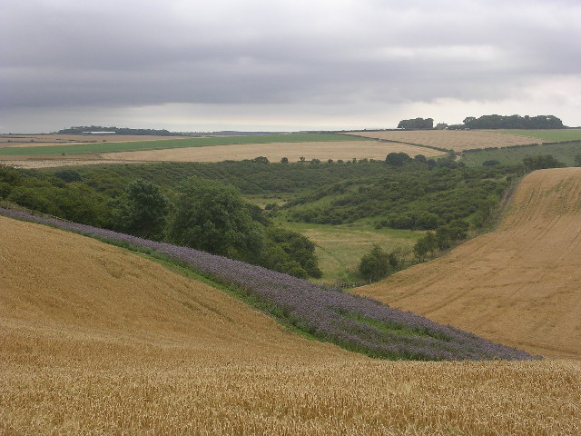
| Beverley Twenty | 19.9 miles (32 km) | This 20 mile walk runs from Hessle to Beverley through the Yorkshire wolds. The walk starts near Hull in Hessle, at Humber Bridge Country Park and takes you to the Humber Estuary with fine views of the Humber Bridge. The path then follows the estuary to North Ferriby where you turn north and head towards Beverley through the countryside of the Yorkshire Wolds. The walk passes Welton Dale and the pretty village of Skidby, with its English Heritage windmill, before finishing at the splendid Beverley Minster. View Full Details>> | |
| Bishop Wilton | 9.6 miles (15.5 km) | This pretty little village in the East Riding of Yorkshire is a pleasant place to start a walk into the Yorkshire Wolds. The village includes a Grade I listed medieval church and is close to the highest point in the Wolds at Garrowby Hill. View Full Details>> | |
| Brantingham | 6.8 miles (11 km) | The Yorkshire Wolds village of Brantingham has a number of waymarked trails running through the area. This circular walk makes use of the Yorkshire Wolds Way, the High Hunsley Circuit and the Beverley Twenty to take you on a tour of the countryside to the east of the village. You'll visit some of the local wolds and dales with some peaceful woodland sections and a visit to the village of Welton. It's a lovely rural setting with some beautiful scenery to admire. The walk starts in Brantingham which is very pretty village with an attractive green and duck pond in the centre. From here you head east along the Beverley 20 to Turtle Hill. You then turn south, passing attractive Wauldby where there's a manor farm, a church, a pond and some pockets of woodland. The route then heads along the Wolds Way through the woodland of Welton Dale to the village of Welton. It's a picturesque village with a mill pond and village green with a memorial fountain. There's also an 18th century mill and a the Green Dragon Pub which is a nice place to stop for refreshments. After exploring the village you head north west through Elloughton Wold and Elloughton Dale before a short woodland section takes you back into Brantingham. View Full Details>> | |
| Centenary Way Yorkshire | 83.3 miles (134 km) | Explore the Howardian Hills and the Yorkshire Wolds on this splendid walk devised to celebrate the 100th anniversary of Yorkshire County Council. The walk starts at the fabulous York Minster next to the Roman York Walls in the historic city. View Full Details>> | |
| Chalkland Way | 39.8 miles (64 km) | This circular walk takes you on a tour of the beautiful Yorkshire Wolds around Pocklington, where the walk starts and ends. You will pass through Britain's most northerly chalk outcrop while also visiting a series of pretty villages including Great Givendale, Thixendale, Fimber, Wetwang and Huggate. You'll also pass near Millington Woods which make a nice detour from the route if you have time. View Full Details>> | |
| Driffield | 6.8 miles (11 km) | This circular walk explores the Driffield Canal before heading to the neighbouring village of Nafferton along the Nafferton Brook. The route runs for just under 7 miles on a series of flat footpaths so is suitable for most abilities. View Full Details>> | |
| Goodmanham | 6.8 miles (11 km) | A circular walk from the Wolds settlement of Goodmanham exploring the countryside to the east of the village. The route uses sections of the waymarked Yorkshire Wolds Way and Hudson Way which run through the area. You'll visit attractive wolds and dales with a visit to a chalk pit nature reserve as well. The walk starts in the village where you can pick up the Yorkshire Wolds Way. View Full Details>> | |
| High Hunsley Circuit | 24.2 miles (39 km) | Travel through the beautiful Yorkshire Wolds on this delightful circular walk. The walk starts and ends in Brantingham Thorpe park and visits the villages of Walkington, Skidby, Brantingham, South Cave and Bishop Burton. The scenery is varied with sections through parkland, woodland and open countryside to enjoy. View Full Details>> | |
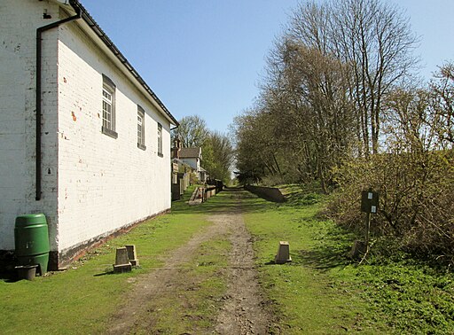
| Hudson Way | 9.9 miles (16 km) | This shared cycling and walking route runs along a disused railway path from Beverley to Market Weighton in East Riding of Yorkshire. View Full Details>> | |
| Huggate | 8.1 miles (13 km) | This circular walk from the East Riding village of Huggate visits the neighbouring village of Fridaythorpe using a section of the Yorkshire Wolds Way and other public footpaths. View Full Details>> | |
| Hunmanby Circular Walk | 10 miles (16.1 km) | This route around Hunmanby makes use of the Wolds Way and Centenary Way to create a fine circular walk. You'll enjoy some splendid coastal scenery around Filey and lovely Yorkshire Wolds countryside for the duration of the walk. The route runs for about 10 miles on reasonably flat paths, with some moderate climbs around Folkton Wold. The walk starts from the large village of Hunmanby, in the Scarborough district of North Yorkshire. The route begins by following the Centenary Way north east, through the countryside, to Filey. You then head north along Filey Bay with the option of continuing to the popular Filey Brigg Country Park. Here you will find a long narrow peninsula with steep cliffs and lovely coastal views. After exploring the coast you then pick up the Wolds Way National Trail to take you west through the town and back into the countryside. The trail leads south west through the village of Muston, before climbing towards Deedle Hill and Folkton Wold. There's some splendid views over the beautiful Wolds countryside from the high points. You then descend through Stocking Dale where you turn left to pick up the Centenary Way again. This will lead you back into Hunmanby where the walk finishes. View Full Details>> | |
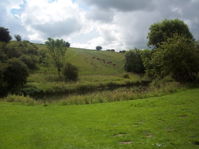
| Millington Woods | 0.9 miles (1.5 km) | Visit these delightful woods in the Yorkshire Wolds on this short walk near Pocklington. The site consists of the best ancient ash woods in the Yorkshire Wolds. You can also enjoy carpets of bluebells, giant bellflowers and the scent of wild garlic. There's a nice surfaced walking trail running from the car park to a view point where you can admire a fine panoramic view across the treetops. The Minster Way and the Yorkshire Wolds Way both run past the woods so you could pick up these long distance footpaths to extend your walk. You could then explore the lovely Sylvan Dale and Millington Dale which are right next to the woods. You could actually reach the woods by following the Wolds Way from Pocklington. National Cycle Route 164 also runs to the woods from Pocklington so it's easy to cycle there too. There's also a car park just off Wood Gate Road at the southern end of the site. View Full Details>> | |
| Minster Way | 49.7 miles (80 km) | This splendid walk runs between the well known minsters at Beverley and York, visiting Arram, Scorborough, North Dalton, Lockington, Millington, Great Givendale, Bishop Wilton, Full Sutton, Stamford Bridge, Kexby and Fulford. The path crosses the chalk hills of the Yorkshire Wolds, as well as a wide variety of beautiful East Yorkshire countryside. Highlights include delightful waterside stretches along the River Derwent and along the River Ouse into York. You'll also pass the pretty Millington Woods at Millington. View Full Details>> | |
| Risby Round | 2.9 miles (4.6 km) | This circular walk explores the deserted village of Risby in East Riding of Yorkshire. Risby Park includes lakes, woodland and some lovely views of the surrounding countryside. View Full Details>> | |
| River Hull | 5 miles (8 km) | Enjoy a walk along the Beverley Beck and the River Hull on this pleasant waterside walk in Beverley. The route runs for just under 5 miles on a series of very flat, public footpaths. The walk starts at the Beverley Beck, just a short distance east of the Minster and train station. Follow the pleasant footpath east until it meets with the River Hull at the recently restored lock gates and pumping house. You then turn north toward Tickton where you can cross the river and follow the path on the eastern side for a while. The route then crosses back to the western side and follows the beck back into Beverley. View Full Details>> | |
| Rudston | 4 miles (6.5 km) | A circular walk around the East Riding of Yorkshire village of Rudston visiting the Rudston Monolith and the countryside to the south east of the village. View Full Details>> | |
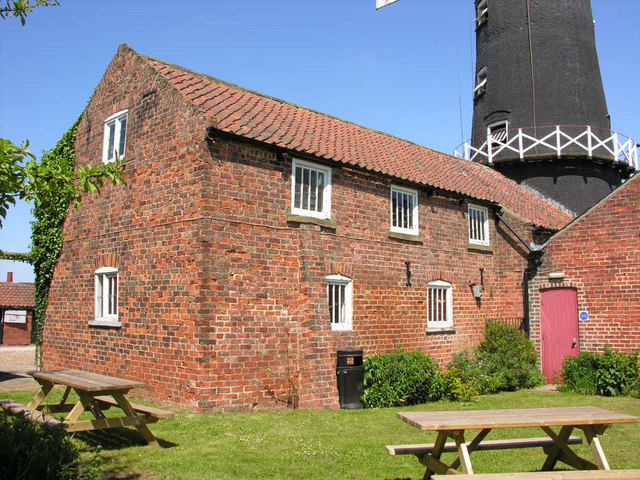
| Skidby Mill | 1.9 miles (3 km) | This circular walk visits Skidby Windmill near Beverley, in the East Riding of Yorkshire. The Grade II listed mill dates back to 1821 and is a popular local attraction. Inside there's an interesting museum where you can learn all about the history of the area. View Full Details>> | |
| Sledmere House | 3.1 miles (5 km) | Explore the beautiful Capability Brown designed park surrounding this fine Georgian country house near Driffield. Well laid out footpaths take you through woodland, parkland and gardens. In the walled garden you can see 30,000 tulips while in the grounds there's red deer, yew topiary and a ha ha. There is also a knot garden and a paved sculpture court. It's a fabulous place for a peaceful stroll with 960 acres of parkland to explore. You can also tour the house with its fine rooms, paintings and furniture. View Full Details>> | |
| South Cave | 11.8 miles (19 km) | The village of South Cave is located in the East Riding of Yorkshire and the Yorkshire Wolds. This circular walk from the village visits some of the lovely wolds and dales in the surrounding area. You'll visit Brantingham Wold, Welton Dale, Cave Wold and Great Wold with some lovely rolling countryside to enjoy on the way. The route runs for just over 12 miles using sections of the Yorkshire Wolds Way, the Beverley Twenty and other public footpaths. View Full Details>> | |
| Thixendale | 7.9 miles (12.7 km) | This circular walk explores the lovely Yorkshire Wolds countryside surrounding the little village of Thixendale in Ryedale. You'll enjoy some beautiful rolling countryside and also pay a visit to the fascinating medieval village of Wharram Percy. The 8 mile walk makes use of the Yorkshire Wolds Way and the Centenary Way, two waymarked trails which run through the area. It includes a few moderate climbs so a reasonable level of fitness is required. Start the walk from Thixendale and follow the Wolds Way, north east through Cow Wold. You then turn east and head towards the beautiful Deep Dale and Wharram Percy Wold. Here you will find the deserted village which includes a ruined church and a mill pond with the layout of the other buildings visible in the surrounding fields. The route loops around the site before picking up the Centenary Way toward the pretty Fairy Dale and the Fairy Stones. Here you turn west, passing Raisthorpe Wold before heading south through the delighful scenery of Court Dale and Water Dale to return to Thixendale. Here you can enjoy refreshments at the Cross Keys pub, which is a regular winner of the local CAMRA (Campaign for Real Ale) awards. View Full Details>> | |
| Walkington | 3.7 miles (6 km) | This village is located on the Beverley Twenty Walk just west of Beverley in East Riding of Yorkshire. View Full Details>> | |
| Welton Dale | 5 miles (8 km) | A circular walk around Welton Dale in East Riding of Yorkshire. The walk makes use of the Yorkshire Wolds Way and Beverley Twenty to create a circular walk around the village and its associated dale. View Full Details>> | |
| Wharram Percy | 5 miles (8 km) | This circular walk visits the fascinating medieval village of Wharram Percy in the Yorkshire Wolds. After strolling around the site you'll then pick up sections of the Yorkshire Wolds Way and the Centenary Way to explore the surrounding countryside. View Full Details>> | |
| Yorkshire Wolds Way | 78.9 miles (127 km) | Starting on the banks of the Humber Estuary at Hessle follow this charming route through the peaceful and beautiful Yorkshire countryside. The route runs for 79 miles passing through a series of charming villages as you wend your way through the delightful Yorkshire Dales to the finish point on the coast at Filey. Route highlights include: The picturesque landscape at Londesborough Park near Market Weighton. The lovely Filey Brigg Country Park on the coast at the end of the route is another splendid feature. Wharram Percy - the route passes through the remains of this fascinating medieval village which dates from the 10th century. View Full Details>> |