Sittingbourne to Canterbury
![]()
![]() Follow National Cycle Route 1 through Kent from Sittingbourne to Canterbury.
Follow National Cycle Route 1 through Kent from Sittingbourne to Canterbury.
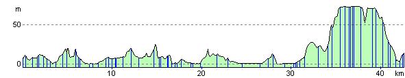
The route starts by heading east to Conyer, Faversham and then onto Whitstable berfore turning south to Canterbury. Highlights include the partly off road Swale Heritage trail at the start followed by a lovely coastal stretch through Seasalter and Whitstable with splendid views of Whitstable Bay. The final approach to Canterbury is also pleasant, passing through Clowes Wood on off road tracks before finishing in Canterbury at the train station.
Sittingbourne to Canterbury Ordnance Survey Map  - view and print off detailed OS map
Sittingbourne to Canterbury Open Street Map  - view and print off detailed map
Sittingbourne to Canterbury OS Map  - Mobile GPS OS Map with Location tracking
Sittingbourne to Canterbury Open Street Map  - Mobile GPS Map with Location tracking
Further Information and Other Local Ideas
Just east of Canterbury you can visit the Stodmarsh National Nature Reserve which boasts the largest reedbeeds in the South East of England. This area also includes the lovely Grove Ferry Walk which starts at the eastern end of the reserve. There's a car park, picnic area, boat trips and a fine riverside pub here. At the western end of the reserve you'll also find the Westbere Marshes and the noteworthy town of Fordwich. Fordwich is notable as Britain's smallest town and also has a great pub with a dining terrace overlooking the Stour.
Cycle Routes and Walking Routes Nearby
Elevation Profile