Solihull Way Walk to Castle Bromwich Hall Birmingam
![]()
![]() Starting at Earlswood Lakes head through Solihull to Castle Bromwich Hall. The path first takes you over the Stratford Upon Avon Canal and then along the Grand Union Canal. You then pass through Elmdon Park and Sheldon Country Park and past Birmingham International Airport before finishing at the Jacobean Mansion at Castle Bromwich Hall.
Starting at Earlswood Lakes head through Solihull to Castle Bromwich Hall. The path first takes you over the Stratford Upon Avon Canal and then along the Grand Union Canal. You then pass through Elmdon Park and Sheldon Country Park and past Birmingham International Airport before finishing at the Jacobean Mansion at Castle Bromwich Hall.
Solihull Way Ordnance Survey Map  - view and print off detailed OS map
Solihull Way Open Street Map  - view and print off detailed map
*New* - Walks and Cycle Routes Near Me Map - Waymarked Routes and Mountain Bike Trails>>
Solihull Way OS Map  - Mobile GPS OS Map with Location tracking
Solihull Way Open Street Map  - Mobile GPS Map with Location tracking
Further Information and Other Local Ideas
The circular Solihull Walk uses part of the trail and visits several of the local highlights including Malvern and Brueton Park, the Grand Union Canal, the Stratford Upon Avon Canal, Knowle, the National Trust's Baddesley Clinton, Hay Wood and the lovely Earlswood Lakes.
The River Cole Valley Cycle Route meets with the trail at Bacon's End. The path can be followed all the way to Yardley Wood along the river. It's a 10 mile route along a nice flat path, passing through the Birmingham suburbs. On the way it also passes the noteworthy Sarehole Mill. The 16th century mill is notable as Birmingham's last surviving water mill and well worth a visit. Near the mill there's the Moseley Bog Nature Reserve to explore as well. Here you can enjoy more easy trails around the ancient woodland with lots of wildlife to see on the way.
For more walking ideas in the area see the West Midlands Walks page.
Cycle Routes and Walking Routes Nearby
Photos

Earlswood Lakes

Castle Bromwich Hall

Grand Union Canal near Elmdon Heath, Solihull

West along the Grand Union
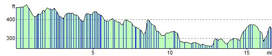
Elevation Profile