Standedge Trail
![]()
![]() A lovely circular walk through Kirklees visiting the Standedge Tunnels. The path starts off at Marsden, near the railway station, and heads towards Diggle before turning round and returning to Marsden. The route crosses the wonderful Marsden Moor Estate with its heather moorland and far reaching views over the Pennines and the Peak District. You'll pass near Black Moss and Redbrook Reservoir and enjoy a canal side stretch towards the end of the route. You'll also pass the noteworthy Standedge Tunnels. The canal tunnel was opened in 1811 and is the longest and highest canal tunnel in the United Kingdom.
A lovely circular walk through Kirklees visiting the Standedge Tunnels. The path starts off at Marsden, near the railway station, and heads towards Diggle before turning round and returning to Marsden. The route crosses the wonderful Marsden Moor Estate with its heather moorland and far reaching views over the Pennines and the Peak District. You'll pass near Black Moss and Redbrook Reservoir and enjoy a canal side stretch towards the end of the route. You'll also pass the noteworthy Standedge Tunnels. The canal tunnel was opened in 1811 and is the longest and highest canal tunnel in the United Kingdom.
Your walking in the area can be extend along the Huddersfield Narrow Canal or by picking up the long distance Oldham Way which passes through the area.
Standedge Trail Ordnance Survey Map  - view and print off detailed OS map
Standedge Trail Open Street Map  - view and print off detailed map
Standedge Trail OS Map  - Mobile GPS OS Map with Location tracking
Standedge Trail Open Street Map  - Mobile GPS Map with Location tracking
Pubs/Cafes
In Marsden there's the noteworthy Riverhead Brewery Tap to stop at on the route. It does good food and is an excellent place for real ale connsiseurs. On the ground floor in the bar, there are 10 real ale hand pumps several of which are permanently dedicated to the popular Riverhead beers brewed on-site. The famous Riverhead micro-brewery is housed downstairs in the cellar. Here they brew a wide range of beers all with a local connection. Hot and cold food is served regularly with all dishes freshly prepared on site. You can find the pub in the picturesque village, next to the River Colne, on Peel Street with a postcode of HD7 6BR for your sat navs.
The Diggle Lock is another good option. It's located in a re-purposed textile mill near to the canal. They have a fine menu and can be found at Warth Mill, OL3 5PJ.
Further Information and Other Local Ideas
The Pule Hill Walk starts from Marsden train station and uses a section of the trail to create a circular walk around the canal, the moors and the hill.
For more walking ideas in the area see the South Pennines Walks page.
Cycle Routes and Walking Routes Nearby
Photos

Standedge Tunnel. Tunnel End, at the Yorkshire end of the tunnel. Standedge tunnel is the Longest, Highest (above sea level) and deepest (below the hills above) canal tunnel in the UK.

Western portal of Standedge Tunnel at Diggle. View NE from the A62 road, towards Huddersfield, Leeds etc.: ex-LNWR Manchester - Huddersfield - Leeds main line. Behind the camera is the site of the former Diggle station. There are four tunnels here: the two tracks remaining constitute the main line, through the most recent (1894) tunnel bore, next to the right the original (1811) canal tunnel runs underneath here. Further over to the right are the original (1848 and 1871) single-line rail tunnels, still extant but with no track although one is available for emergency road vehicles.

Standedge Trail. The stone bridge spans the feeder stream from Redbrook Reservoir for the Huddersfield Narrow Canal

The trail at Thieves Clough Bridge. View towards Pule Hill from the former road over Standedge

View towards Diggle Edge

Standedge Tunnel and canal view at Diggle. Workmen can be seen entering the tunnel in June 2001.

Redbrook Reservoir. Small feeder reservoir for the Huddersfield Narrow Canal.
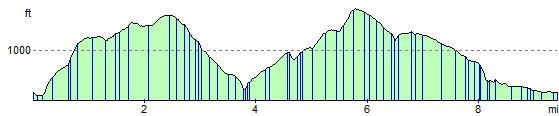
Elevation Profile