Thanet Coastal Path
![]()
![]() Travel from Reculver to Pegwell Bay and enjoy bays, beaches and spectacular cliffs along this beautiful coastal path. The walk passes through several delightful coastal towns and villages including Birchington, Westgate on Sea, Margate and Ramsgate before finishing at the lovely Pegwell Bay.
Travel from Reculver to Pegwell Bay and enjoy bays, beaches and spectacular cliffs along this beautiful coastal path. The walk passes through several delightful coastal towns and villages including Birchington, Westgate on Sea, Margate and Ramsgate before finishing at the lovely Pegwell Bay.
Route highlights include the variety of coastal wildlife, the popular Botany Bay and the attractive harbours at Margate and Ramsgate. You'll also pass the delightful town of Broadstairs with its strong connections to Charles Dickens and wonderful views over Viking Bay.
Thanet Coastal Path Ordnance Survey Map  - view and print off detailed OS map
Thanet Coastal Path Open Street Map  - view and print off detailed map
Thanet Coastal Path OS Map  - Mobile GPS OS Map with Location tracking
Thanet Coastal Path Open Street Map  - Mobile GPS Map with Location tracking
Further Information and Other Local Ideas
The Turner Contemporary art gallery in Margate is a nice place to visit on the route. It's free to enter and located right on the sea front. Founded to celebrate JMW Turner’s connection to Margate in 2001, the David Chipperfield designed gallery opened in 2011. There's a rolling programme of temporary exhibitions and wide windows showcasing the views that inspired painter J. M. W. Turner. The artist went to school in Margate, and visited the town throughout his life. The gallery also houses a nice cafe which is a good spot for refreshments after your exercise.
Cycle Routes and Walking Routes Nearby
Photos

Lagoon by The Thanet Coastal Path. West of Minnis Bay, near the Wantsum River.

View from the churchyard, Reculver, of the Thanet Coastal Path towards Herne Bay

This cannon is one of two which can be seen on the path near Margate. It is located off the B2051 Fort Hill as it slopes upward from the Lifeboat Station towards Cliftonville. I am unsure of which period they date from, but they remain in all their glory here today! View taken looking north-northwest - out to sea.

Cyclists on the trail near Birchington

Towards St Mary's church

Newgate Gap Bridge

View of Westgate from Grenham Bay. West of Birchington and around a blind bend on the Thanet Coastal Path near Grenham Bay brings this excellent view of Westgate-on-Sea (just a mile or two to the east). The beach huts along the promenade are clearly visible, as are a number of houses, apartments and hotels. The photographer's location is just inside the bottom edge of the gridsquare looking east.

Barrier Beach and Lagoon, Plumpudding Island
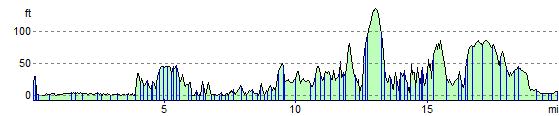
Elevation Profile