Tunbridge Wells Circular Walk
![]()
![]() Explore the beautiful countryside around Royal Tunbridge Wells on this circular walk through the High Weald AONB. The walk passes through a series of steep ridges and valleys used by climbers including Eridge Rocks and Harrison's Rocks. Other highlights include the woodland through Eridge park and Groombridge Place with its moated manor house and beautiful gardens. You'll also pass Tunbridge Wells Common, Pembury Woods and the delightful Dunorlan Park as you pass through the town.
Explore the beautiful countryside around Royal Tunbridge Wells on this circular walk through the High Weald AONB. The walk passes through a series of steep ridges and valleys used by climbers including Eridge Rocks and Harrison's Rocks. Other highlights include the woodland through Eridge park and Groombridge Place with its moated manor house and beautiful gardens. You'll also pass Tunbridge Wells Common, Pembury Woods and the delightful Dunorlan Park as you pass through the town.
The route skirts the southern edge of Tonbridge where you could take a small detour to visit the historic castle and enjoy walks along the River Medway on the Medway Valley Walk. Near here the route also passes close to Tudeley Woods, an RSPB Nature Reserve with a large variety of flora and fauna to see.
The start and finish point for the route is at Southborough Common.
Tunbridge Wells Circular Walk Ordnance Survey Map  - view and print off detailed OS map
Tunbridge Wells Circular Walk Open Street Map  - view and print off detailed map
*New* - Walks and Cycle Routes Near Me Map - Waymarked Routes and Mountain Bike Trails>>
Tunbridge Wells Circular Walk OS Map  - Mobile GPS OS Map with Location tracking
Tunbridge Wells Circular Walk Open Street Map  - Mobile GPS Map with Location tracking
Pubs/Cafes
The Barn pub in Tunbridge Wells is an establishment of some note. It has an interesting history having been reconstructed from a centuries old Elizabethan Barn which was originally built in a nearby Kent village and re-erected on its present site. Recreated in the original Kentish style with oak beams and columns throughout it has an interior full of character. Outside there is a delightful award winning courtyard garden. Heated for cooler days and beautifully illuminated at night, it's really very pretty and a lovely place to relax with refreshments after your exercise. You can find the pub in the town centre at 1 Lonsdale Gardens, Mount Pleasant Road with a postcode of TN1 1NU for your sat navs.
Near Eridge Rocks you can visit the Nevill Crest and Gun at Eridge Green. It's a pub of some note being housed in a building with over 500 years of history. The unusually named inn is named after the crest of the Nevill family, the Earls of Abergavenny, on whose estate the pub was built: it is their monogram that adorns the building and many others in the surrounding area. The 'Gun' part of the name arose from a forge on the estate which produced cannons and cannon balls for the Nevilles: at one time an ancient cannon, made of strips of metal held together with hoops, was fired on fair days or days of celebration, and it is this that is referred to in the name. Many of the local villagers would have been employed in the forge. The pub has a splendid interior with atmospheric, beamed rooms and roaring fires along with a lighter garden room. Outside there's a large garden area where you can relax on finer days.


Pictured above: The Nevill Crest and Gun pub. An ideal pit stop on the walk. It's also dog friendly if you have your canine friend with you.
In Groombridge you could stop off at the very fine on site cafe within Groombridge Place. If you prefer a pub then the Crown Inn is a good choice. It's located in a great spot just across the road from the manor house. The historic 16th century pub is notable as one of the oldest in the South of England. As you'd expect there's a charming olde worlde interior with a cosy beamed restaurant and log fires. They do high quality food and can be found at a postcode of TN3 9QH.
In Speldhurst you'll find The George and Dragon, a historic pub of some note. The pub is housed in a building dating back to 1212 which was originally a manor house of some importance. It is thought Kentish Archers were treated to a banquet in the Great Hall on their return from Agincourt in 1415. They serve high quality food which can be enjoyed in the charming interior or outside in the sunny garden. You can find them at postcode TN3 0NN for your sat navs.
Further Information and Other Local Ideas
Just west of the town look out for the High Rocks National Monument. It's a fantastic spot with a series of huge sandstone rocks and some lovely wooded areas to explore. There's also a picnic area and a great pub at this major route highlight.
Cycle Routes and Walking Routes Nearby
Photos

Leggs Lane. The long distance path heads right towards Bullingstone, or along the lane before heading towards Langton Green.

Waymarker on the route. In the background is Shadwell Wood.

Through Pippins Farm. This long distance path leads from Maidstone Road to Romford Road. Various fruit are grown in the many orchards beside this farm path.

Chase Wood

Groombridge House. A 17th Century brick mansion in its own parkland of avenues and garden terraces. Looking diagonally across the moat.

Ancient Oak in field beside Eridge Old Park. The trail here heads from Frant to Eridge Green. The track leads alongside Eridge Old Park, past some very old trees.
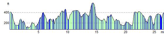
Elevation Profile