Braintree to Colchester
31.1 miles (50 km)
![]()
![]() This route starts near Braintree rail station and heads to Witham along National Cycle route 16 and country lanes. From there you join National Cycle route 1, which takes you to Colchester on a mixture of country roads and off road paths.
This route starts near Braintree rail station and heads to Witham along National Cycle route 16 and country lanes. From there you join National Cycle route 1, which takes you to Colchester on a mixture of country roads and off road paths.
Braintree to Colchester Ordnance Survey Map  - view and print off detailed OS map
Braintree to Colchester Open Street Map  - view and print off detailed map
Braintree to Colchester OS Map  - Mobile GPS OS Map with Location tracking
Braintree to Colchester Open Street Map  - Mobile GPS Map with Location tracking
Further Information and Other Local Ideas
On the northern side of Colchester there's High Woods Country Park to explore. There's some pleasant cycling and walking trails with a lake, woodland trails and a visitor centre to be found in this popular park. The picturesque Ardleigh Reservoir can also be found near here.
In Witham you can pick up the popular Blackwater Rail Trail. The shared cycling and walking route will take you along the River Blackwater to Maldon via Wickham Bishops.
Cycle Routes and Walking Routes Nearby
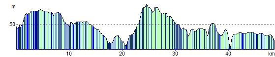
Elevation Profile