Brenda Parker Way OS Map
![]()
![]() This splendid walk runs from Aldershot to Andover through the Hampshire countryside. The walk passes through Fleet, Winchfield, Bramley, Tadley, Kingsclere, Ecchinswell, Highclere, Sidley Bottom, and Rag Copse. Highlights include:
This splendid walk runs from Aldershot to Andover through the Hampshire countryside. The walk passes through Fleet, Winchfield, Bramley, Tadley, Kingsclere, Ecchinswell, Highclere, Sidley Bottom, and Rag Copse. Highlights include:
- A waterside section along the Basingstoke Canal
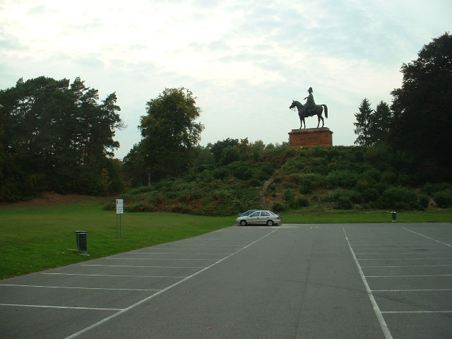
- The Wellington Statue - Near the Royal Garrison Church stands the 30 foot statue of the first Duke of Wellington, mounted on his horse, Copenhagen. It was commissioned to mark his victory at the 1815 Battle of Waterloo and is made mainly from bronze cannons captured at the time.
- Fleet Pond - Hampshire's largest lake is also a peaceful nature reserve and a great place for wildlife spotting.
- Calleva - an ancient Roman Town near the village of Silchester. See video below for more details
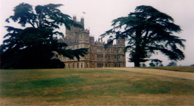
- Highclere Castle - home of the discoverer of the tomb of Tutankhamun and location for period drama 'Downton Abbey'. The route heads through part of the wonderful 5000 acre estate.
- Pilot Hill - Hampshire’s highest point.
The Brenda Parker Way is marked in both directions with waymark discs.
Brenda Parker Way Ordnance Survey Map  - view and print off detailed OS map
Brenda Parker Way Open Street Map  - view and print off detailed map
*New* - Walks and Cycle Routes Near Me Map - Waymarked Routes and Mountain Bike Trails>>
Brenda Parker Way OS Map  - Mobile GPS OS Map with Location tracking
Brenda Parker Way Open Street Map  - Mobile GPS Map with Location tracking
Pubs/Cafes
In Kingsclere you could stop off at the The Crown. The classic village pub includes a cosy interior with a log fire for the winter days. In warmer weather there's the outdoor area where you can sit and watch the world go by. They have a good menu and can be found at postcode RG20 5QU for your sat navs.
In Tadley there's The Pelican to consider. They serve traditional Pub Grub and Thai Food which you can enjoy in the large garden area. The historic inn dates back to 1860 and can be found at Silchester Road, Pamber Heath, RG26 3EA. The expansive Pamber Forest is located here too so you could enjoy some woodland trails and wildlife if you have time.
There's also the Fox & Hounds at Mulfords Hill in Tadley town at postcode RG26 3JG.
In Bramley there's the 19th century Bramley Inn. They serve good quality Indian food and have a nice garden area as well. You can find them at postcode RG26 5BT for your sat navs. The village is also worth exploring with a noteworthy 12th century church to see.
Further Information and Other Local Ideas
At Kingsclere you could take a small detour from the route to climb to Watership Down. The hill was made famous by Richard Adams' 1972 novel and the subsequent 1978 animated film. There are some splendid views from the elevated position of the Down.
At Sherfield on Loddon you could stop off at the splendid Longbridge Mill. The 15th century mill includes a working flour mill on the banks of the River Loddon with a visitor centre and a fine pub for refreshment.
For more walking ideas in the area see the Hampshire Walks page.
Cycle Routes and Walking Routes Nearby
Photos
Highclere Castle - Built in 1777. 18th century Landscape gardens with historic Lebanon cedar trees. You can also climb to the viewpoint on Beacon Hill in the estate.
Footpath, Pilot Hill. The footpath descends to a valley before climbing again on its way to Faccombe. The new wooden gate is to provide provide access to the down which is designated access land.
Basingstoke Canal, approaching Ash Lock, Aldershot. The lock-gates are behind the bridge carrying Government Road, which in turn is behind a large pipeline. The canal was opened in 1794 between Basingstoke and the River Wey Navigation. It soon fell victim to competition from the London to Southampton Railway, and became derelict. It was purchased by Hampshire and Surrey County Councils in the mid-1970s and was restored by a volunteer workforce. It was reopened in 1991 and the Basingstoke Canal Authority formed to manage it.
Elevation Profile


