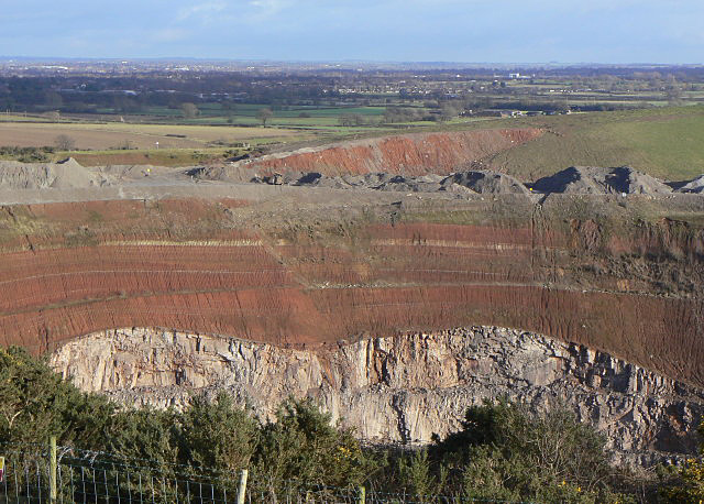
Croft Hill and Quarry Walk

 This walk visits the Croft Hill viewpoint and the old Croft Quarry near Leicester. It's a photogoenic spot with fascinating geology and fine views over the area from the hill top. There's no public access to the quarry itself but there are public footpaths heading around the site with fine views down to the quarry workings.
The walk starts in the village and follows footpaths north to the River Soar at Croft Bridge before heading along the western side of the quarry. This will take you up to Croft Hill which stands at a height of 128 metres at the northern end of the quarry. From here there are excellent views over the quarry to the surrounding countryside. You can then pass along a path heading north east towards the neighbouring village of Huncote.
Postcode
LE9 3GP - Please note: Postcode may be approximate for some rural locationsCroft Hill and Quarry Walk Ordnance Survey Map  - view and print off detailed OS map
Croft Hill and Quarry Walk Open Street Map  - view and print off detailed map
Croft Hill and Quarry Walk OS Map  - Mobile GPS OS Map with Location tracking
Croft Hill and Quarry Walk Open Street Map  - Mobile GPS Map with Location tracking
Pubs/Cafes
Back in the village the 18th century Heathcote Arms is a good choice for some post walk refreshment. They serve good quality home cooked food which you can enjoy in there lovely garden area. You can find them on Hill Street with a postcode of LE9 3EG for your sat navs.
Dog Walking
The walk is a nice one to do with your dog and the Heathcote Arms mentioned above is also dog friendly.
Further Information and Other Local Ideas
You could follow footpaths south west to visit the lakes at Stoney Stanton and more old quarries at Sapcote. The area includes Stoney Cove, a flooded quarry now home to the UK’s National Diving Centre where you can enjoy scuba diving and other activities.
In nearby Sharnford you could also pick up the Leicestershire Round and follow the waymarked circular trail through the county.
A few miles to the north west there's Market Bosworth Country Park where you can visit the historic Bosworth Battlefield. The picturesque Sutton Cheney Wharf on the Ashby Canal can also be explored in this area.
Head west towards Hinckley and there's some good cycling and walking trails to be found on Burbage Common.
For more walking ideas in the area see the Leicestershire Walks page.


