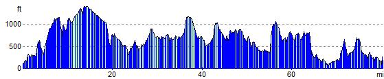
Dartmoor Way Walk and Cycle - Map and GPX
![]()
![]() This epic long distance circular walk takes you on a tour of the wonderful Dartmoor National Park.
On the circular route you will pass Okehampton, Chagford, Moretonhampstead, Buckfastleigh, Princetown, Foggintor Quarry and Tavistock as you make your way around this circular route. The scenery is varied with wild upland, valleys, and waterfalls among the features of the park.
This epic long distance circular walk takes you on a tour of the wonderful Dartmoor National Park.
On the circular route you will pass Okehampton, Chagford, Moretonhampstead, Buckfastleigh, Princetown, Foggintor Quarry and Tavistock as you make your way around this circular route. The scenery is varied with wild upland, valleys, and waterfalls among the features of the park.
Route highlights include lovely waterside sections along the River Bovey near Bovey Tracey and then along the River Teign approaching Chagford. The fine castle at Okehampton, the National Trust owned Castle Drogo, the waterfalls and woodland at Becky Falls, the picturesque villages of Lustleigh and Sticklepath, and the splendid Lydford Gorge with its waterfall and water pools are other attractions on this interesting and varied walk.
Dartmoor Way Ordnance Survey Map  - view and print off detailed OS map
Dartmoor Way Open Street Map  - view and print off detailed map
*New* - Walks and Cycle Routes Near Me Map - Waymarked Routes and Mountain Bike Trails>>
Dartmoor Way OS Map  - Mobile GPS OS Map with Location tracking
Dartmoor Way Open Street Map  - Mobile GPS Map with Location tracking
Pubs/Cafes
On the walk you could stop for refreshments at the Highwayman Inn for a great pub experience. The pub is considered England's most unusual inn with a marvellous interior and an interesting mix of ancient artifacts. It dates from the 11th-century and is also said to be haunted! The wonderful inn is located to the west of Meldon Reservoir at Sourton, postcode EX20 4HN.
The Bell Inn in Bovey Tracey is another great option. The friendly, cosy pub has a good menu and a very fine garden area to relax in on warmer days. You can find it at Town Hall Place with postcode TQ13 9AA for your sat navs.
The Fingle Bridge Inn is in a great location right next to the river near Drewsteignton. You can sit outside in the large garden area which overlooks the woods and the river, which is just a few feet away from the tables. On a fine day it's the perfect place to relax with a cream tea after your exercise. Inside there's a cosy interior with a stone hearth and wood ceiling beams. You can find the inn right next to the old bridge at postcode EX6 6PW for your sat navs. Fingle Bridge is one of the highlights on the walk dating from between the 16th and 17th century. The bridge is Grade II listed.
In Belstone the Tors Inn is a popular place for walkers. The large pub is situated 1000ft above sea level in the village centre. They have a lovely garden area with an outside kitchen/BBQ that operates from Easter to the end of September. It's a lovely spot with great views over the surrounding countryside. Inside there's a cosy interior with a blazing fire for the winter months. You can find them at postcode EX20 1QZ for your sat navs. They are also very dog friendly if you have your canine friend with you.
In Okehampton The Fountain Inn is recommended. The inn has a lovely terrace and riverside garden area where you can relax on warmer days. They serve a fine Sunday carvery with a cosy interior and two real fires. You can find them on Fore Street with a postcode of EX20 1AP. The town itself is also well worth exploring with highlights including the 15th century Chapel of St James and the medieval ruins of Okehampton Castle which is now run as a tourist attraction by English Heritage.
In South Brent there's The Pack Horse Inn, parts of which date back to medieval times. There's a charming old interior with a large inglenook fireplace and a garden outside for warmer days. You can find them on Plymouth Rd with postcode TQ10 9BH for your sat navs. They are also dog friendly.
Further Information and Other Local Ideas
Much of the route is also suitable for cyclists with lots of country lanes, old railway tracks and woodland areas to explore.
Near the start of the route at Buckfastleigh the route links with the Two Moors Way, another waymarked long distance trail which explores the national park.
For more walking ideas in the area see the Dartmoor Walks page.
Cycle Routes and Walking Routes Nearby
Photos

The bridleway, near Cholake Head and the Crock of gold, heading for Bull Park with North Hessary tower on the skyline.
The Dartmoor Way presents walkers with an exceptional display of natural beauty, characterised by the rugged charm of Dartmoor’s expansive moorlands and ancient woodlands. Along the route, you encounter vast areas blanketed by wild heather and gorse, interspersed with pockets of native grasses and seasonal wildflowers that bring bursts of colour in spring and summer. The dramatic granite tors that rise from the moor not only shape the landscape but also offer panoramic views across a seemingly endless expanse of open, windswept terrain. These views, together with the sense of remoteness and unspoilt wilderness, encapsulate the quintessential Dartmoor experience.

Gateways on the Dartmoor Way. West of Hexworthy, the Way (following Dartmoor Forest Bridleway 14) enters open moorland via this contrasting pair of gateways.
The flora and fauna along the Dartmoor Way are as diverse as they are emblematic of this unique environment. The moorlands support an array of hardy species adapted to the acidic soils and exposed conditions, while the ancient woodlands nurture native trees such as oak, birch, and rowan that provide shelter for a multitude of bird species, including skylarks, buzzards, and kestrels. Among the most memorable inhabitants are the Dartmoor ponies, whose free-roaming presence adds to the wild character of the area. Additionally, red deer and smaller mammals like hares are frequently seen, and the numerous ponds and streams along the path sustain amphibians and a variety of aquatic life, creating a dynamic, interwoven ecosystem that enriches every step of the journey.
_-_geograph.org.uk_-_1013148.jpg)
Dartmoor Way below Rora Down. The line of trees enclosing the footpath breaks up at this point, allowing sun to cross the path, and giving a view up the large meadow to the left. This area is located just south west of Liverton.

On Neadon Cleave. The path passes the wheel and reaches the end of a level stretch before plunging down towards Neadon. It descends through open birch woodland with colourful gorse around here. Located near the River Bovey at Foxworthy Bridge.

Whiddon Wood. Looking west from the Way as it drops towards the River Ashburn. The buildings in the distance are at Bowdley in the next square west.

Approaching Dickford Bridge. The route descends, sunken a little between banks; through the trees is a glimpse of Easdon Down.

The Way near Royal Mile. The Way follows Dartmoor Forest Bridleway 14 past a slight depression above the head of Rue Lake, to the east of Royal Hill.

Dartmoor Forest Bridleway 14 approaches Hexworthy. In the background are Snider Park Plantation, and Yar Tor, on either side of Dartmeet.
Elevation Profile