Walk around Plymouth
![]()
![]() A nice easy walk along a section of the south west coast path which highlights the city's history and heritage. The walk links the Cremyll Ferry landing stage on the shores of the Tamar with Jennycliff on the eastern side of Plymouth Sound.
A nice easy walk along a section of the south west coast path which highlights the city's history and heritage. The walk links the Cremyll Ferry landing stage on the shores of the Tamar with Jennycliff on the eastern side of Plymouth Sound.
Known as Plymouth's Waterfront Walkway the walk is suitable for families with good paths and lots to see on the way. Highlights include Plymouth Hoe, Smeatons Lighthouse, the pretty Marina at the Barbican, Hooe Lake and Fort Bovisand at the end of the walk.
To extend the walk you can continue along the South West Coast Path towards Wembury Point.
If you head west across the ferry you can visit Mount Edgcumbe Country Park where there's 865 acres of parkland and beautiful landscaped Cornish gardens.
Plymouth is also located very close to the Dartmoor National Park and the Tamar Valley AONB where there's lots more great options for walkers.
Plymouth's Waterfront Walkway Ordnance Survey Map  - view and print off detailed OS map
Plymouth's Waterfront Walkway Open Street Map  - view and print off detailed map
Plymouth's Waterfront Walkway OS Map  - Mobile GPS OS Map with Location tracking
Plymouth's Waterfront Walkway Open Street Map  - Mobile GPS Map with Location tracking
Walks near Plymouth
- Mount Edgcumbe Country Park - With 865 acres of parkland, beautiful landscaped Cornish gardens and stunning coastline, Mount Edgcumbe Country Park is a fantastic place to visit
- Wembury Point - This delightful area near Plymouth has recently been restored by the National Trust
- Gara Point Yealm Estuary - This circular coastal walk near Newton Ferrers visits Gara Point with wonderful views over the Yealm Estuary.
The walk starts from the National Trust car park at Warren and follows the South West Coast Path to Gara Point, passing Blackstone Point SSI on the way - Saltram Park - Enjoy a circular cycle or walk around Saltram Park and the River Plym estuary on this easy route in Plymouth
- Plymbridge Woods - This is the delightful Plymbridge Woods family cycle trail
- Cann Woods - These woods on the outskirts of Plymouth have miles of good cycling and walking trails
- Lopwell Dam - Lopwell Dam Local Nature Reserve covers an area of 5 hectares on the River Tavy near Plymouth and Tavistock
- Cadover Bridge to Dewerstone Rocks - This varied walk in Dartmoor explores the attractive woodland, rivers and crags around Cadover Bridge and Dewerstone
- Bere Peninsula Circular - This circular ride takes you along the River Tamar and then the River Tavy with splendid views of the beautiful Tamar Valley AONB
- Tamar Valley Discovery Trail - This beautiful trail takes you through the Tamar Valley AONB from Tamerton Foliot in Devon to Launceston in Cornwall
- Drakes Trail - This 22 mile cycle or walk runs from Tavistock to the coast at Plymouth, along National Cycle Route 27
- Yealmpton - This village in South Devon sits in a pleasnt riverside location just east of Plymouth
Further Information and Other Local Ideas
For cyclists National Cycle Route 27 starts/ends in Plymouth.
Photos

Plymouth Hoe and Smeatons Lighthouse

Plymouth Barbican and harbour

Old bridge piers at the entrance to Hooe Lake

Radford Lake

Cattedown from Mount Batten

Jennycliff Beach

Coast path on Staddon Heights

Fort Bovisand
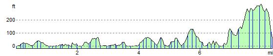
Elevation Profile