Gower Walks

Explore the wonderful Gower AONB on this series of coastal walks in Wales. In 1956, Gower became the first area in the United Kingdom to be designated an Area of Outstanding Natural Beauty. It is a fantastic area for walking with miles of coastal paths, beautiful bays and national nature reserves with sand dunes, lakes and a variety of coastal flora and fauna.
Use the links to view full route information including elevation profiles, interactive maps and GPS downloads.
You can also view an overview map of all the routes in the using the Gower Walk Map>>
| Route Name | Photo | Distance | Description |
| Bishopston Valley | 2 miles (3 km) | This walk takes you through a beautiful wooded valley to the stunning beach at Pwll Du Bay. It's a delightful tranquil area with the running water of the river and interesting flora and fauna. The walk starts in Kittle and follows footpaths south through the Bishopston Valley. The paths runs along the river which is surrounded by woodland and little caves. You continue through wet meadows grazed by cattle and home to various wildflowers before coming to the delightfully secluded Pwll Du Bay. Here you can enjoy a stroll along the beach and take in the wonderful coastal views of the Gower. If you would like to continue your walking in the area then you could head a mile or so west and visit the ruins of Pennard Castle and explore the beautiful Pennard Burrows. If you head east along the coast towards Swansea you can visit the lovely beach at Caswell Bay and explore the popular Mumbles where there are more nice coastal walking paths. View Full Details>> | |
| Cefn Bryn | 7 miles (12 km) | This super walk in the Gower AONB takes you along an elevated sandstone ridge known as the 'backbone of Gower'. With a high point of 188m/617 ft the walk is quite challenging but you are rewarded with wonderful views of the coastline and countryside of the Gower Peninsula. The walk starts in the little village of Penmaen where there is parking at the National Trust car park. You then pick up the good footpath along the ridge with wonderful views back to Oxwich Bay. You continue towards Cefn Bryn Common and to the neolithic burial ground of Arthur's Stone. Its name comes from a legend that the ancient British King Arthur threw a large stone from Llanelli which landed on this spot. Look out for Wild ponies and horses in this area. There is also the Broad Pool nature reserve consisting of a large pond which attracts wildlife such as dragonflys and wetland birds. At the summit point there is a handy toposcope detailing all the landmarks that can be seen from the hill top. This walk descends back to Penmaen from Arthur's Stone but you could continue along the ridge to Ryer's Down and Llanmadoc where you will find the splendid Whiteford Sands Nature Reserve. Here you will find woodland and sand dunes with nice coastal views to the lighthouse at Whiteford Point. The Three Cliffs Bay Walk also starts from Penmaen. View Full Details>> | |
| Gower Way | 35 miles (56 km) | This walk takes you through the stunning Gower AONB from Penlle'r Castell in the north, to Rhossili on the Gower Peninsula, in the south. The route was inaugurated by the Prince of Wales in 1998 and takes you past a variety of impressive historical sites, including ancient cairns, standing stones and Norman chapels. The first section runs from Penlle'r Castell to Gowerton, passing the Lliw Reservoirs, before crossing the River Lliw a Gorseinon. The second section runs from Gowerton to Penmaen where you can enjoy splendid coastal views of Oxwich Bay. The final section runs from Penmaen to Rhossili, with a climb to the sandstone ridge of Cefn Bryn where there are more fabulous views of the Gower Peninsula. At Rhossili you can enjoy wonderful views over Rhossili Bay and Worm's Head. This unusual promontory, is shaped like a giant sea-serpent and marks the most westerly tip of Gower. It is possible to walk to Worm's Head but only when the tide is out so check tide times before if you intend to extend your walk here. The walk is waymarked with a black, green and yellow disc. View Full Details>> | |
| Llangennith | 5 miles (7.8 km) | This Welsh village is located in a wonderful spot on the Gower Peninsula. There's excellent trails to follow through the surrounding dune system with hill climbs and great sea views to enjoy as well. View Full Details>> | |
| Llanmadoc | 7 miles (11 km) | This walk from the village of Llanmadoc visits Cwm Ivy, Llanmadoc Hill and the neighbouring village of Cheriton. There's much to enjoy on the route with beaches, saltmarsh and wonderful views from the high points. View Full Details>> | |
| Llanrhidian | 5 miles (8.8 km) | This North Gower based village has some nice trails along the marshland and Loughor estuary. View Full Details>> | |
| Lliw Reservoir | 2 miles (3 km) | This is a nice walk between Lower Lliw Reservoir and Upper Lliw Reservoir, using a section of the Gower Way long distance trail. It's about a 2 mile walk between the reservoirs, so 4 miles there and back. It's a resonably flat road with a moderate climb towards the end as you approach the upper reservoir. Please take care on the road between the reservoirs as it is often used by vehicles from Welsh Water employees, residents and deliveries. The reservoirs are in a delightfully quiet spot with lovely views of the surrounding hills and countryside. Look out for wildlife including Canadian geese on the water. The walk starts of from the Lower Lliw Reservoir car park. There's also a visitor centre and cafe which sells a variety of cakes and snacks at reasonable prices. After leaving the car park you follow the trail north along the eastern side of the lower reservoir. It then continues along the Afon Lliw (River Lliw) to the upper reservoir. If you would like to extend your walk you can continue north along the Gower Way through the woodland at the upper reservoir to Penlle'r Castell where the trail actually starts/finishes. Here it links with St Illtyd's Walk which you can use to further explore the area. The site is located a few miles north of Swansea. View Full Details>> | |
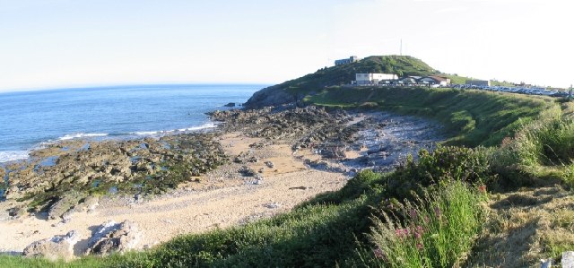
| Mumbles Circular | 3 miles (5.5 km) | This circular walk takes you around the Mumbles headland on the western edge of Swansea Bay, just south of Swansea. It starts by the bus station and information centre near Oystermouth Castle. It's well worth exploring the ruins of the 12 century Norman Castle before starting the coastal walk. There are lovely views over the bay from the castle grounds. You head along the coast to Mumbles Head where there is a lifeboat station and a nice long pier to stroll out on. From here there are great views out to Mumbles Head and the lighthouse. You continue along the coast, passing Bracelet Bay and Limeslade Bay before heading to the lovely Langland Bay. There's a nice beach here and great views down the Gower coast. If you'd like to extend your walk you could continue along the Gower coast on our Mumbles to Langland and Caswell Bay Walk where you'll visit a lovely beach popular with tourists and surgers. Just beyond Caswell Bay there's the delightful Bishopston Valley and the beautiful secluded beach at Pwll Du Bay. View Full Details>> | |
| Mumbles to Langland and Caswell Bay Walk | 4 miles (6.5 km) | This walk takes you from the Mumbles to the lovely Caswell Bay on the south east of the Gower Peninsula. The route runs for a distance of just over 4 miles on a undulating coastal path, passing Langland Bay on the way. The walk starts from the information point near Oystermouth Castle in the Mumbles. You can then follow the coast path south to Mumbles Head and Limeslade. The route then turns west to take you past Bracelet Bay, Limeslade Bay, Langland Bay and Whiteshell Point before coming to Caswell Bay. Here you'll find a beautiful beach popular with tourists and surfers. The bay has good facilities with two cafes, which are open all year round, toilets and a beach shop. Just behind the beach there are some nice woodland trails to try in Bishop's Wood. The nature reserve includes limestone woodland and interesting flora and fauna. You can return on the same paths to the Mumbles or there is a bus that can take you back if you prefer. View Full Details>> | |
| Oxwich Bay Circular | 4 miles (6.5 km) | This circular walk explores the area surrounding Oxwich Bay on the Gower Peninsula. The Travel Magazine named Oxwich beach the most beautiful in Britain. You start at the car park in Oxwich and head along the coast through Oxwich Wood before continuing to Oxwich point where there are splendid coastal views. On the way you will pass the fascinating St Illtud's Church. Founded in the 6th century the church has an interesting stone font and tranquil grounds. From Oxwich point you continue around the southern part of the headland with views over Port-Eynon Bay. Footpaths through the countryside then take you back to Oxwich via the fine ruins of Oxwich Castle. The route then heads through the lovely sand dunes of Oxwich Burrows Nature Reserve where you can look out for a variety of flora and fauna. These include more than 600 species of plants such as Bee Orchids and Early Marsh-orchids. The area also includes a freshwater lake, salt marsh and the pretty stream of Nicholaston Pill. Look out for birds including Cetti's Warblers, Sedge Warblers and Bittern. If you'd like to continue your exercise then you could try the Three Cliffs Bay Walk which visits Nicholaston Burrows and Penmaen Burrows. The video below shows a walk from Oxwich to Three Cliffs also. The atmospheric ruins of the 12th century Pennard Castle are near here and well worth a visit too. View Full Details>> | |
| Oxwich to Port Eynon | 6 miles (10 km) | A lovely coastal walk from Oxwich to Port Eynon on the Gower coast. It's a splendid stretch of coast with gorgeous beaches and some excellent views from the high points on the trail. View Full Details>> | |
| Penclawdd | 5 miles (8 km) | This Welsh village is located on the north of the Gower Peninsula. The area is great for walking with coastal paths along the Loughor Estuary where you can look out for a wide variety of wading birds. The village is famous for its centuries old cockle industry with the cockles sold all over the world. View Full Details>> | |
| Pennard Castle | 4 miles (6 km) | Visit this ruined 12th century castle and explore the beautiful Pennard Burrows on this circular walk on the Gower Peninsula. It's a stunning area with a wooded valley and the fresh water river of Pennard Pill. The walk starts from the large parking area at West Cliff and heads along the coast to Shire Combe with wonderful views over Three Cliffs Bay (you can actually explore this section of the coast path on the google street view link below). There are nice wide grassy footpaths through fields surrounded by gorse bushes on this section. You then head through Pennard Burrows to Pennard Castle, crossing the delightful Pennard Pill on the way. The walk continues to the ruins on sandy paths. The castle is a grade II listed building and a scheduled ancient monument with a fascinating history stretching back several centuries. There's great phot opportunities with the beautiful coast making a splendid backdrop to the atmospheric ruins. If you would like to extend your walking in the area then you could try the Three Cliffs Bay Walk for more fabulous views. You could also pick up the Gower Way long distance walk or climb the sandstone ridge of Cefn Bryn for magnificent views over the area. Just a mile to the east is the lovely Bishopston Valley with a pretty river running through a wooded valley to Pwll Du Bay. View Full Details>> | |
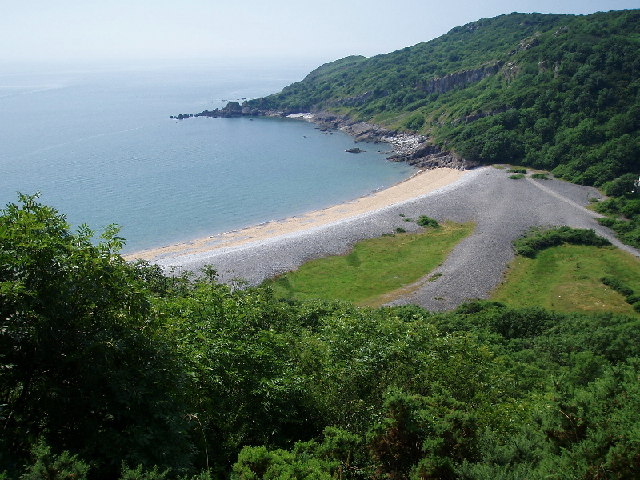
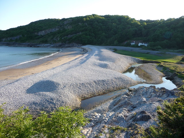
| Pwll Du Circular Walk | 4 miles (5.8 km) | This circular walk explores the area around the National Trust's Pwll Du Bay on the Gower Peninsula. View Full Details>> | |
| Rhossili | 2 miles (4 km) | This circular walk takes you around the Rhossili headland on the beautiful Gower Peninsula. The walk start from the car park in the village of Rhossili. Here there is a National Trust shop in one of the former coastguard cottages. You then follow a good surfaced footpath along the headland with wonderful views of the beautiful Rhossili Bay and beach. You continue towards Kitchen Corner where there are splendid views of Worm's Head. This unusual promontory, is shaped like a giant sea-serpent and marks the most westerly tip of Gower. It is possible to walk to Worm's Head but only when the tide is out so check tide times before if you intend to extend your walk here. The route continues along the coast to Tears Point with views of the lovely Fall Bay. The final section takes you through the countryside back to the car park. If you would like to continue your walking in the area then you could climb to the high point of the Gower at Rhossili Down on our Rhossili Bay Walk. The Gower Way long distance walk starts in Rhossili so you could follow the trail inland and visit the wonderful Cefn Bryn, an elevated sandstone ridge known as the 'backbone of Gower'. You could also pick up the Wales Coast Path and follow it north along Rhossili Bay to Llangennith. Using the google street view link below you can virtually explore area! View Full Details>> | |
| Rhossili Bay | 3 miles (5.5 km) | A circular walk taking you along the beautiful Rhossili Bay before a climb to Rhossili Down for wonderful views along the Gower Coast. The first section takes you along the Wales Coast Path from the Rhossili car park to Hillend. It's a fairly flat path running along the stunning Rhossili beach with nice views of the sand dunes and the cliffs. There is a campsite and a cafe at Hillend so it's a good opportunity to grab some refreshments at what is roughly the half way point of the walk. At Hillend you turn around and climb onto Rhossili Down, the highest point in the Gower. It's a beautiful area commanding fabulous views to Worm's Head. You can also see lots of pretty wildflowers on the heathland in the summer months. Look out for ponies and horses grazing on the Down too. At the beacon you will reach the high point of the Gower at 193m (633ft). It is also the site of a Bronze-Age cairn built around four thousand years ago. After taking in the views from the beacon the route descends a short distance back to the car park. To continue your walking in this stunning area you could try our circular walk around the Rhossili headland. At low tide you can also cross the causeway and visit Worm's Head. View Full Details>> | |
| Rhossili to Port Eynon Walk | 7 miles (11 km) | This walk follows a section of the Wales coast path from Rhossili to Port Eynon on the Gower. View Full Details>> | |
| Three Cliffs Bay | 4 miles (6 km) | This circular walk visits the stunning Three Cliffs Bay on the Gower Peninsula before exploring the adjacent woodland of Nicholaston Burrows. It's an exceptionally beautiful area with the view over Three Cliffs Bay nominated for 'Britain's Best View' in a recent television programme. The area includes sand dunes, salt marsh and the signature three limestone cliffs. The lovely stream of Pennard Pill also flows into the middle of the bay. You can continue your walk along the cliff top to the pretty Nicholaston Burrows where you will find woodland trails and interesting flora such as bloody cranesbill, pyramidal orchids and a number of lichen species.
This circular walk starts in the little village of Penmaen and descends to Penmaen Burrows where you will find the remains of a Neolithic burial chamber and a medieval church. You then head west to Nicholaston Burrows, passing the Nicholaston Pill stream and enjoying great views over Oxwich Bay. If you would like to continue your walking in the area then you could pick up the Gower Way long distance walk or climb the sandstone ridge of Cefn Bryn for magnificent views over the area. The Pennard Castle Walk will take you to the nearby ruins of a 12th century grade II listed building and scheduled ancient monument with a fascinating history stretching back several centuries. View Full Details>> | |
| Whiteford Sands | 4 miles (6 km) | This beautiful nature reserve on the North Gower coast has lovely walking trails through woodland and sand dunes with nice coastal views. View Full Details>> | |
| Worm's Head | 5 miles (8 km) | Visit this spectacular promontory in Rhossili on this wonderful coastal walk on the Gower Coast. Worm's Head is shaped like a giant sea-serpent and marks the most westerly tip of Gower. It's a unique place and one of the most fascinating features of this beautiful area of Wales. Start your walk from the National Trust's car park at Rhossili, where there's a visitor centre with lots of information about the area. You can then pick up the coastal path to Kitchen Corner where you descend to the Worm's Head causeway. At low tide you can cross the causeway on foot to reach Inner Head. You can also see the remains of several shipwrecks, wood from the wreck of the Helvetia being the most prominent when looking north from Rhossili. The causeway is only exposed for about two and a half hours before and after low tide, so please check the tide times before attempting the walk. After crossing the causeway you climb up to Inner Head which stands at a height of 47 metres (154 feet). Continue west and you will come to the wonderful Devil's Bridge, a natural rock bridge leading to Outer Head. To extend your walking in the area you can try our Rhossili Circular Walk which takes you around the headland with wonderful views of the beautiful Rhossili Bay and beach. The Rhossili Bay Walk will take you along the beautiful beach before climbing to the high point of the Gower on Rhossili Down. The long distance Gower Way also passes through the area. You can follow it east and visit the wonderful Cefn Bryn, an elevated sandstone ridge known as the 'backbone of Gower'. View Full Details>> |