Gerrards Cross Walks
![]()
![]() This Buckinghamshire based town is in a nice location for exploring the Chiltern Hill AONB. There's also a pleasant local common and riverside trails along the River Misbourne which runs past the eastern side of the settlement.
This Buckinghamshire based town is in a nice location for exploring the Chiltern Hill AONB. There's also a pleasant local common and riverside trails along the River Misbourne which runs past the eastern side of the settlement.
The town is accessible by public transport with services running into London in about 20 minutes.
This short circular walk takes you around Gerrards Cross Common in the town. The walk starts on the common which is located just to the south of the train station in the town. There are then various footpaths you can follow around the common. Here you'll find two picturesque ponds and some nice woodland trails.
You can extend the walk by heading a little west of the common to vist Bulstrode Park. There are public footpaths heading west past the Grade II listed mansion which predates the Norman conquest.
Postcode
SL9 7QW - Please note: Postcode may be approximate for some rural locationsGerrards Cross Ordnance Survey Map  - view and print off detailed OS map
Gerrards Cross Open Street Map  - view and print off detailed map
Gerrards Cross OS Map  - Mobile GPS OS Map with Location tracking
Gerrards Cross Open Street Map  - Mobile GPS Map with Location tracking
Walks near Gerrards Cross
- South Bucks Way - The South Bucks Way runs from Coombe Hill near Wendover to Denham near Uxbridge for a distance of approximately 23 miles
- Amersham Circular Walk - This circular walk around the market town of Amersham visits the nearby village of Chalfont St Giles while exploring the attractive countryside of the Misbourne valley
- Chiltern Heritage Trail - Travel through the Chilterns Hills on this splendid circular walk and visit numerous delightful hamlets, villages and towns in Buckinghamshire
- Beaconsfield - This circular walk from Beaconsfield explores some lovely Chilterns countryside
- Hodgemoor Woods - These woods near the town of Amersham have some good footpaths and mountain bike trails to try.
You can start off at the car park on Bottrells Lane at the northern edge of the site - Chiltern Way - This is the original 125 mile circuit of the Chilterns AONB taking you through Hemel Hempstead, Chalfont St Giles, Marlow, Hambleden, Turville, Fingest, Bix Bottom, Ewelme, the Ridgeway, Stokenchurch, Great Hampden, Aldbury, the Dunstable Downs Country Park, Sharpenhoe Clappers and Harpenden
- Sarratt - This picture postcard village sits in a delightful spot in the Chess Valley in Hertfordshire
- Colne Valley Trail - Follow the Colne Valley Trail from Uxbridge to Rickmansworth and enjoy riverside and canalside walking or cycling.
The trails follows the Grand Union Canal and the River Colne while also passing a series of pretty Lakes including Lynsters, Stocker's and Batchworth Lake - Black Park Country Park - With over 10 miles of well signed cycling and walking tracks, Black Park is the ideal place for a great day out in the country
- Chalfont St Peter - This Buckinghamshire based village has some nice trails through the Colne Valley and into the surrounding Chiltern Hills.
- Chalfont St Giles - This pretty Buckinghamshire village sits in a nice rural spot on the edge of the Chilterns AONB.
- Langley Park Country Park - Langley Park has a variety of beautiful trails suitable for cycling and walking
Pubs/Cafes
The Bull Hotel is a good choice for some post walk refreshment. The hotel dates all the way back to 1688 when it was a coaching inn. Now there is an award-winning restaurant and bar with a fine menu to choose from. The Jack Shrimpton bar is named after a 17th century highwayman and includes a charming interior with a cosy fire, carved wooden bar and ceiling beams. The site also includes a beautiful landscaped garden area. You can find the hotel next to the common at postcode SL9 7PA.
Dog Walking
The common is a fine place for a dog walk so you'll probably see other owners on your visit. The Bull mentioned above is also dog friendly.
Further Information and Other Local Ideas
The South Bucks Way can be picked up a little to the north in the neighbouring village of Chalfont St Peter. If you follow it north it will take you into Amersham where you could try the Amersham Circular Walk.
For more walking ideas in the area see the Chilterns Walks and the Buckinghamshire Walks pages.
Photos
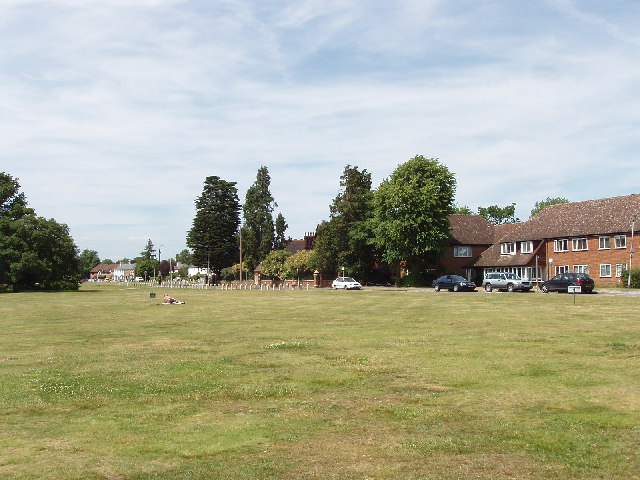
Gerrards Cross Common. This open space is just South of the town centre, taken looking West from East Common.
Woodland on Gerrards Cross Common. The common is partly open grassland and partly woodland with paths through. This photo is taken from the B416, between the A40 and the town centre.


