Napton on the Hill Circular Walk - Canal and Country
![]()
![]() This Warickshire based village is in a fine location for canal, country and lakeside walking. There's also some interesting buildings with a 12th century church and an old tower mill to see. After your exercise you can relax in the local canalside village pub.
This Warickshire based village is in a fine location for canal, country and lakeside walking. There's also some interesting buildings with a 12th century church and an old tower mill to see. After your exercise you can relax in the local canalside village pub.
This circular walk from the village takes you along the Oxford Canal to neighbouring Lower Shuckburgh before following country lanes back to the village.
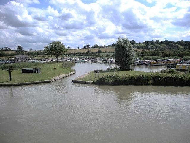
The walk starts in the village and follows footpaths north west towards Napton Hill and the windmill. Shortly after you link up with the canal and follow it east to Napton Marina and Napton Junction where the Oxford Canal links with the Grand Union Canal. You could take a detour here and head north to visit the pretty Calcutt Locks and marina. The Napton Reservoirs are also in this area.
This walk continues east to Nimrod Bridge and Lower Shuckburgh. Here you leave the canal and follow country lanes south east past the Shuckburgh Hills. The route then turns west to follow footpaths back into Napton.
For more information on the village including the historic parish church, economic and social history, the Napton Music Festival and Notable Residents please see the handy wikipedia entry.
Postcode
CV47 8NZ - Please note: Postcode may be approximate for some rural locationsNapton on the Hill Ordnance Survey Map  - view and print off detailed OS map
Napton on the Hill Open Street Map  - view and print off detailed map
Napton on the Hill OS Map  - Mobile GPS OS Map with Location tracking
Napton on the Hill Open Street Map  - Mobile GPS Map with Location tracking
Pubs/Cafes
The Folly pub is a nice place for some rest and refreshment after your walk. The old wood beamed pub sits in a fine location next to the canal. You can relax outside in the lovely waterside garden and watch the world go by. It's a friendly place with a good menu and selection of drinks. The pub can be found on Folly Lane with postcode CV47 8NZ for your sat navs.
Dog Walking
The country and towpath trails make for a fine dog walk. The Folly mentioned above is also dog friendly.
Further Information and Other Local Ideas
For more walking ideas in the area see the Warwickshire Walks page.
Cycle Routes and Walking Routes Nearby
Photos
Napton Junction-Wigram's Turn. Looking across the Oxford Canal from the bridge over the Grand Union Canal, towards the new Marina.


