Snowdon Rhyd Ddu Path Ridge Walk
![]()
![]() The Rhyd Ddu Path is one of the six main routes to the summit of the highest mountain in Wales. It is considered to be one of the quietest and most beautiful, though there are some challenging sections where care should be taken.
The Rhyd Ddu Path is one of the six main routes to the summit of the highest mountain in Wales. It is considered to be one of the quietest and most beautiful, though there are some challenging sections where care should be taken.
The path begins in the car park in the village of Rhyd Ddu and ascends to Pen ar Lon, Rhos Boeth and Llechog, before reaching the 1,085 metres (3,560 ft) summit. On the asent you will enjoy magnificent views of Llyn y Gadair and Llyn Cwellyn lakes, and the summits of Moel Hebog, Moel yr Ogof, Moel Lefn, Mynydd Drws y Coed and Mynydd Mawr. From the Snowdon summit there are views over Snowdonia, Ireland, the Isle of Man, the Peak District and the Lake District.
For an exhilarating circular ridge walk, taking in the Crib Goch ridge, try the Snowdon Horseshoe.
Snowdon Rhyd Ddu Path Ordnance Survey Map  - view and print off detailed OS map
Snowdon Rhyd Ddu Path Open Street Map  - view and print off detailed map
*New* - Walks and Cycle Routes Near Me Map - Waymarked Routes and Mountain Bike Trails>>
Snowdon Rhyd Ddu Path OS Map  - Mobile GPS OS Map with Location tracking
Snowdon Rhyd Ddu Path Open Street Map  - Mobile GPS Map with Location tracking
Explore the Area with Google Street View 
Pubs/Cafes
The Cwellyn Arms in Rhyd Ddu is the ideal place to enjoy a rest and a meal after your exercise. There are two cosy lounge areas with “real fires”, which are dog friendly. You can also relax and enjoy homemade food in the 40 seater restaurant with underfloor heating and log burning stove. The inn provides accommodation so is a good choice if you would like to stay over too. You can find it in the village at postcode LL54 6TL for your sat navs.
Further Information and Other Local Ideas
The climb to Mynydd Mawr also starts from the village. Follow the path north west and it will take you past Llyn Cwellyn to the summit where there are interesting geological formations, rocky outcrops and breathtakingly beautiful views to enjoy.
Just to the west of the village you can explore the Dorothea Quarry where you'll find the remains of the old mining houses and a series of scenic lakes including Llyn Nantlle Uchaf. The quarry is one of the significant sites on the Snowdonia Slate Trail which runs through the area. The circular long distance trail can be used to visit several of the other historic mining areas located in the World Heritage Site. Heading north along the trail would take you to Dinorwic Quarry which was at one time the second largest slate quarry in the world. The quarry is located on the edge of Padarn Country Park where there are some lovely waterside trails along Llyn Padarn and Llyn Peris.
For more walking ideas in the area see the Snowdonia Walks page.
Cycle Routes and Walking Routes Nearby
Photos

Snowdon from Rhyd Ddu

Rhyd Ddu path information board

Descending from Snowdon towards Rhyd-Ddu - the lake in the background is Llyn y Gader

Looking west from the western part of the square. This stile takes the path into the Snowdon open access area. The path thus leaves the open access area for a short time, only about 200 yards, before turning north and rejoining it. In the distance is Llyn Cwellyn.

Bwlch Main

Rhyd Ddu village. This village is seeing increased popularity following the reopening of the Welsh Highland Railway in the adjacent squares.

A gate on the path on a summer evening.

Path west of Pen ar Lon
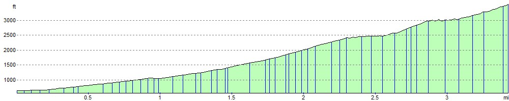
Elevation Profile