Donnington Way - Cotswolds Pub Walk
![]()
![]() Visit the 15 pubs of the Donnington Brewery on this super pub walk through the Cotswolds. The walk starts in Stow on the Wold and heads to a series of delightful Cotswold villages including the famous picture postcard settlement of Bourton on the Water.
Visit the 15 pubs of the Donnington Brewery on this super pub walk through the Cotswolds. The walk starts in Stow on the Wold and heads to a series of delightful Cotswold villages including the famous picture postcard settlement of Bourton on the Water.
You then pass through Naunton, Guiting Power and Snowshill where you can stop to visit the National Trust's Snowshill Manor. The next stop if the noteworthy village of Broadway where you can climb to the excellent viewpoint at Broadway Tower Country Park.
The route then heads to Chipping Campden, Blockley and Moreton-in-Marsh where you can try the Moreton-in-Marsh Circular Walk. Scroll down the page to view some of the fine old stone pubs you can stop off at on the walk.
Please click here for more information
Donnington Way - Cotswolds Pub Walk Ordnance Survey Map  - view and print off detailed OS map
Donnington Way - Cotswolds Pub Walk Open Street Map  - view and print off detailed map
*New* - Walks and Cycle Routes Near Me Map - Waymarked Routes and Mountain Bike Trails>>
Donnington Way - Cotswolds Pub Walk OS Map  - Mobile GPS OS Map with Location tracking
Donnington Way - Cotswolds Pub Walk Open Street Map  - Mobile GPS Map with Location tracking
Pubs/Cafes
One of the must see buildings on the route is Britain's oldest pub at the Porch House in Stow on the Wold. The inn has an interesting history dating all the way back to the 10th century when it was thought to have been a hospice built on on land belonging to Evesham Abbey. The interior has bags of old character with wonky ceilings and a very fine 16th century fireplace. They do excellent food and also provide accommodation if you need to stay over. There's also an outdoor area for finer days. You can find the historic inn on Digbeth Street with a postcode of GL54 1BN for your sat navs. It's also dog friendly if you have your canine friend with you.
Also in Stow is Donnington's Queen's Head. The fine old pub can be found on the square at GL54 1AB.
Other Donnington pubs on the route:
The Black Horse Inn, Naunton - dates back to 1870 and can be found at postcode GL54 3AD.
The Black Bear Inn, Moreton-in-Marsh - large restaurant and sky sports in this pub at postcode GL56 0AX.
The Farmers Arms, Guiting Power - good home cooked food in this traditional village pub. Postcode is GL54 5TZ.
The New Inn, Willersey, Broadway - another historic inn dating back to the 17th century. Postcode is WR12 7PJ.
Snowshill Arms, Snowshill - This traditional village pub dates back to the 15th Century and includes a skittle alley to the rear. They serve good food and also have a decent selection of local ales. Outside there's a lovely large garden area to relax in on warmer days. You can find them at postcode WR12 7JU for your sat navs.
Cycle Routes and Walking Routes Nearby
Photos

The Queen's Head, Stow market place. A delightfully unspoilt pub owned by the small Cotswold Donnington Brewery. All told the brewery has 15 pubs and there is a 62 mile Cotswold walk, known as the Donnington Way, which visits each of them. Notice also the royal connection in the pub name. Pretty well all the old pub names in Stow on the Wold have royal connections of one form or another, dating back to the time of the English Civil War when the town was staunchly Royalist.

Former Woodland between Longborough and Donnington. My OS map which is dated 2002 shows this large field as woodland, today, the wood, with the exception of a few mature trees has gone and the land is arable. The electronic OS version is correct. This view is from the Donnington Way.

The Black Horse Inn, Naunton

The Black Bear Inn, High Street, Moreton in Marsh. Some parts of the inn go back two or three hundred years supposedly but this is a far smaller establishment than the older coaching inns on High Street.

The Farmers Arms pub in Guiting Power, Cotswolds.

Chipping Campden-The Square

Snowshill Arms. The whole village seems to be a cohesive whole, in this tourist village, with the pub here lying opposite the church.

High Street, Blockley-geograph-2097537-by-David-P-Howard
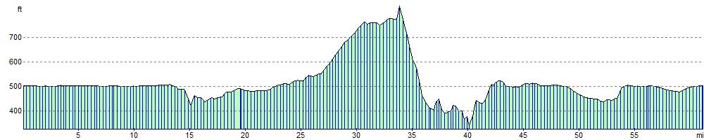
Elevation Profile