Harwood Forest Walk and Cycle

 Enjoy a largely traffic free cycle ride through Harwood Forest and the Simonside Hills in the Northumberland National Park. The route runs from Elsdon to Hepple and makes use of the Border County Ride cycle track which runs through the heart of Harwood Forest. The route starts in the village of Elsdon and passes Battle Hill, Fallowless Lough, Whitefield Hill and the River Coquet before arriving at Hepple. Return to Elsdon via the same route.
If you're looking for more cycle rides nearby then you could try the Kidland Forest cycle route which also makes use of the Border County Ride. You could also pay a visit to the pretty Fontburn Reservoir which lies just to the east.
Harwood Forest Ordnance Survey Map  - view and print off detailed OS map
Harwood Forest Open Street Map  - view and print off detailed map
Harwood Forest OS Map  - Mobile GPS OS Map with Location tracking
Harwood Forest Open Street Map  - Mobile GPS Map with Location tracking
Pubs/Cafes
In Elsdon there's the Bird in Bush Public House. They have a car park, garden area and restaurant. You can find them next to the village green at postcode NE19 1AA for your sat navs.
The cycle friendly Impromptu Cafe is just up the road and does a fine selection of cakes.
The attractive village is also worthy of exploration with an ancient church, a large village green, the remains of the old motte and bailey castle and a noteworthy Pele tower.
Further Information and Other Local Ideas
Head a few miles north west from the forest and you can pick up the circular Alwinton Walk. The route starts in the nearby little village and visits the River Alwin, River Coquet, the ruins of Harbottle Castle, West Wood and the excellent viewpoint at the Drake Stone. There's also a 12th century Norman church and a couple of classic old village pubs to visit in the area. From the village you can also pick up the circular Usway Burn - River Coquet - Upper Coquetdale Walk.
Head a few miles south of the woods and you'll find some pleasant woodland and waterside walking around Colt Crag Reservoir and Sweethope Loughs. These pretty lakes are also a good spot for wildlife watching with various wildfowl visitors to look out for on the water.
Just to the west is the village of Otterburn where you can visit the 9th century Otterburn Castle.
For more walking ideas in the area see the Northumberland Walks and the Northumberland National Park Walks pages.
Cycle Routes and Walking Routes Nearby
Photos

Forest road in Harwood Forest. Harwood Forest is a coniferous forest first established in the 1950s. Note the marshy vegetation in the ditch on the left hand side of the road.

Pit, Harwood Forest. Large amounts of road-making material are needed for forestry and this is presumably an old pit from which road-making material has been excavated.

A forest of Tuley Tubes, Harwood Forest. After clear felling, young saplings are routinely planted in these translucent tubes which protect them from deer until they reach an adequate height.

Redpath in the Harwood Forest

Clearing with purple heather in the forest.

Darden Rigg. Darden Rigg is a high ridge on the northern boundary of the forest.
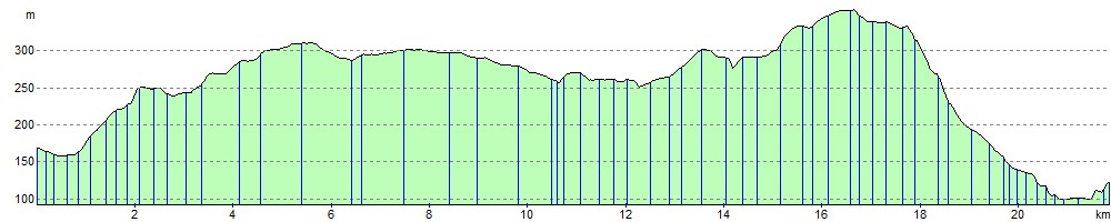
Elevation Profile