Kidland Forest
![]()
![]() Explore Kidland Forest and Upper Coquetdale on this circular cycle ride in the Northumberland National Park. You'll enjoy off road woodland tracks and a long riverside section on this varied ride.
Explore Kidland Forest and Upper Coquetdale on this circular cycle ride in the Northumberland National Park. You'll enjoy off road woodland tracks and a long riverside section on this varied ride.
The route starts near the parking area at Barrowburn and follows the Border County Ride off road cycle track into Kidland Forest. You then follow the track along the edge of the forest, passing Nettlehope Hill and Saughy Hill on the way. At Alwinton you pick up a country lane which takes you along the River Coquet to Barrowburn.
If you're looking for more cycle rides in the area then you could try the Harwood Forest cycle route which also makes use of the Border County Ride.
You could also explore further into Kidland Forest as it has a number of other super mountain bike trails.
Kidland Forest Ordnance Survey Map  - view and print off detailed OS map
Kidland Forest Open Street Map  - view and print off detailed map
Kidland Forest OS Map  - Mobile GPS OS Map with Location tracking
Kidland Forest Open Street Map  - Mobile GPS Map with Location tracking
Further Information and Other Local Ideas
Head south from the forest and you can pick up the Alwinton Walk. The route starts in the little village and visits the River Alwin, River Coquet, the ruins of Harbottle Castle, West Wood and the excellent viewpoint at the Drake Stone. There's also a 12th century Norman church and a couple of classic old village pubs to visit in the area. From the village you can also pick up the circular Usway Burn - River Coquet - Upper Coquetdale Walk.
The delightful villages of Elsdon and Otterburn are well worthy of a visit. The former includes an ancient church, a large village green, the remains of the old motte and bailey castle and a noteworthy Pele tower. The latter has nice trails along the pretty Otter Burn and the historic Otterburn Hall with its fine architecture and deer park.
For more walking ideas in the area see the Northumberland Walks and the Northumberland National Park Walks pages.
Cycle Routes and Walking Routes Nearby
Photos

River Alwin near Clennell. This view of the River Alwin is about 4km north of Alwinton at the point where the river leaves the edge of the Kidland Forest. The river is flowing south, that is to the right of the photo, and it joins the River Coquet at Alwinton. The name Alwin comes from a Celtic river name, Alwent, which means 'shining white'. The hill behind the river is The Dodd which rises to 322m.

Forest road, Kidland Forest near Clennell. This view shows the start of the access road through the Kidland Forest about 4km north of Alwinton. This man-made forest of 2,100 hectares (5,190 acres) lies within the Northumberland National Park and consists predominantly of sitka spruce planted between 1953 and 1987, of which just over half is owned by the Forestry Commission. The logging of trees started in the mid-1990s.

Firebreak, Wholhope Hill near Wether Cairn. This firebreak in spruce pine on Wholhope Hill is at the eastern edge of the Kidland Forest. Before the forest was planted during the 1950s to 1980s, this area would have been moorland.

Moorland near Wether Cairn 1. This view looking south-west is of featureless moorland dropping down to the Allerhope Burn valley with the eastern edge of the Kidland Forest on the right. The boulders in the foreground are some of the 'White Stones'. The Kidland Forest extends across the hills in the middle distance, with the farms and cottages of Kidlandlee in the clearing in the middle.

Allerhope Burn valley near Clennell 1. This view is looking north-east from a point about half way up this remote valley at a height of about 300m. In the background is Kidland Forest. Towards the top left of the picture but hidden amongst the gorse bushes, the tiny Wholhope Burn runs down to join the Allerhope Burn.

Allerhope Burn valley near Clennell 2. The remote valley of the Allerhope Burn, which flows into the River Alwin about 1/4km behind the camera, has no buildings other than sheepfolds. The burn however is first mentioned, as Halrehopeburne, in the records of Newminster Abbey, which was near Morpeth, as forming part of the boundary in a grant of land made by Richard de Umfraville in 1226. The lower part of the valley is a Site of Special Scientific Interest (SSSI). A permissive footpath runs up the valley to Wether Cairn at 563m, and this route forms part of the annual Alwinton Round 15m and 20m walks organised by the North of Tyne Search & Rescue Team.

Kidland Dean, Kidland Forest. The road through Kidland Forest in the River Alwin Valley

A sign for the Kidland Forest alongside the River Alwin. The forest is a conservation area for the threatened red squirrel due to its isolation, and absence of deciduous trees, particularly oak, which would attract grey squirrels. The road is used by logging lorries but it also provides access to isolated farms and cottages, used for holiday lets and as outdoor pursuit centres, at Kidlandlee and elsewhere in the forest. The path just beyond the cattle grid to the left is a public footpath up to Kidlandlee which is 3/4 miles away at a height of 390m.
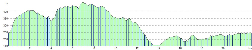
Elevation Profile