Belchford Walks
![]()
![]() This pretty village lies in the Lincolnshire Wolds, an Area of Outstanding Natural Beauty. There's some good footpaths including the epic Viking Way and a number of peaceful, flat country lanes.
This pretty village lies in the Lincolnshire Wolds, an Area of Outstanding Natural Beauty. There's some good footpaths including the epic Viking Way and a number of peaceful, flat country lanes.
This route uses part of the Viking Way and a series of country lanes to create a circular walk around the village. It's a long walk but very flat for nearly all the way. On the way you'll visit a series of neighbouring settlements and enjoy some lovely Wolds countryside.
The walk starts in the village where you can pick up the Viking Way and follow the waymarked footpath south to Fulletby, Low Toynton and the historic Roman town of Horncastle. There's some nice trails along the old Horncastle Canal and the River Bain to be found in this attractive town.
You then follow Hemingby Lane north to Furzehills and the village of Hemingby. From here you continue north along Green Lane to Goulceby where you pick up the Viking Way again. Follow the path south east and it will take you to Asterby House and Scamblesby before passing Juicetrump Hill and returning to Belchford.
Postcode
LN9 6LQ - Please note: Postcode may be approximate for some rural locationsBelchford Ordnance Survey Map  - view and print off detailed OS map
Belchford Open Street Map  - view and print off detailed map
Belchford OS Map  - Mobile GPS OS Map with Location tracking
Belchford Open Street Map  - Mobile GPS Map with Location tracking
Walks near Belchford
- Horncastle - This walk takes you along the old Horncastle Canal and the River Bain from the town centre of this Lincolnshire town.
- Woodhall Spa - Woodhall Spa is a very attractive former spa town on the edge of the Lincolnshire Wolds
- Tattershall Lakes - This waterside walk takes you along Tattershall Lakes and the River Bain in the Lincolnshire village of Tattershall.
The walk starts in the village centre on the River Bain, next to the remains of Tattershall Castle - Donington on Bain - This pretty village is located in the Lincolnshire Wolds AONB, on the banks of the River Bain
- Louth Canal - Enjoy a waterside walk along the Louth Canal from Louth to Tetney Marshes
- Tealby - This pretty village near Market Rasen is surrounded by some lovely rolling Lincolnshire Wolds countryside
- Willingham Woods - These woods near Market Rasen have miles of good footpaths and cycling trails to try.
- Covenham Reservoir - Enjoy a circular walk around this pretty reservoir and along the Louth Canal on this waterside walk in Lincolnshire.
- Market Rasen - This Lincolnshire based town is located in the West Lindsey district of the county
- Hubbard's Hills - This area of natural beauty in Louth is a lovely place for an afternoon stroll
- Alford - This small market town is located in a lovely spot on the edge of the Lincolnshire Wolds AONB
- Snipe Dales Country Park - Explore 220 acres of country park and nature reserve in the beautiful Lincolnshire Wolds
- Chambers Farm Wood - Enjoy a series of peaceful walking trails in this forest and nature reserve in Wragby
- Hagworthingham - This small Lincolnshire village is located in the East Lindsey district near Horncastle
- Biscathorpe - This Lincolnshire Wolds walk takes you from the medieval village at Biscathorpe to another medieval site at nearby Wykeham
- Goulceby - Goulceby is a Lincolnshire Wolds village located in the East Lindsey district of the county.
Pubs/Cafes
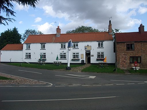
After your exercise head to the Bluebell Inn for some well earned refreshment. It's a traditional pub serving high quality dishes. They also have a garden area. You can find them on the Main Road at postcode LN9 6LQ for your sat navs.
Dog Walking
The country trails make for a fine dog walk. The Bluebell Inn mentioned above is also dog friendly.
Further Information and Other Local Ideas
Just to the north is the worthy village of Donington on Bain. Here you'll find nice views of the River Bain, a 12th century church and a fine 18th century pub. Near here there's also Biscathorpe, Binbrook and East Wykeham where there are the sites of two deserted medieval villages to explore.
In Goulceby you could take a small detour from the route to visit the splendid Red Hill Nature Reserve. There's a steep chalk escarpment with wonderful views and some rare plants and flowers to see here.
For more walking ideas in the area see the Lincolnshire Walks page.
Photos
Belchford. The building in the foreground houses the village post-office, behind that is the village pub, the Blue Bell and beyond that a care home which used to be the village school.


