Loddiswell Walk
![]()
![]() This Devon based village has some lovely walking trails to follow through the Avon Valley. There's also a noteworthy 14th century church and the old Loddiswell Railway Station to visit.
This Devon based village has some lovely walking trails to follow through the Avon Valley. There's also a noteworthy 14th century church and the old Loddiswell Railway Station to visit.
This circular walk from the village explores the surrounding countryside on a mixture of footpaths and country lanes. On the way there's some nice riverside paths along the River Avon and some pleasant woodland trails to enjoy.
The walk starts in the village and heads east to link up with the riverside footpath. Follow the path north and you can then cross over to the other side into Woodleigh Woods. It's a pretty place with the river running through the peaceful woods which include plenty of bluebells in the spring months.
The route then heads south past Wrinkley, Newmill Bridge and the remains of the old Loddiswell Rail Station. Near Culverwell you cross the river again and follow footpath north to return to the village.
You could extend the walk by heading a couple of miles south east to the neighbouring village of Aveton Gifford. Here you can pick up the Avon Estuary Walk, a long distance footpath which will take you to the coast at Bigbury on Sea where you could visit the lovely Burgh Island. Near here you can also link up with the Thurlestone and Bantham Walk. On this coastal walk you'll visit the National Trust's lovely South Milton beach, the striking Thurlestone Rock Arch and a great beachside seafood cafe.
For more information on the village including it's interesting history see the wikipedia page.
Postcode
TQ7 4QJ - Please note: Postcode may be approximate for some rural locationsLoddiswell Ordnance Survey Map  - view and print off detailed OS map
Loddiswell Open Street Map  - view and print off detailed map
Loddiswell OS Map  - Mobile GPS OS Map with Location tracking
Loddiswell Open Street Map  - Mobile GPS Map with Location tracking
Walks near Loddiswell
- Kingsbridge and Bowcombe Creek - Enjoy a circular walk to the lovely Bowcombe Creek from the popular market town of Kingsbridge in the South Devon AONB
- Salcombe and Bolt Head Circular Walk - This coastal circular walk takes you from Salcombe to the coastal headland at Bolt Head
- Prawle Point - Visit this wonderful coastal headland on this exhilarating walk in South Devon
- Bolberry Down - This easy circular walk explores the National Trust owned Bolberry Down on the Devon coast
- Gara Rock - This circular walk on the South Devon coast visits Gara Rock from East Portlemouth
- Bigbury on Sea - This attractive seaside village is located in the South Hams area of South Devon
- Avon Estuary Walk - This lovely circular walk explores both sides of the beautiful Avon Estuary in south Devon
- Burgh Island - Visit this beautiful island off the south coast of Devon on this lovely coastal walk
- Blackdown Rings - This walk visits an ancient Iron Age Hillfort and viewpoint in South Devon near Loddiswell.
- Erme Estuary - This circular walk explores the beautiful estuary of the River Erme as it meets the English Channel in South Devon
- Erme Plym Trail - Follow the Erme - Plym trail from Ivybridge to Laira Bridge on the outskirts of Plymouth on this pleasant walk through Devon
- Modbury - This large village in South Devon is a nice place to enjoy a stroll
- Aveton Gifford - This short circular walk explores the area around the little village of Aveton Gifford in Devon.
- Soar Mill Cove - This circular walk explores the beautiful Soar Mill Cove on the Devon Coast.
- Thurlestone to Hope Cove - This walk takes you along a lovely section of Devon coast from Thurlestone to Hope Cove.
Pubs/Cafes
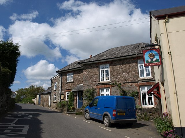
Back in the village you can enjoy post walk refreshment at the Loddiswell Inn. They serve good quality food and have a garden area. You can find them at postcode TQ7 4QJ for your sat navs.
Dog Walking
The country and woodland trails make for a fine dog walk. The local inn mentioned above is also dog friendly.
Further Information and Other Local Ideas
Just to the south you can try the Salcombe and Kingsbridge Estuary Walk or the Kingsbridge and Bowcombe Creek Walk. The estuary in the popular market town is a fine place for a stroll, with lots of boats and birdlife to see.
Just a couple of miles to the north there's the climb to Blackdown Rings. Here you'll find an Iron Age Hillfort commanding some excellent views over the surrounding area. The pretty Andrew's Wood Nature Reserve is located very close to the hill as well.
For more walking ideas in the area see the Devon Walks page.
Photos
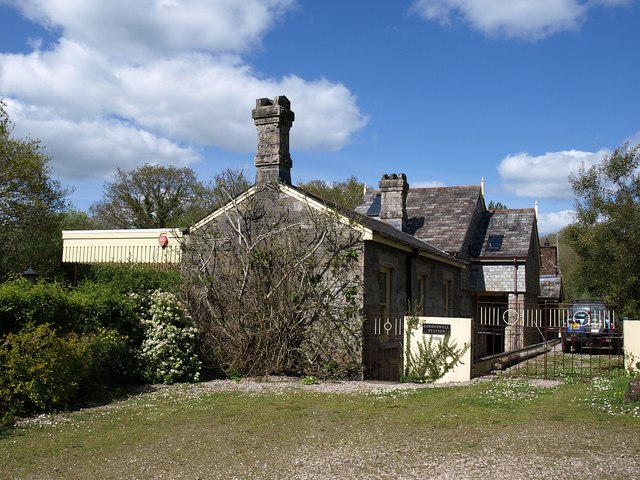
The old Loddiswell station. The station was closed in 1963; the buildings presumably date from 1893, the year the station opened. "Loddiswell was among the first sites to have Camping Coaches (The GWR called them 'Camp Coaches'). Old coaches were 'converted' to provide holiday accommodation and sited in sidings at attractive locations. You had to arrive by train, no great hardship in days before universal car ownership. Water was available from a stand-pipe at Loddiswell which was hardly convenient being at the far end of the station yard in the Cattle Dock. However at least an unending supply was available, at Avonwick the water had to be sent in Milk Churns by train. These were not particularly cheap holidays but must certainly have been very restful by any standard."
Approaching Loddiswell Mill Bridge. The bridge, across the River Avon, is on the left, on the lane to Loddiswell. But the buildings associated with the former mill, beyond the river, are now called "Avon Mill". The lane on the right continues to the former station, a full kilometre from the village as the crow flies, without all the turns in the lane.
Avon valley below Loddiswell. Taken from beside Great Gate Farm, at the junction of the old and new roads down the hill to the river, which is seen here below the Mill Bridge.
The 18th century Newmill Bridge. Looking across from the left bank of the River Avon, at the T-junction with the lane up the valley past the station. This lane was the former main road to the village.
By the Loddiswell Inn. Buildings by the inn (right) at the start of South Brent Road in the centre of the village.


