Wirral Way
![]()
![]() This is a terrific walk or cycle ride that runs along a pleasant traffic free path through the Wirral Countryside and along the coastal estuary of the River Dee. It follows the track bed of part of the former Birkenhead Railway route from Hooton to West Kirby.
This is a terrific walk or cycle ride that runs along a pleasant traffic free path through the Wirral Countryside and along the coastal estuary of the River Dee. It follows the track bed of part of the former Birkenhead Railway route from Hooton to West Kirby.
You start off at Hooton Railway Station near Ellesemere Port and head towards Neston entering the lovely Wirral Country Park on the way. The path then heads along the beautiful Wirral coastline passing Heswall and Thurstaston before finishing at West Kirby.
Along the route you'll pass very close to Royden Park and Caldy Hill, both of which are worth a small detour if you have time. At Royden Park you will find woodlands, meadows, heathland and two meres with an abundance of birdlife. You can also explore Thurstaston Common and climb Thurstaston Hill here.
At West Kirby you'll pass Caldy Hill where there are nice woodland trails and views over the River Dee, Hilbre Island and the Irish Sea.
Near Neston you pass the pretty coastal village of Parkgate which is well worth a visit. From the attractive coastal parade there are views across the marshland of the Dee and huge variety of birdlife to look out for.
The long distance Wirral Circular Trail also passes the area. Pick up this 37 mile trail to explore the rest of the peninsula.
Wirral Way Ordnance Survey Map  - view and print off detailed OS map
Wirral Way Open Street Map  - view and print off detailed map
Wirral Way OS Map  - Mobile GPS OS Map with Location tracking
Wirral Way Open Street Map  - Mobile GPS Map with Location tracking
Pubs/Cafes
In Heswall you could stop off at the Jug and Bottle. The attractive inn includes a cosy interior and fine menu. Outside there's a large decking overlooking the surrounding gardens with glimpses of the Dee Estuary and North Wales through the trees. You can find them on Mount Avenue with a postcode of CH60 4RH for your sat navs.
Further Information and Other Local Ideas
The Burton Marshes Greenway starts just south of Neston train station. The shared cycling and walking trail will take you south through the RSPB's Burton Mere Wetlands where you can look out for a wide variety of birdlife on the River Dee Estuary.
Part of National Cycle Route 56 runs along the trail. The signed Sustrans route runs from the city of Chester to Liverpool, passing the famous Albert Docks and Sefton Park on the way. The route could be used to extend your ride.
Cycle Routes and Walking Routes Nearby
Photos

On the path near Wilaston

Pond at Wirral Country Park

Hooton
.jpg)
Looking north west from the site of the former Thurstaston Station.

Little Neston

Bridge over the Wirral Way path. Unmistakeably railway style brickwork on the old bridge carrying a farm road over the former line, now used as the Wirral Way. A nameboard with 'Dungeon Bridge' is under the arch.
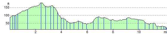
Elevation Profile