Llyn Peninsula Walks

The beautiful Llyn Peninsula extends 30 miles into the Irish Sea from north west Wales, south west of the Isle of Anglesey. It's a fabulous area for walkers with the Llyn Coastal Path taking you to a series of lovely bays, gorgeous beaches and pretty coastal villages.
Use the links to view full route information including elevation profiles, interactive maps and GPS downloads.
You can also view an overview map of all the routes in the using the Llyn Peninsula Walk Map>>
*New* - Walks and Cycle Routes Near Me Map - Waymarked Routes and Mountain Bike Trails>>
| Route Name | Photo | Distance | Description |
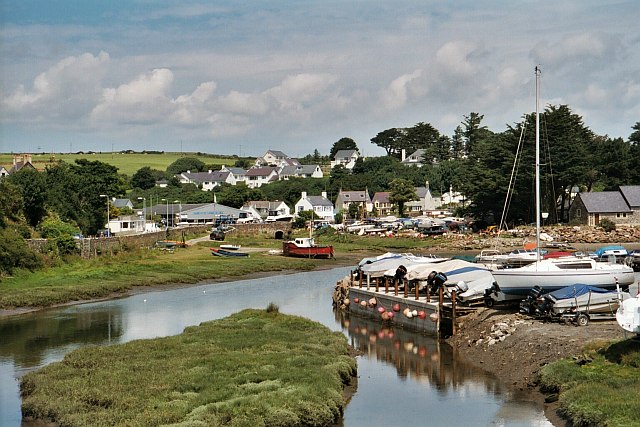
| Aberdaron | 6.2 miles (10 km) | This coastal Welsh village makes a great base for exploring the Llyn Peninsula on foot. This walk uses a section of the Llyn Coastal Path to create a circular route around the village. On the way you'll visit a fine coastal viewpoint and pass the area where the ferries depart to Bardsey Island. This walk starts in the village and follows the path west along the pretty beach and Aberdaron Bay. You then head south to Porth Meudwy where you can catch boats to Bardsey Island. The island has some nice walks and is a great place for birdwatching. You continue along the southern tip of the peninsula to Porth Felen and then onto Mynydd Mawr. At Mynydd Mawr the picnic site has views which, on a fine day, take in Cardigan Bay, Bardsey Island and the Wicklow Mountains. The old coastguard hut here includes an exhibition to the natural history of the area, and a mural created by local children. At Porth Llanllawen you leave the coast to head east through the countryside on footpaths and country lanes. The paths will take you back to Porth Meudwy where you can rejoin the coast path and return to the village. View Full Details>> | |
| Abersoch | 11.2 miles (18 km) | This circular walk around Abersoch uses the Llyn Coastal Path to explore the beautiful beaches and bays to the south and west of the village. View Full Details>> | |
| Caernarfon | 7.8 miles (12.5 km) | This popular Welsh seaside town marks the start of the epic Llyn Coastal Path which takes you along the beautiful Llyn Peninsula. This walk uses part of the long distance trail and a section of a dismantled railway line to create a lovely circular walk around the town. The walk starts at the historic Caernarfon Castle in the town centre. The castle dates back to the 11th century and has a fascinating history. The route then crosses the Aber Swing Bridge which crosses the Afon Seiont. You then follow the coast path south to Llanfaglan where you will pass the noteworthy St Baglan's Church. The Grade I listed building dates from the 13th century with a lintel consisting of a 6th-century inscribed stone positioned over the doorway. The route then runs along the lovely Foryd Bay which is also a nature reserve with lots of birdlife to look out for. It is located at the south-western end of the Menai Strait and includes large areas of mudflats and salt marsh. Keep your eyes peeled for waders and wildfowl including brent goose, jack snipe, spotted redshank and greenshank. The walk then leaves the coast to head east through the countryside to Dinas. There is a train station here on the Welsh Highland Railway which you could catch back into Caernarfon if your legs are weary. This route picks up the Lon Eifion shared walking and cycling trail which follows a disused railway path north. You'll cross the Afon Gwyrfai before returning to Caernarfon. View Full Details>> | |
| Criccieth | 5 miles (8 km) | This circular walk explores the coast and countryside surrounding the town of Criccieth in the Eifionydd area of Gwynedd. On the way you'll visit the historic Criccieth Castle and the grave of former Prime Minister David Lloyd George. View Full Details>> | |
| Dinas Dinlle Coastal Walk | 2.5 miles (4 km) | This walk visits the ancient hillfort and beautiful beach at Dinas Dinlle in Gwynedd, north-west Wales. There is a car park in the village just north of the site. From here you can follow footpaths south up to the fort before heading north along the coast to the nearby Caernarfon Airport. View Full Details>> | |
| Garn Boduan | 3.1 miles (5 km) | This walk takes you up to the Iron Age Hill fort of Garn Boduan on the Llyn Peninsula near Nefyn. View Full Details>> | |
| Garn Fadryn | 1.1 miles (1.8 km) | This walk climbs to the remote Iron Age Hillfort at Garn Fadryn in the Llyn Peninsula . View Full Details>> | |
| Llanbedrog | 4 miles (6.5 km) | This pretty Welsh village is located in a lovely spot on the south side of the Llyn Peninsula. View Full Details>> | |
| Llanystumdwy | 3.2 miles (5.2 km) | This little Welsh village is located in a fine spot on the Llyn Peninsula near Criccieth and Pwllheli. View Full Details>> | |
| Llyn Coastal Path | 80.8 miles (130 km) | Follow the Llyn Peninsula from Caernarfon to Porthmadog on this stunning coastal walk. The route is often completed in 7 sections: Caernarfon to Trefor Trefor to Morfa Nefyn Morfa Nefyn to Llangwnnadl Llangwnnadl to Aberdaron via the fine beaches and viewpoints at Whistling Sands and Porth Iago Aberdaron to Abersoch Abersoch to Pwllheli Pwllheli to Porthmadog As well as the stunning scenery you can look out for bottle-nosed dolphins and Atlantic grey seals as these are often seen off the coast. Near Trefor you can enjoy wonderful views of the three peaks of Yr Eifl and the fascinating hill fort at Tre'r Ceiri. There's also a visit to the historically significant castle in Criccieth. View Full Details>> | |
| Lon Eifion | 11.2 miles (18 km) | This splendid cycling and walking trail runs along a disused railway path from Caernarfon to Bryncir on the edge of the Snowdonia. It's a good surfaced traffic free path making it ideal for a safe family cycle or a leisurely walk. There are lovely views of the surrounding Welsh Countryside and mountains such as Yr Eifl (or the Rivals) and Snowdon. The route runs alongside the Welsh Highland Railway so you should also see some wonderful steam trains as you go. The route starts at Caernarfon at the impressive Caernarfon Castle, and heads south through the town, crossing the River Seiont on the way. You continue to Llanwnda and Groeslon where you pass the lovely Glynllifon Country Park. It's well worth taking a short detour from the path and visiting the park with its woodland, gardens, parkland and river. There is also a cafe, a maze and exhibits such as steam power pistons restored by Fred Dibnah. The route continues through Penygroes before the final stretch takes you to the finish point at the little village of Bryncir. View Full Details>> | |
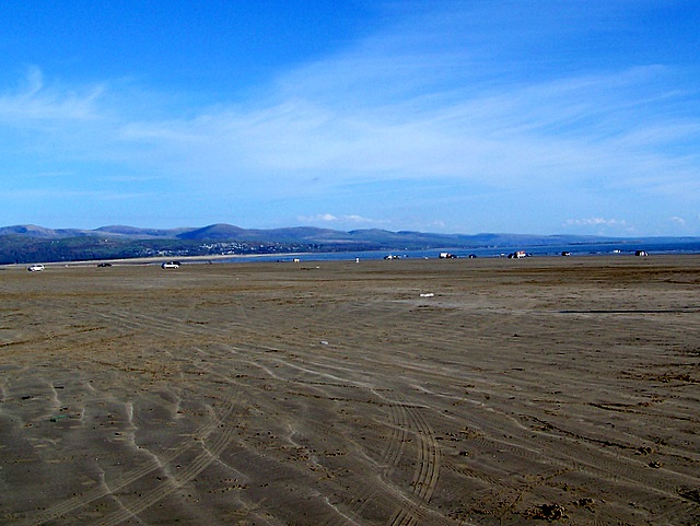
| Morfa Bychan | 3.7 miles (6 km) | This delightful village is located on the Llyn Peninsula in Gwynedd. The village is well known for its splendid long beach which stretches for two miles from Ynys Cyngar on the River Glaslyn estuary along Tremadog Bay to Criccieth beach. View Full Details>> | |
| Nant Gwrtheyrn | 4 miles (6.4 km) | This Welsh Language Heritage Centre is located near the village of Llithfaen on the wonderful Llyn Peninsula. View Full Details>> | |
| Nefyn | 5.6 miles (9 km) | This small coastal town is located in a lovely spot on the Llyn Peninsula. It's great for walkers with a pretty harbour, miles of cliff top coastal paths and beautiful beaches to explore. View Full Details>> | |
| Plas yn Rhiw | 2.2 miles (3.5 km) | This walk takes you to this National Trust owned 17th century manor house in Rhiw, Gwynedd. View Full Details>> | |
| Porth Iago | 1.1 miles (1.8 km) | This walk explores the area around Porth Iago on the Llyn Peninsula. View Full Details>> | |
| Porthdinllaen | 2.5 miles (4 km) | Enjoy stunning coastal views and delightful coastal villages on this walk on the Llyn Peninsula. There are also fine sandy beaches, interesting rock pools and great views to the mountains of Yr Eifl and Snowdonia to enjoy on this bracing walk. The walk starts from the car park at the little village of Morfa Nefyn. You then walk along the attractive headland to the fishing village of Porthdinllaen where you will find the well known Ty Coch Inn. The distinctive pub is considered one of the best in Wales with its wonderful views over the Irish Sea to The Rivals. You continue around the headland passing the lifeboat station and heading through the local golf course before returning to the car park. The area is wonderful for wildlife. Look out for a variety of sea birds including oystercatchers, sand martins and cormorants. Grey seals can also be seen around the coast. View Full Details>> | |
| Pwllheli | 3.4 miles (5.5 km) | This circular walk takes you around the town of Pwllheli on the Llyn Peninsula. On the walk you'll visit the harbour, beach, the River Rhydir and the Lon Cob Bach Nature Reserve. Pwllheli is considered the the main town of the peninsula, with a train station and a range of shops and other services. The walk starts from the train station and heads south to the front where there are two blue flag beaches. You then head west along the beach before following a footpath north to the River Rhydir and the Lon Cob Bach Nature Reserve. There's some nice walkways here with interesting flora and fauna to look out for. You continue east through the town to the Inner Harbour where there's a nice path to follow to South Beach. You then retrace your steps to return to the train station and the finish point of the walk. View Full Details>> | |
| Trefor Quarry | 1 mile (1.6 km) | This walk visits the Yr Eifl Quarry in the coastal village of Trefor on the Llyn Peninsula, Gwynedd. View Full Details>> | |
| Trer Ceiri | 3.2 miles (5.1 km) | This walk climbs to the Iron Age Hillfort of Tre'r Ceiri on the Llyn Peninsula in Wales. It's about a 1.5 mile walk from the conveniently located car park near the village of Llithfaen. In total it's 3 miles there and back with a moderate climb, so a reasonable level of fitness is required. View Full Details>> | |
| Whistling Sands | 3.1 miles (5 km) | This circular walk visits Traeth Porthor or Whistling Sands on the Llyn Peninsula. The beach is a popular place with crystal turquoise water and golden sands flanked by steep cliffs. The walking route below additionally climbs to the fine viewpoint on Mynydd Carreg above the beach. View Full Details>> | |
| Yr Eifl | 3.7 miles (6 km) | Climb the Yr Eifl mountain group on this challenging circular walk on the Llyn Peninsula. The three summits are collectivley known as 'The Rivals' offering wonderful views over the Llyn Peninsula coastline, the Isle of Man, the mountains of Ireland and the Lake District, as well as the entire sweep of Cardigan Bay. The route visits the peak of Tre'r Ceiri where you will find Britain's best preserved Iron Age hill fort. The walk starts from the Porth-y-Nant upper car park just off the B4417 north of Llithfaen. You then ascend past the Graig Ddu cliffs where you can look down and see the abandoned village of Borth y Nant. You continue to Bwlch yr Eifl where you turn east towards the 561 m (1,841 ft) summit of Yr Eifl. It's a stunning spot. Take a while to soak in the magnificent views of the coast and mountains of Snowdonia. The footpath then descends to Tre'r Ceiri where you can explore the interesting Iron Age stone hut circles before descending the mountain. If you would like to continue your walking in the area then you could pick up the Llyn Peninsula Coastal Path which runs past the mountain. View Full Details>> |