Kent Downs Walks

This Area of Outstanding Natural Beauty is located on the eastern section of the North Downs and stretch from the London/Surrey borders to the White Cliffs of Dover. They are a walkers paradise with miles of waymarked trails taking you to lovely hill tops with views across the Downs to the coast.
Use the links to view full route information including elevation profiles, interactive maps and GPS downloads.
You can also view an overview map of all the routes in the using the Kent Downs Walk Map>>
*New* - Walks and Cycle Routes Near Me Map - Waymarked Routes and Mountain Bike Trails>>
| Route Name | Photo | Distance | Description |
| Ashenbank Wood | 2.2 miles (3.5 km) | This walk visits Ashenbank wood near Cobham and Gravesend. View Full Details>> | |
| Ashford | 10.6 miles (17 km) | This Kent town is ideally positioned for walkers on the edge of the Kent Downs and the North Downs. There are also nice waterside paths along the river Great Stour which runs through the centre of Ashford. This route uses sections of the Stour Valley Walk and the North Downs Way to take you up to the splendid Wye Downs just to the north east of the town. On the way you'll enjoy riverside paths along the River Stour, visit the lovely village of Wye and enjoy wonderful views over the area from the high points on the Wye and Broad Downs. View Full Details>> | |
| Barham | 9.9 miles (16 km) | This pretty village is located within the Kent Downs AONB, just south of Canterbury. The village includes a 14th century church and the 17th century and Broome Park, a Grade I listed building with gardens. For walkers there are some fine trails taking you through the North Downs and the Elham Valley. View Full Details>> | |
| Bearsted | 5.6 miles (9 km) | This attractive Kent based village has a pretty village green, a local community run woodland park and easy access to the footpaths on the North Downs. View Full Details>> | |
| Boxley | 4.8 miles (7.7 km) | This little Kent based village is a pleasant place to start a walk. It's located right on the North Downs with some lovely rolling countryside, local woodland and an historic abbey to visit. View Full Details>> | |
| Canterbury Rivers and Woods | 9.9 miles (16 km) | This 10 mile circular walk takes you along the River Stour before visiting several local woods near the city. It uses sections of the Stour Valley Walk, the North Downs Way and the Canterbury Centenary Walk to take you on a tour of the countryside to the west of the famous cathedral city. View Full Details>> | |
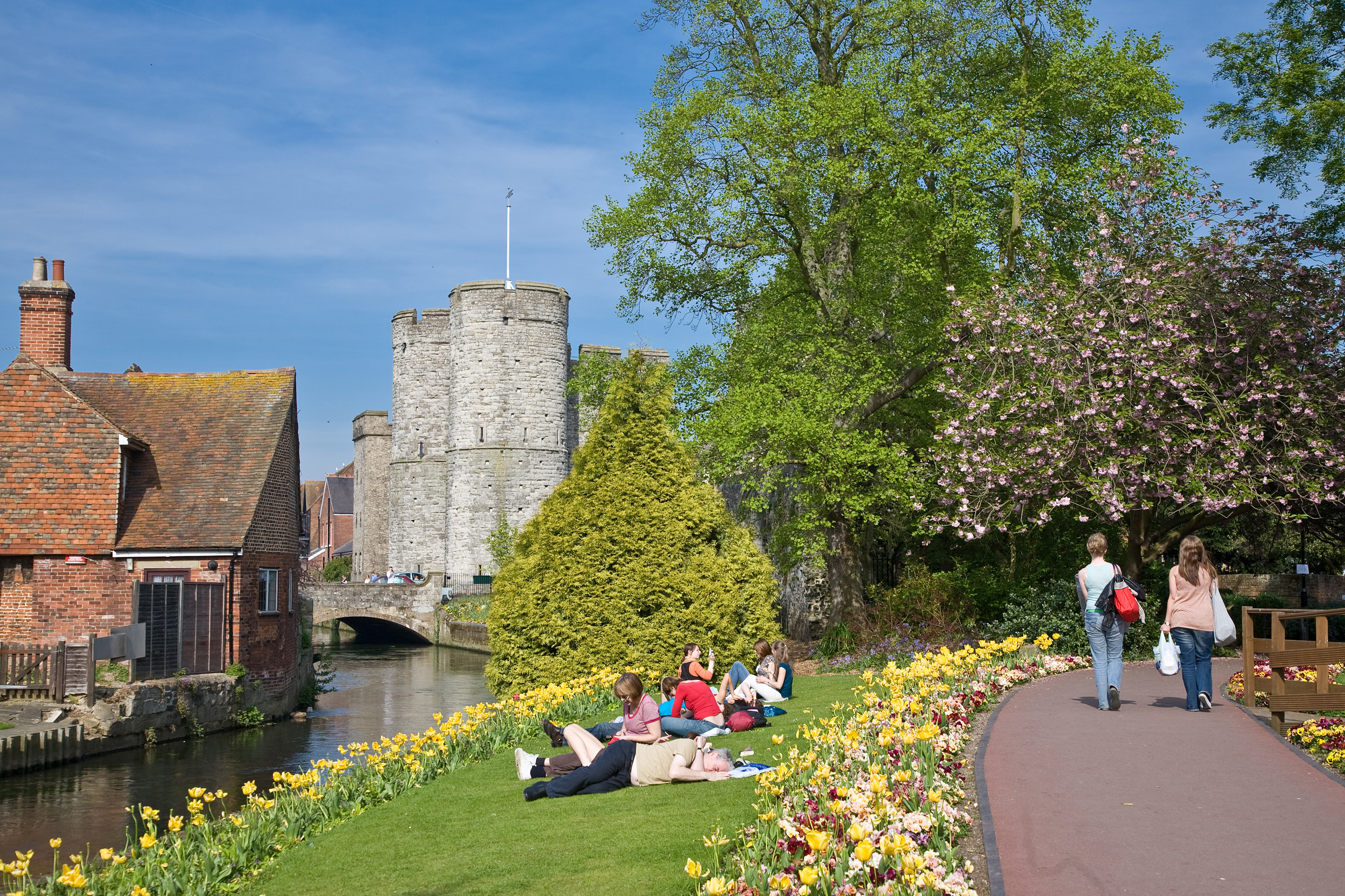
| Canterbury to Chartham Walk | 4.3 miles (7 km) | This is a popular walk from Canterbury to the nearby village of Chartham. The route uses a waymarked footpath along the River Great Stour to take you to the pretty village which is located about 4 miles to the west of the city. There's lovely countryside views, a series of pretty lakes and lots of pretty orchards to see on the way. The walk starts in the city centre next to the famous cathedral. From here you can pick up the Stour Valley Walk and follow it north through the city to the river. Here you'll enter the lovely Westgate Gardens which are the perfect place for a stroll in the city centre. It is situated alongside Westgate Towers, the city’s 600-year-old gatehouse, and has been a public open space since the Middle Ages, making it one of England’s oldest parks. The waymarked trail then heads west through the park, before passing Bingley's Island, Tonford Manor, Tonford Lake and Swan Lake. Shortly after you come into Chartham itself. The village is very picturesque with a weir and a 19th century corn mill by the river. At the end of the walk you can catch the train directly back to Canterbury or return on the same paths on foot if you prefer. Just before you reach Chartham you can take a small detour from the route to visit the Larkeyvalley Nature Reserve. There's some nice woodland footpaths here with lots of interesting flora and fauna to see too. To extend the walk continue west along the Stour Valley Walk to the village of Chilham with its pretty lakes and old watermill. View Full Details>> | |
| Canterbury to Dover Walk | 19.9 miles (32 km) | This walk takes you from the cathedral city of Canterbury to the famous port of Dover. The route runs for a distance of about 20 miles along a section of the North Downs Way. The route starts in the city centre near the famous cathedral, where you can pick up the North Downs Way. The waymarked path leads you south east towards St Augustine's Abbey which is worth a small detour from the path. The abbey ruins date from the 6th century and are now owned by English Heritage. The route then leaves the city and heads out into the countryside toward Patrixbourne and then onto the village of Bridge where you will pass the noteworthy Higham Park. Here you will find a Grade II listed neoclassical style house and gardens. The Palladian fronted house dates from the mid 18th century. The next stage takes you through Womenswold to Shepperdswell. At ashley you turn south toward Pineham before coming into Dover. Here you can extend your walk by visiting the fascinating Dover Castle or visiting the famous White Cliffs on the Dover Cliffs Walk. View Full Details>> | |
| Charing | 6.8 miles (11 km) | This circular walk explores the countryside around the Kent village of Charing. The historic settlement is a fine place to start a walk with lots of trails taking you into the surrounding countryside of the Kent Downs. The village itself is also very interesting with an old windmill, a 14th century church and the 13th century Archbishop's Palace to see. View Full Details>> | |
| Chilham | 3.7 miles (6 km) | This circular walk takes you around the Kent village of Chilham, visiting the River Great Stour, Chilham Lake and Denge Wood. It's a very picturesque place with pretty cottages and a noteworthy old manor house. The route starts in the delightful village centre near to Chilham Castle. The site includes a fine manor house which dates from the early 17th century and a Norman Keep. It is the oldest building in the village, dating from 1174 and is still inhabited - making it perhaps one of the oldest dwellings in the UK. From here you head east through the village toward Bagham before picking up paths along the Great Stour River. These lead you to the pretty Chilham lake which includes a beautiful 5-storey watermill and is a popular spot for fishing. At the eastern end of the lake you can pick up the Stour Valley Walk and follow it back towards the village. On the way you will skirt the edge of Denge Wood which is a nice place to extend your walk. The woods include a number of different type of orchid and are an important habitat for nesting and migratory birds including the nightingale, chiffchaff, and spotted flycatcher. After passing the woods the route returns to the village where you can enjoy refreshments at one of the two large pubs. This includes the Woolpack and the White Horse, the latter of which dates from the 16th century. View Full Details>> | |
| Cobham | 5.6 miles (9 km) | This village in Kent has some fine walking trails to try. This circular walk takes you to some of the highlights of the area including Cobham Park, Jeskyns Park and Shorne Woods Country Park. The walk starts in the village and heads east into Cobham Park. The area is run by the National Trust and includes woodland pasture and an 18th century Darnley Mausoleum. It was designed by James Wyatt for the 4th Earl of Darnley of Cobham Hall according to detailed instructions in the will of the 3rd Earl of Darnley. The site includes a tree trail with a collection of ancient and veteran trees which were formerly part of the Darnley Estate and deer park. The route then bends round to the north to visit Shorne Woods Country Park. Here you will find hundreds of acres of rolling woodlands, wetlands and meadows which can be explored on a variety of waymarked trails. After exploring the park, the route heads south past Ashenbank Wood before branching off to the west to visit Jeskyns Park. Here you'll find woodlands, ponds, orchards and wildflower meadows to explore. After leaving the park it is a short stroll back to Cobham village where the route finishes. The route passes close to Ranscombe Farm Country Park at the eastern fringes. View Full Details>> | |
| Conningbrook Lakes Country Park | 1.9 miles (3 km) | This country park and nature reserve is located close to the town of Ashford in Kent. View Full Details>> | |
| Darent Valley Path | 19.3 miles (31 km) | Travel through the Kent Downs AONB and along the Darent River on this beautiful walk or cycle. You start off near Sevenoaks Railway Station and head north through the delightful tranquility of the Sevenoaks Wildlife Reserve. The route continues towards Otford (with its 16th century Palace) and then onto Shoreham where you'll pass Lullingstone Country Park. As one of the oldest family estates in England (1497) Lullingstone Castle has an interesting history and attractive gardens making it well worth a visit. The next section takes you on to Eynsford and Farningham where the river is particularly attractive. This section passes Eynsford Castle and the pretty Farningham Woods Nature Reserve, which is worth a small detour from the path. From Farningham you enter the outskirts of London, passing Darenth Country Park and Dartford. View Full Details>> | |
| Denge Wood | 5.6 miles (9 km) | These attractive woods are located a few miles west of Canterbury, near the delightful village of Chilham, and on the dip slope of the North Downs and the Kent Downs AONB. There are miles of footpaths to follow around the site with a wide variety of flora and fauna to look out for on the way. This circular walk starts from Chilham where there is a train station just to the east of the village. From here you can follow footpaths south over the River Great Stour to the expansive woods. The site includes a number of different type of orchid and are an important habitat for nesting and migratory birds including the nightingale, chiffchaff, and spotted flycatcher. You may also see fallow deer and roe deer if you are fortunate. View Full Details>> | |
| Dering Woods | 1.9 miles (3 km) | These woods near Pluckley are also known as "Screaming" wood due to reports of paranormal activity in the area. If you can pluck up the courage there are some nice waymarked walking trails to try in the woods. Start the walk from the car park off Smarden Bell Road. From here you can pick up the trails heading south into the woods. Here you'll find ancient trees with wood anemones and pretty bluebells to see in the spring months. Look out for lots of different types of butterfly fluttering around the flours and nightingales flying through the trees above. As you make your way along the two waymarked trails look out for the King George Star. This footpath junction is the meeting of six paths within the wood and named after King George IV who was a visitor to the wood. View Full Details>> | |
| Detling Hill | 3.1 miles (5 km) | This walk climbs to Detling Hill, just to the east of the village of Detling in Kent. The hill is located in the Kent Downs area of the North Downs and provides fine views over the surrounding countryside from the summit. You can start the walk from Detling village and follow the North Downs Way east to Gorse Farm before picking up other paths to take you to the hill top which stands at a height of 200 m (660 ft). View Full Details>> | |
| Devils Kneading Trough | 1.2 miles (2 km) | The Devil’s Kneading Trough is a striking natural amphitheatre located near Wye in Kent, within the North Downs Area of Outstanding Natural Beauty. This dramatic dry valley is one of the finest examples of its kind in England, carved out over thousands of years by glacial meltwater. From the top, visitors are rewarded with sweeping views over the Kent Downs and the expansive Wye National Nature Reserve. On clear days, it is possible to see the English Channel and even the distant coastline of France. The surrounding landscape is characterised by rolling chalk hills, ancient woodlands, and vibrant wildflower meadows, making it a picturesque spot for walkers and nature enthusiasts alike. View Full Details>> | |
| Elham Valley Way | 21.7 miles (35 km) | Explore the Kent Downs Area of Outstanding Natural Beauty on this delightful railway walk through Kent. The route starts on the coast at Hythe and heads north to Canterbury via Elham and Barham. Highlights on the route include stretches through the seabrook valley near Hythe, ancient woodland (dating from before the 17th century), beautiful orchards, views of the Nailbourne river and the famous Cathedral at Canterbury at the end of the route. View Full Details>> | |
| Greensand Way | 107.5 miles (173 km) | The Greensand Way runs from Haslemere in Surrey to Hamstreet in Kent following the ridge of greensand rock that crosses the two counties. The route takes in two Areas of Outstanding Natural Beauty - the Surrey Hills and the Kent Downs - as well as numerous Sites of Special Scientific Interest. Highlights include
| |
| Harrietsham | 5.7 miles (9.2 km) | This circular walk explores the pretty bluebell woodland around the village of Harrietsham in the Kent Downs AONB. View Full Details>> | |
| Hothfield Common | 1.2 miles (2 km) | This area of common land is located near Ashford in the Kent Downs AONB. The area is also nature reserve consisting of Kent's last four valley bogs and one of its few remaining fragments of open heath with patches of acid grassland. It is criss crossed with some nice marked footpaths and covered with interesting flora including heather, cross-leaved heath, dwarf and common gorse, heath spotted-orchid. You can start your walk from the public car park on the eastern end of the site, off the A20 road. From here you can pick up the colour coded trails taking you west towards the bogs. On the way look out for birdlife such as Yellowhammers, White Throat and Willow Warblers. You can also see the Konik horses which are used to graze the Heathlands in order to keep down invasive vegetation like bracken and silver birch. The Greensand Way long distance footpath runs across the western side of the common. You could pick up the waymarked trail to further explore the area if you have time. Follow it west and it will take you to the village of Pluckley which is closely associated with the 'Darling Buds of May'. Heading south east will take you toward Godinton Park and then into Ashford itself. The Stour Valley Walk also runs close by and is another good option. View Full Details>> | |
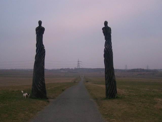
| Hucking Estate | 2.5 miles (4 km) | Enjoy a peaceful stroll through the ancient woodland and open grassland of the Hucking Estate in the Kent Downs AONB. Waymarked walking trails will take you along well surfaced paths with scupltures and fantastic views over the surrounding countryside. Spring is a great time for this walk as you will find a carpet of pretty bluebells in the delightful woodland glades. Free parking is available on Church Road, where this circular walk starts and finishes. If you'd like to extend your walk then you could follow the North Downs Way to the nearby White Horse Wood Country Park for more walking trails with great views. It is located about 2.5 miles to the west. View Full Details>> | |
| Ide Hill | 6.8 miles (11 km) | Ide Hill is charming little village located high on the Greensand Ridge near Sevenoaks in the Kent Downs AONB. The picture postcard village has a pretty village green and the noteworthy St Mary's church. The 19th century church is notable as the highest church in Kent. View Full Details>> | |
| Jeskyns Park | 1.6 miles (2.5 km) | Explore the woodlands, ponds, orchards and wildflower meadows in this country park near Gravesend. Walkers can enjoy a number of waymarked surfaced paths and an 8km grass trail. There are also easy surfaced paths for cyclists. These are good for families looking for a safe ride. There's lots to see with 100 acres of meadowland with over 40 species of wildflower. You can also explore the orchards with apple, plum, cherry and pear trees. At Henhurst Lake you can look out for water loving wildlife while the woodland area and glades are a lovely tranquil place for a stroll too. If you'd like to extend your outing then you could head to the nearby Shorne Woods Country Park where you'll find 288 acres of rolling woodlands, wetlands and meadows. Our Circular Walk around Cobham visits Shorne Woods, Jeskyns Park and also takes you to Cobham Woods which is run by the National Trust. View Full Details>> | |
| Lenham | 5.6 miles (9 km) | This Kent based village has some fine walking trails on which to explore the North Downs and the lovely Stour Valley countryside. View Full Details>> | |
| Meopham | 3.9 miles (6.2 km) | This Kent based village has a number of local woods and parks to visit. The village itself includes a picturesque village green with a cricket pitch and restored windmill. View Full Details>> | |
| North Downs Way | 152.9 miles (246 km) | This beautiful trail starts in Farnham, Surrey and heads east through the stunning North Downs to the historic city of Canterbury in Kent. The path runs for 153 miles taking you through some stunning scenery, including the Surrey Hills and Kent Downs Areas of Outstanding Natural Beauty. In addition to the wonderful rolling countryside you will pass through a variety of interesting towns including Godalming, Guildford, Dorking, Merstham, Otford, Chilham, Rochester and Dover, where the views of the white cliffs from the trail are stunning. View Full Details>> | |
| Octavia Hill Centenary Walk | 8.9 miles (14.4 km) | This circular walk follows the Octavia Hill Centenary walk through the beautiful Kent Downs. View Full Details>> | |
| Perry Woods | 2 miles (3.2 km) | This walk explores a lovely area of ancient woodland in Kent. View Full Details>> | |
| Pluckley | 8.1 miles (13 km) | Explore the countryside associated with the 'Darling Buds of May' on this walk around the village of Pluckley. The village is also well known as 'The most haunted village in England' due to paranormal activity in nearby "Screaming Wood". This circular walk uses the Greensand Way and the Stour Valley Walk to create a circular walk from the village. It passes the train station on the way so you also start from there if you prefer. The route first heads east along the waymarked Greensand Way to Walnut Tree Farm and the village of Little Chart where there's pretty mill ponds and an old ruined church. The route continues east to Codham Wood and the Hothfield Common Nature Reserve. The common contains Kent's last four valley bogs and one of its few remaining fragments of open heath with patches of acid grassland. The site also includes interesting flora with pretty heather, common gorse and heath spotted-orchid. After passing through the common the route continues south west to Benacre Wood, before following country lanes to Pluckley Station. Here you pick up the Greensand Way and follow it north through Chambers Green to Pluckley. Just to the west of the village you can continue your walking in Dering Woods. The site is also known as "Screaming" wood due to reports of paranormal activity in the area. There's two waymarked trails here and lots of wildlife to look out for on the way. View Full Details>> | |
| Ranscombe Farm Country Park | 4.7 miles (7.5 km) | Explore 560 acres of meadows and woodland in this large nature reserve on the slopes of the North Downs in Kent. The park is perfect for peaceful walks with a number of rare species of plant including meadow clary, rough mallow and six species of orchid to be seen. View Full Details>> | |
| Sevenoaks | 9 miles (14.5 km) | The popular Kent town of Sevenoaks is surrounded by beautiful parks, gardens, woodland and several long distance walking trails. This is a nice walk from the centre of Sevenoaks, visiting the Sevenoaks Wildlife Reserve and Chipstead Lake using the Darent Valley Path and North Downs Way long distance trails. The walk starts from the train station where you can directly pick up the Darent Valley Path. If you follow the trail south east for about a mile you can visit the wonderful Knole Park with its woodland, deer, dry heathland, acid grassland and wood pasture. This walk heads north west and visits the Sevenoaks Wildlife Reserve where there's several lakes and lots of different birds to look out for. After passing the reserve you pick up a section of the North Downs Way which you could follow to the nearby village of Otford. This route heads south west before finishing at the pretty Chipstead Lake. View Full Details>> | |
| Shipbourne | 8.4 miles (13.5 km) | This little village in Kent sits in a fine location on the Greensand Ridge and the streams of the River Bourne. Much of the village lies within the Kent Downs Area of Outstanding Natural Beauty. It is one of the most expensive places to live in the country with a very high average house price. It's also known for the Grade I listed Fairlawne House which dates from the 17th century. View Full Details>> | |
| Shoreham to Eynsford Walk | 3.7 miles (6 km) | This walk follows a lovely section of the Darent Valley Path from Shoreham to Eynsford in Kent. There's nice riverside trails, countryside views and a visit to Lullingstone Country Park. The route runs for a distance of about 4 miles on largely flat paths. The walk starts on the bridge over the River Darent in the small Kent village of Shoreham. From here you can pick up the Darent Valley Path, a waymarked footpath which runs from Sevenoaks to Dartford along the river. Follow the footpath north past the weirs and you will soon come to the splendid Lullingstone Country Park. The 460 acre park includes a large collection of ancient trees and the 15th Century Lullingstone Castle. There's miles of good footpaths to try if you want to take a detour from the route and explore the woods to the west of the river. This route passes the castle and continues past Hulberry Farm and the Lullingstone Roman Villa. Constructed in the 1st century, perhaps around A. D. 80-90, the occupants were wealthy Romans or native Britons who had adopted Roman customs. Shortly after passing the village you come into Eynsford. You will pass the picturesque ford over the river, and the hump-back bridge alongside. There are also many other old buildings including the 16th-century Plough Inn and the Old Mill to see in the pleasant village. To extend your walk you could continue north along the path to Farningham Woods and Darenth Country Park. View Full Details>> | |
| Shorne Woods Country Park | 2.5 miles (4 km) | This park near Gravesend has 288 acres of rolling woodlands, wetlands and meadows that can be explored via a variety of waymarked trails, suitable for cyclists and walkers. The park has excellent on site facilities including a visitor centre, cafe, a sensory garden, fishing lakes, a trim trail and picnic and play areas. If you'd like to extend your outing then you could head to the nearby Jeskyns Park which has woodlands, ponds, orchards and wildflower meadows to explore. Our Circular Walk around Cobham visits Shorne Woods and also takes you to Cobham Woods which is run by the National Trust. You can also find more walking trails at the nearby Camer Park which is near Meopham. View Full Details>> | |
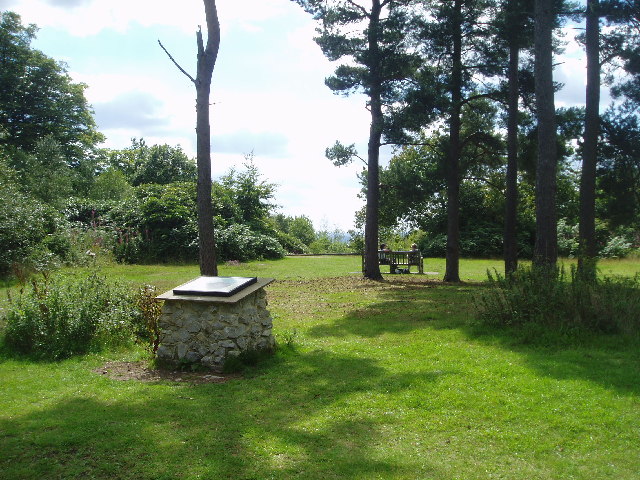
| Toys Hill | 3.7 miles (6 km) | Visit the highest point on the Kent Downs on this circular walk in Sevenoaks. There's hundreds of acres of woodland to explore with wonderful views over the Weald of Kent. This circular walk starts at the National Trust car park and follows footpaths to the Toys Hill viewpoint where you can stop and soak in the views over the Kent countryside. The route then heads along Scords Lane and Scords Wood where you pick up the Greensand Way to take you to the village of Ide Hill. On this section you will pass the memorial bench to Octavia Hill, founder of the National Trust. The area is one of the National Trust's first properties with the estate now occupying more than 200 acres. The pretty village of Ide Hill marks the half way point on the walk so it's a nice place to stop for refreshments. Ide hill has a nice village green and the 19th century St Mary's church, the highest church in Kent. After leaving Ide Hill you head to the beautiful Emmetts Garden. The 19th century garden contains many exotic trees and shrubs from around the world. From here you head back to the car park via Scord Wood. This route is designed for walking but you can also bring your bike to Toys Hill and pick up one of the bridleways through the woods. If you head along Scords Lane you can pick up a bridleway taking you through Scords Wood to Emmetts Garden. If you would like to continue your walking in the area then you could head along the Greensand Way to the nearby Chartwell House. Our 8 mile Westerham Circular Walk visits the hill and Chartwell from the town centre. View Full Details>> | |
| Weardale Walk | 5 miles (8 km) | This circular walk explores the National Trust area around Toys Hill and Octavia Hill in Kent. View Full Details>> | |
| Westerham | 7.9 miles (12.7 km) | Westerham is located in the Sevenoaks District of Kent, a great location for exploring the beautiful Kent Downs. This 8 mile circular walk makes use of the Greensand Way and other footpaths to visit Chartwell House and Toys Hill, two of the major highlights of the area. The walk starts from the town centre where you can pick the Greensand Way, waymarked footpath. Follow the trail south and it will soon take you past the noteworthy Squerryes Court. The late 17th-century manor house is surrounded by extensive gardens and parkland and is a grade I listed building. You continue south along woodland trails to Goodley Stock and Crookhammill Common where there are nice views toward Edenbridge. View Full Details>> | |
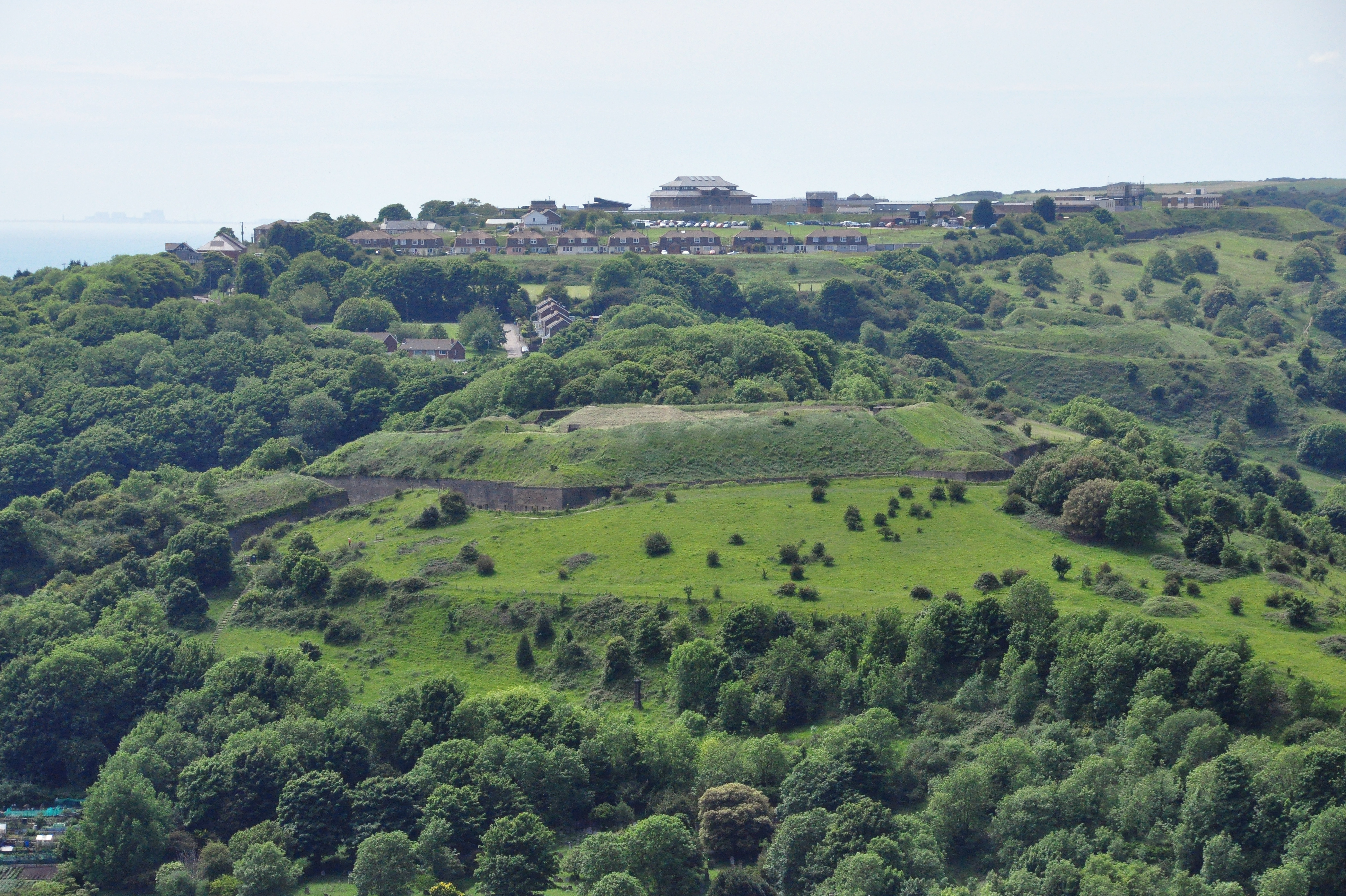
| Western Heights Dover | 2.8 miles (4.5 km) | This walk explores a fascinating series of forts, strong points and ditches located in Dover. The forts were created during the 18th and 19th centuries to protect the key port of Dover from both seaward and landward attack. There are good footpaths to follow around the elevated site which includes nice views towards Dover Castle and the North Downs. Start the walk from Drop Redoubt Fort at the eastern end of the complex. It's located just to the south of Piory rail station and just behind the pier and marina. The construction of the Redoubt was in two periods: the first being from 1804-1808 during the Napoleonic Wars, and the second from 1859-1864 following the recommendations of the 1859 Royal Commission. Follow the footpaths west and they will take you to the noteworthy Knights Templar Church. The ruins date from the 11th century and are located on Bredenstone hill. The route continues west to the second fort on the complex, known as 'The Citadel'. This structure was formerly a young offenders' institution, and was most recently used as the Dover Immigration Removal Centre. In the 19th century it contained barracks, stores and magazines arrayed around a large parade ground. At the Citadel Battery the route turns around and heads east along the southern part of the site. To continue your walking in the area head east and visit the historic Dover Castle and the famous White Cliffs on our Dover Cliffs Walk. The North Downs Way also runs through the site so you could pick this up easily too. View Full Details>> | |
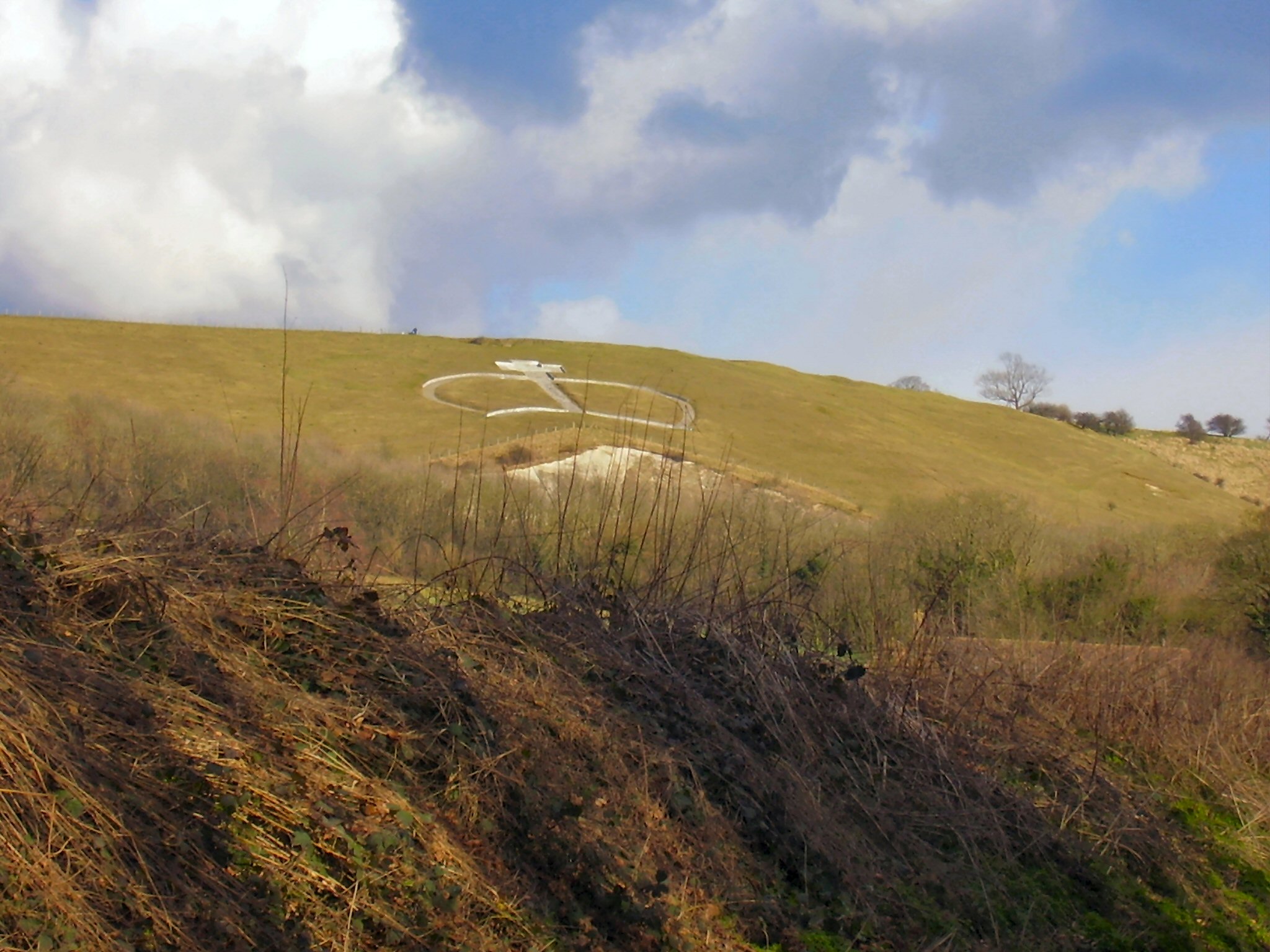
| Wye Crown | 4 miles (6.5 km) | Enjoy a short walk to Wye Crown in the beautiful Wye Downs. The hill figure is one of the landmarks of the area and a great spot to enjoy views over the Kent Downs AONB. The circular walk starts in the village of Wye just to the west of the Downs. You can pick up the North Downs Way and follow the waymarked trail east to the Wye Crown. View Full Details>> |