Cornwall Walks

Use the filter to show walks of a certain type such as woods, reservoirs, hills, long distance, country parks, canals and rivers.
In the spring walkers flock to the beautiful bluebell woods in the Cornwall area. Click the 'Woodland' button below to see these.
Use the links to view full route information including elevation profiles, interactive maps and GPS downloads.
You can also view an overview map of all the routes in the using the Cornwall Walk Map>>
*New* - Walks and Cycle Routes Near Me Map - Waymarked Routes and Mountain Bike Trails>>
| Filter: |
| Route Name | Photo | Distance | Description |
| Argal Reservoir | 2.1 miles (3.4 km) | This walk visits the lovely Argal Reservoir near Penryn and Falmouth in Cornwall. It's a lovely place for a walk with fine views across the water to the surrounding Cornish countryside. View Full Details>> | |
| Bedruthan Steps | 5.3 miles (8.5 km) | This walk takes you to a stunningly beautiful stretch of Cornish Coast where you will find the Bedruthan Steps. View Full Details>> | |
| Botallack Mine | 1.2 miles (2 km) | This circular walk visits the historic Botallack Mine from the west Cornish village of Botallack. View Full Details>> | |
| Brown Willy | 4.3 miles (7 km) | Climb to the highest point on Bodmin Moor on this circular walk in north east Cornwall. The summit stands at a height of 1,378 feet (420 m) making it the highest point in the county as well. There's fantastic views across the moor to the Cornish coast and a number of fascinating historical sites to see on the way. Start the walk from the car park at the end of Roughtor Road, just to the north west of the hills. You then follow paths south east onto the Roughtor Moors and up to Rough Tor. The fascinating site is the 2nd highest point on the moors and includes a logan stone, a neolithic tor enclosure, a large number of Bronze Age hut circles, and some contemporary monuments. After exploring Rough Tor the route branches to the left to visit Showery Tor. The granite Tor is a prominent landmark consists of a natural outcrop enveloped by a giant man-made ring cairn thought to have been a religious focal point. The route then continues the ascent to Brown Willy, crossing the De Lank River on the way. Here you can see a number of Bronze Age cairns including a summit cairn thought to be the resting place of an ancient Cornish king. After exploring the summit and taking in the views the route then descends across the Rough Tor Moors, passing more cairns before returning to the car park. View Full Details>> | |
| Bude Canal | 6.8 miles (11 km) | Enjoy an easy stroll along the Bude Canal on this fine circular walk in Cornwall. As well as taking in the canal you'll visit the coast Widemouth Bay and enjoy some fine views over Bude Bay from the coastal path. The walk starts from the information centre car park which is located next to the canal. From this end of the canal there are fine views of the beach and the sea. From the car park you can pick up the towpath and head south to Lynston Roddsbridge. The area around the canal is also part of the Bude Marshes Nature Reserve. Habitats in the reserve include reed bed, wet grassland, woodland and willow carr. You can look out for a variety of birds from the bird hide, while otters can also been seen around the canal and river. At Helebridge you leave the canal and follow a public footpath west through the countryside. The path leads to Widemouth Bay where there is a lovely beach. It's also a good opportunity to rest your legs and get some refreshments at the lovely beachside bar. The area around the bay is steeped in the smuggling history of times before, and not far south of Widemouth Bay can be found many little inlets and coves. At Widemouth you pick up the South West Coast Path and follow it north to Phillip's Point where there is a small nature reserve run by the Cornwall Wildlife Trust. You continue north to Upton and Efford Beacon where you'll find a trig point and fine views back down to Bude. View Full Details>> | |
| Camel Trail | 18 miles (29 km) | This wonderful riverside trail follows a disused railway line and the River Camel from Padstow to Poley's Bridge. View Full Details>> | |
| Cape Cornwall | 4.3 miles (7 km) | This stunning coastal walk visits the beautiful Cape Cornwall and the Botallack Mines near St Just. There is a National Trust car park right next to the headland from which this walk starts. You pick up the South West Coast Path and head around Cape Cornwall passing the lovely Priest's Cove and the remains of St Helen's Chapel. There are great views towards the Isles of Scilly and Land's End. You continue along the coast to Kenidjack headland where there is an Iron Age Cliff Castle, pretty wildlfowers and rare breed cattle. The next section follows footpaths along the coast and inland, exploring the fascinating ruins of the Botallack Mines. The mines were worked for tin and copper for over 500 years and include the Wheal Edward engine house and the Crowns engine houses. It's a great place for taking photos of the old ruined mining buildings with the backdrop of the coast and cliffs. You can also stop in the village of Botallack for refreshments before the return leg. The route then takes you through the countryside past Kenidjack Farm and Boscean, before picking up the coast path to return you to the car park. The long distance Zennor Churchway and Tinners Way passes the area so you could pick up this trail to further explore the area. The circular walk offers splendid views of the Cornish countryside and coast around St Ives and St Just. View Full Details>> | |
| Carbis Bay to St Ives | 2.2 miles (3.5 km) | This is an easy coastal walk from Carbis Bay to St Ives, with wonderful views over St Ives Bay. It's a good surfaced path, running along a section of the long distance South West Coast Path. You'll pass the golden sands of Carbis Bay beach, Porthminster beach and Porthmeor beach. The popular walk also visits St Ives Head before finishing on Porthminster beach, next to the Tate Gallery St Ives. The walk starts from Carbis Bay train station so you can get the train back from St Ives. You follow a path above the train line towards Porthminster Point and beach. The walk then descends to the town, heading along the beach to the pier and harbour. You then round St Ives Head before finishing at the Tate. The gallery has rotating modern art exhibitions, focusing on British artists. Nearby, the Barbara Hepworth Museum and Sculpture Garden, in the modernist artist's former studio, displays her bronzes and other works. Boat trips go to the nearby seal colonies on the Carrack Rocks and other locations along the coast. The beaches are beautiful and there's numerous places to buy refreshments before the return leg of the walk. To extend the walk you can continue along the coast path on the St Ives to Zennor Walk. Heading east will take you to the lovely Hayle Estuary where there is a RSPB reserve and tremendous views of Porth Kidney Sands. The long distance St Michaels Way also passes through the area. Pick this up to visit the famous St Michael's Mount. View Full Details>> | |
| Cardinham Woods | 4.3 miles (7 km) | This large mixed woodland forest near Bodmin is very popular with walkers and cyclists. View Full Details>> | |
| Colliford Lake | 3.7 miles (6 km) | Enjoy a lovely waterside walk along the shore of this large lake on Bodmin Moor. At over 900 acres it is the largest lake in Cornwall. View Full Details>> | |
| Copper Trail | 60.3 miles (97 km) | Visit some of the most beautiful parts of Bodmin moor on this circular route which takes you on a tour of the historic Cornish Copper mines. The Trail begins at Minions village and visits St. Neot, Bodmin, St. Breward, Camelford, Five Lanes and back to Minions. The first section takes you from Minions and heads towards the delightful village of St Neot, passing the River Fowey and the photogenic Golitha Falls. You continue from St Neot to Bodmin with lovely waterside sections along the River St Neot and past Colliford Lake. Just outside Bodmin there is a peaceful wooded section through Devlock Wood. At Bodmin you join the delightful Camel Trail, following the River Camel to St Breward and onto Camelford. From Camelford you head through Davidstow Moor, passing Crowdy Reservoir, Davidstow Woods and the old WW2 Control Tower. View Full Details>> | |
| Cotehele House | 2.5 miles (4 km) | This walk explores the beautiful grounds of a Tudor house near Saltash, before heading to the nearby village of Calstock. View Full Details>> | |
| Crowdy Reservoir | 2.5 miles (4 km) | This short walk follows a section of the Copper Trail from Crowdy Reservoir to Davidstow Woods on Bodmin Moor. The walk starts from the Crowdy Reservoir car park and follows country lanes past the reservoir to the nearby woods. It's a nice easy short walk with good views across the water to the surrounding countryside. The reservoir and the surrounding Crowdy marsh are also good for birdwatching with gadwall, goldeneye, goosander, mallard, common pochard, shoveler, teal and tufted duck to look out for. You may also see ponies grazing on Davidstow Moor. View Full Details>> | |
| Dodman Point | 2.2 miles (3.5 km) | This circular walk explores a wonderful headland on the Cornish coast. The area is located near the village of Gorran Haven and is the highest headland on the south coast of Cornwall. There's splendid coastal views, pretty beaches, lovely countryside and lots of wildlife to look out for. The walk starts from the Penare car park, about half a mile south of Dodman Point. From here you head west towards Hemmick Beach with wonderful views across Veryan Bay to the west. You then pick up the South West Coast Path to take you up to Dodman Point. Here you will find a large granite cross, placed here in 1896 as a navigational aid to seafarers. From the elevated headland there are fabulous views towards the Roseland Peninsula. Look out for wildlife including Dartmoor ponies, peregrine falcon, stonechat and gannet. The walk can also be started from the nearby village of Gorran Haven if you prefer. It's about a 2 mile walk from the village along the coast path to the point. It will take you past the lovely Vault Beach and the delightful Gorran Harbour. View Full Details>> | |
| Falmouth | 5 miles (8 km) | A coastal walk around the Cornish town of Falmouth visiting Pendennis Point, Pendennis Castle and the pretty Swanpool lake nature reserve. Starting at the pier the walk follows the South West Coast Path past the quays and docks to Pendennis Castle. The artillery fort was constructed by Henry VIII between 1540 and 1542. It is run by English Heritage so you can explore the battlements, war rooms, barracks and cells with exhibitions detailing the history of the castle. It's in a fantastic position, commanding fine views across Falmouth Bay to the Roseland Peninsula. After leaving the castle the footpath rounds Pendennis Point and heads west to Swanpool, passing two nice beaches on the way. The small saline lagoon is great for wildlife watching with Little grebe, Tufted Duck and Moorhen to look out for. It's a really lovely spot with the lake separated from the sea by the pretty Swanpool beach. The site also includes and outdoor cafe, crazy golf course, water-sports and kayak hire. View Full Details>> | |
| Fowey Hall Walk | 3.7 miles (6 km) | This popular circular walk in Fowey involves two ferry crossings and lovely waterside sections along Pont Pill and Fowey Quay. Along the way you'll enjoy wonderful views over Fowey Harbour, the River Fowey and the south coast. There's also pretty little quays, Cornish villages and splendid pubs for refreshments. The walk starts in Fowey, at the Fowey to Bodinnick Ferry. After catching the ferry to Bodinnick you pick up the footpath and head south to the 'Q' memorial. The route then runs east along the green waters of the tidal river of Pont Pill to the pretty hamlet of Pont. Here you cross a footbridge to the southern side of Pont Pill and head west to Polruan. At Polruan you catch the ferry back to Fowey and finish the walk with a stroll along the quay. View Full Details>> | |
| Fowey to Polkerris Walk | 6.2 miles (10 km) | This lovely route from Fowey makes use of the South West Coast Path and the Saints Way to create a splendid circular walk to the village of Polkerris. It's a varied walk with river views, beautiful coast and some gorgeous Cornish countryside on the inland stretch. The route runs for just over 6 miles on good waymarked footpaths with a few moderate climbs along the way. The walk starts at the quay in Fowey and heads south west along the mouth of the River Fowey, passing Readymoney Cove. The delightful little cove is sheltered by cliffs close to the river estuary and bounded, on one side, by the medieval part of the town and, on the other, by the 16th century St Catherine's Castle. The path then heads to Southground Cliffs, Lankelly Cliffs and Gribbin Head. The National Trust owned promintory is one of the highlights of the area. It separates St Austell Bay from the estuary of the River Fowey and is marked by the Gribbin Tower which is used to aid navigation of ships approaching the local harbours. A herb rich grassland including early purple orchid and grazing cows can be seen on the headland. The route then turns north towards Polkerris. The village has a nice sandy beach, a curved harbour wall, restaurants, water sports and some accommodation. It's a good place to stop for refreshments before completing the final section of the walk. At Polkerris you pick up the Saint's Way and head east through some attractive countryside to return to Fowey. View Full Details>> | |
| Glendurgan Garden | 0.9 miles (1.5 km) | These lovely National Trust owned gardens are located near Falmouth in Cornwall. View Full Details>> | |
| Godolphin Estate | 1.6 miles (2.5 km) | Enjoy a short walk around the estate surrounding this Grade 1 listed Tudor/Stuart mansion near Helston in Cornwall. View Full Details>> | |
| Godrevy Head | 5.3 miles (8.5 km) | Explore Godrevy Head and enjoy wonderful views of St Ives Bay and the Cornish coast on this splendid coastal walk. The area is managed by the National Trust so there's good footpaths and facilities along this stretch of coast. Along the way there's pretty beaches, attractive countryside, heathland and a wide variety of wildlife to look out for. Keep your eyes peeled for dolphins, seals and basking sharks in the water below. You can start the walk from the Godrevy National Trust car park off Churchtown Road, near Gwithian Bridge. You then head north along the coast path towards Godrevy Point where there are splendid views towards Godrevy Island and its lighthouse. The path continues along the headland to Navrax Point, passing Kynance Cove on the way. The route then turns south passing the lovely heathland of The Knavocks where you should look out for ponies grazing. The final section passes Castle Giver Cove and Higher Pencobben before finishing at Hell's Mouth where you can watch hundreds of seabirds around the cliffs. View Full Details>> | |
| Golitha Falls | 0.6 miles (1 km) | Golitha Falls National Nature Reserve has woodland walking trails taking you through a steep-sided valley gorge. The River Fowey runs through the gorge with a series of spectacular cascades known as Golitha Falls. The reserve is excellent for interesting flora and fauna with diverse plantlife including bluebells, wildflowers, cow-wheat, bilberry and wavy-hair grass. Look out for wildlife including butterflies, bats and birds such as dipper, nuthatch, treecreeper and buzzard. There is a good size car park at Draynes Bridge from which this walk begins. Golitha Falls is located just a few miles north of Liskeard. If you would like to extend your walking in the area then you could head to the nearby Siblyback Lake where you will find a lovely waterside footpath. View Full Details>> | |
| Goonhilly Downs | 4.7 miles (7.5 km) | This walk explores a large area of heathland situated in the Lizard National Nature Reserve in Cornwall. The site is located next to the Goonhilly Satellite Earth Station, with its iconic satellite dishes which can be seen for miles. The remains of RAF Drytree, a radar station built during WWII are also visible in the reserve. You can explore some interesting buildings including an air raid shelter and receiver block which you can climb to the top of for panoramic views on the surrounding countryside On the downs you will find areas of woodland, a large pond and interesting plants such as the Heath Spotted Orchid. Also look out for wildlife including ponies and deer as you make your way around the reserve. View Full Details>> | |
| Goss Moor Trail | 7.5 miles (12 km) | This super Cornish trail is suitable for both walkers and cyclists and takes you on a tour of the 480 hectare Goss Moor National Nature Reserve. View Full Details>> | |
| Great Flat Lode Trail | 6.5 miles (10.5 km) | This is a short, circular off road walk or cycle that circles the historic hilltop site of Carn Brea. The route is one of Cornwall's Mineral Tramway Trails which take you on a tour of the disused mines of the county. You will pass South Wheal Frances and South Crofty mines as you head through some beautiful Cornish countryside. Good access points are Camborne or Redruth train stations, or the car park at Treskillard. The route runs for about 7 miles on an undulating path with some climbs on the way. If you enjoy this trail you may also be interested in the Mineral Tramways trail which runs from Portreath to Devoran and also visits several historic mine buildings. View Full Details>> | |
| Grogley Woods | 2.7 miles (4.3 km) | These woods south of Wadebridge are a popular place for mountain bikes with several black MTB trails to try. View Full Details>> | |
| Gurnards Head | 2.9 miles (4.6 km) | This circular walk visits a stunning headland on the Penwith coast in Cornwall. View Full Details>> | |
| Hayle Estuary | 1.9 miles (3 km) | Enjoy a walk or cycle around the beautiful Hayle Estuary RSPB reserve in Cornwall. A section of the South West Coast Path runs along the estuary from Hayle Harbour to Lelant. There's tremendous views of Porth Kidney Sands and a visit to Griggs Quay to enjoy. The route starts in Hayle near to the train station and harbour. You soon come to the delightful Carnsew Pool where there is a circular walking trail around the water. You continue towards Lelant Water and RSPB Ryan's Field. Here you will find a lagoon with little islands where you can look out for a variety of birds. The next section takes you past Griggs Quay to Lelant where you have the option of continuing to Porth Kidney Sands. The reserve is wonderful for bird watching with 18,000 birds including many wading birds, gulls and terns. Look out for teal, curlew, little egret and oystercatcher as you make your way around this stunning area. In Hayle you can also visit the Copperhouse Pool next to the harbour. There's a path along the Copperhouse Creek where you can get very close to the birds. View Full Details>> | |
| Hayle to St Ives | 5.3 miles (8.5 km) | This walk explores the Hayle Estuary and Carbis Bay on the South West Coast path in Cornwall. It's a stunning area with lots of wildlife to look out for on the estuary and wonderful beaches with views of St Ives Bay as you approach St Ives. It's a fairly easy 5 mile walk with only a few fairly easy climbs along the way. Starting at the train station in Hayle, pick up the coast path to take you past the pretty quays and harbour. The path bends around the estuary to Lelant Saltings and then through Lelant, before coming to Porth Kidney Sands. You pass along the beautiful beach to the golden sands of Carbis Bay. The route then comes into St Ives, passing Porthminster Beach on the way. In St Ives you can visit the Tate gallery and the Barbara Hepworth Museum which includes a fine Sculpture Garden. You can also catch boat trips to the nearby seal colonies on the Carrack Rocks and other locations along the coast. View Full Details>> | |
| Helford River Walk | 5.2 miles (8.4 km) | This circular walk follows a section of the South West Coast Path along the lovely Helford River in Cornwall. The popular estuary includes pretty creeks, old churches, nice beaches and lovely coastal views over Falmouth Bay. View Full Details>> | |
| Helman Tor | 2.2 miles (3.5 km) | This circular walk climbs to Helman Tor and then visits the adjacent Breney Common Nature Reserve in Bodmin. You can park at the Helman Tor car park just south of the hill to start your walk. It's a short climb from here to the rocky outcrop which stands at a height of 209 m (686 ft). From here there are fabulous views over the surrounding Cornish coutntryside. After descending from the tor the route then follows the Saints Way long distance trail around Breney Common. The reserve covers over 500 acres with heathland, grassland, wetland, woodland and ponds. It's great for widlife with grazing ponies and the rare Orange Tip butterfly to look out for. Various wildfowl can be seen on the open water too. View Full Details>> | |
| Idless Woods | 2.5 miles (4 km) | Enjoy miles of woodland walking and cycling trails in this beautiful area of mixed woodland near Truro. This circular route starts at the car park at the western end of the forest and takes you around the area on good paths. Features in the forest include an Iron Age hill fort, lots of pretty bluebells in spring and the River Allen which runs past the western end of the forest. The woods are made up of beeches, larches and eucalyptus. It's a great for wildlife too with roe deer, otters and badgers to look out for. The woods are are very popular with mountain bikers with numerous off road trails to try. View Full Details>> | |
| Kennall Vale | 1.2 miles (2 km) | This nature reserve near Falmouth has a series of walking trails to follow. The reserve consists of woodland with pretty streams and interesting flora and fauna to look out for. Keep your eyes peeled for the pipistrelle bat and a variety of woodland birds. It's a lovely shady spot with the rushing waters of the River Kennall and the sound of the birds in the trees. The area also has an interesting history with the ruins, leats and waterwheel houses of Kennall Vale Gunpowder Works. You can start the walk from the little village of Ponsanooth which lies just to the east of the reserve. To extend your walking in the area then you could visit the nearby Stithians Lake. The country park includes nice cycling and walking trails around a large lake. View Full Details>> | |
| Kit Hill | 1.2 miles (2 km) | This country park in Cornwall covers 400 acres with miles of good footpaths to try.
The park was given to the people of Cornwall in 1985 by Prince Charles to mark the birth of his son Prince William.
You can climb to the 334 m (1,096 ft) Kit Hill summit and enjoy wonderful views over the Tamar Valley AONB, Dartmoor and Bodmin Moor. At the top of the hill you'll find an artificial fort and a folly built built in the style of a low-walled Saxon castle. There's also a number of viewing tables which highlight features of the surrounding countryside you can see from the summit. The area is great for wildlife with buzzards, sparrowhawks, deer and various butterflies to look out for. Attractive vegetation includes heathers, gorses, grasses and bilberry. There's also an interesting mining history with the 19th century Summit Stack a well known landmark. The park is located just to the north of Callington and has a car park on the eastern side near Monkscross. To continue your walking in the area you could try the Tamar Valley Discovery Trail and enjoy a waterside walk along the River Tamar. If you head a couple of miles east to Chilsworthy you can pick up the trail there. Also nearby is the splendid Cotehele House. The Tudor house has nice footpaths taking you around the extensive grounds. View Full Details>> | |
| Land's End Trail | 303.2 miles (488 km) | This terrific trail runs for over 300 miles from Land's End in Cornwall to Avebury in Wiltshire, passing through Devon and Somerset on the way. The walk has been spit into a number of manageable stages as follows 1 Land's End 2 Bosullow Common 3 St. Erth 4 Leedstown 5 Beacon, Camborne 6 Chiverton Cross 7 Mitchell 8 Tregonetha 9 Dunmere Bridge 10 St. Breward 11 Jamaica Inn, Bolventor 12 Minions 13 Callington 14 Tavistock 15 Lydford 16 Belstone 17 Sampford Courtenay 18 Chulmleigh 19 South Molton 20 Dulverton 21 Wiveliscombe 22 Bishop's Lydeard 23 Bridgwater 24 Glastonbury Tor 25 Bruton 26 Warminster View Full Details>> | |
| Lanhydrock | 2.5 miles (4 km) | This walk takes you to the beautiful Lanhydrock estate from Bodmin Parkway Train Station. You can catch a train from Truro or St Austell to Bodmin Parkway and then follow footpaths to Lanhydrock. It's a nice two mile walk along the River Fowey and through woodland to the National Trust owned Victorian country house. The estate is very special with wonderful architecture and beautiful gardens. There are 1000 acres of woodland, parkland and gardens to explore on a network of good footpaths. Highlights include the magnolia arch by the thatched cottage and beautiful herbaceous borders. You can also visit the magnificent house and explore the kitchen area, servants' quarters and museum. Although the whole of this route is designed for walkers cyclists can also enjoy a number of trails in the estate. There are easy, moderate and difficult trails to try. Click here to see a trail map or look at the Open Street Map link below which shows the trails marked in blue just to the north of the car park. You can also hire bikes within the estate. To continue your walking in the area head a couple of miles south and you can pick up the Saints Way long distance trail. You can then visit Helman Tor and the Breney Common Nature Reserve where you can enjoy fine views over Bodmin Moor and look out for wildlife including Ponies and the rare Orange Top butterfly. In nearby Bodmin you can pick up the Camel Trail cycling and walking route which will take you along the River Camel on a splendid traffic free path. The Cornish Way cycle route also passes close to the estate. View Full Details>> | |
| Launceston | 5.3 miles (8.5 km) | This Cornish town sits on the border with Devon in the lovely Tamar Valley. Two excellent waymarked trails begin their journey in Launceston, in the shape of the Two Castles Trail and the Tamar Valley Discovery Trail. These are both great options for exploring the beautiful countryside surrounding the town. This walk uses a section of the Two Castles Trail to take you to the nearby village of Lifton. You start of at Launceston Castle which has a history dating back to the 11th century. Today the castle is owned by the duchy of Cornwall and operated by English Heritage as a tourist attraction. Much of the castle defences remain, including the motte, keep and high tower which overlook the castle's former deer park to the south. The castle marks the start of the Two Castle's Trail which you can follow east through the countryside to Liftondown and and Lifton in Devon. The pretty village sits on the confluence of the rivers Wolf and Lyd so there are some nice riverside paths to try in this area. You can return to Launceston on the same paths or catch the bus back if you prefer. View Full Details>> | |
| Lizard Point to Kynance Cove | 8.7 miles (14 km) | This circular walk takes you from Lizard Point to Kynance Cove and then visits the Lizard National Nature Reserve and the little village of Cadgwith on the Cornish Coast. There's some truly spectacular coastal scenery with stunning coves, beautiful beaches, turquoise seas and imposing cliffs. You start off at the Lizard Point car park and head around Lizard Point, the most southerly place in Britain. It's a beautiful and unique area with interesting geological formations and a variety of flora and fauna. The walk continues north to Kynance Cove via Crane Ledges and Pentreath Beach. Kynance Cove has spectacular cliffs, stacks, arches and islands of serpentine rock while the beach is considered one the most beautiful in the world. The area is also covered with attractive heathland and a variety of rare coastal plants. From Kynance Cove you head inland across the Lizard National Nature Reserve and Lizard Downs to Cadgwith. The tiny fishing village is very picturesque with thatched cottages and a pretty stream trickling over the sand and shingle beach. At Cadgwith you pick up the coast path again to take you back to the car park. On this final section you pass interesting geological features such as Whale Rock and the Devil's Frying Pan. The latter was formed from the collapsed roof of a sea cave with a remaining arch of rock. The walk is also great for wildlife spotting. Look out for grey seals in the water and the Cornish Chough in the air. The walk can be extended by continuing along the South West Coast Path to Mullion Cove, north of Kynance Cove. View Full Details>> | |
| Loe Bar | 6.8 miles (11 km) | This circular walk explores the beautiful Loe Bar and Loe Pool, near Helston, in Cornwall. The pool is notable as largest natural freshwater lake in Cornwall. View Full Details>> | |
| Looe Island | 0.6 miles (1 km) | This delightful island of the Cornish coast is well worth a visit. You can catch a boat from East Looe during the summer months and then enjoy a 1km walk around the beautiful little island. It's a fantastic place for wildlife lovers with grey seals, cormorants, shags and oystercatchers to look out for. There's also wildflower meadows which attract different types of butterfly. Keep your eyes peeled for speckled wood, meadow brown and red admiral as you make your way across the meadows. The island also includes mix of grassland, scrub, woods and fabulous views back along the Cornish coast. The South West Coast Path runs through Looe so you could try the Looe to Polperro coastal walk to extend your walking in the area. View Full Details>> | |
| Looe to Polperro | 5.3 miles (8.5 km) | This is a popular walk between these two Cornish coastal villages. It follows the South West Coast Path for just over 5 miles with stunning views all the way. The walk starts in East Looe near the tourist information centre. The town has a lovely beach, pier, pretty harbour and picturesque Cornish cottages. After passing through East Looe you cross the bridge over the Looe Estuary into West Looe and follow the coast round to Hannafore (you can see some of this section on the google street view link below). There's great views of Looe Bay and towards the idyllic Looe Island on this section of the walk. From Hannafore you continue to Talland, passing Samphire Beach and Portnadler Bay. At Talland Bay you will find two nice shingle beaches called Talland Sand and Rotterdam Beach. There is also a church dating from the 15th century and a cafe where you stop for refreshments. The final section takes you from Talland to Polperro, passing the memorial at Downend Point and Chapel Cliff. The town has a lovely harbour and rows of ancient fishermen's cottages to admire. View Full Details>> | |
| Looe to Talland Bay Walk | 6.8 miles (11 km) | A circular walk from Looe visiting Talland Bay before returning to the town through inland country lanes. It's a varied walk with riverside paths, woodland trails, coastal sections and some hill climbs. The route is just under 7 miles with moderate climbs through the countryside after a fairly easy coastal section. The walk starts from West Looe, close to the train station. You head south along the Looe River to the coast at Hannafore before passing along Portnadler Bay. Here you can enjoy lovely views over to Looe Island. The island is a great place for wildlife lovers with grey seals, cormorants, shags and oystercatchers to look out for. The walk continues to Talland where you will pass the noteworthy St Tallanus' Church. The Grade I listed church dates from the 13th century and is positioned in a dramatic cliff top location. Shortly after you come to Talland Bay where you'll find two sheltered shingle beaches, Talland Sand and Rotterdam Beach. It's a lovely, unspoiled place and is both a designated Area of Outstanding Beauty and a Heritage Coast. After enjoying the bay the route then turns inland to follow footpaths and quiet lanes through the countryside to Tencreek, Parkers Cross and Kilminorth. Here you pass through the Kilminorth Woods nature reserve before picking up a riverside path to take you back into West Looe. View Full Details>> | |
| Lost Gardens of Heligan | 1.2 miles (2 km) | Enjoy a stroll around these stunning botanical gardens near Pentewan and Mevagissey in Cornwall. There are 200 acres to explore with Victorian Productive Gardens, romantic Pleasure Grounds and a lush sub-tropical Jungle. Highlights include the super woodland walk where you will pass some of the amazing Heligan sculptures including The Giant's Head, Mud Maid and Grey Lady. In the jungle section you can cross the long Burmese Rope Bridge over the tranquil ponds then lose yourself in tunnels of towering bamboo. In the pleasure grounds you'll find Maori-carved tree ferns, ancient rhododendron boughs and the delightful Mediterranean Italian Garden. You can also venture into the wider estate where there are wonderful views of the surrounding Cornish countryside. Also look out for a variety of wildlife including insects and butterflies in the wildflower meadow. You can 'virtually' explore the gardens using the google street view link below. There is parking available at the gardens but if you wanted to walk or cycle to Heligan you could follow the Pentewan Trail from either St Austell or Mevagissey. It's a super off road cycle and walking trail which runs along National Cycle Route 3 and passes the eastern side of the gardens. You can extend your walking from Mevagissey by following the coast path south to the village of Gorran Haven. Here you will find a lovely harbour, beautiful beaches and the highest headland on the south coast of Cornwall at Dodman Point. View Full Details>> | |
| Mary Michael Pilgrims Way | 275.3 miles (443 km) | This route begins on the Cornish coast, near Land's end, and passes through Cornwall, Devon and Gloucestershire to finish at Glastonbury. However, the vision is to extend the route to the Norfolk coast in the near future. View Full Details>> | |
| Mawgan Porth to Bedruthan Steps Walk | 3.4 miles (5.5 km) | A coastal walk from the beach at Mawgan Porth to the Bedruthan Steps in Cornwall. It's just under 2 miles from the beach to the steps so just under 4 miles there and back. View Full Details>> | |
| Mineral Tramways Trail | 14.3 miles (23 km) | Also known as the Bissoe Trail, this is a fabulous, largely traffic free ride or walk, from Portreath to Devoran. The Mineral Tramways Coast to Coast trail takes you on a tour of some of Cornwall's historic mine buildings. The trail runs for about 14 miles along a path which steadily climbs to Wheal Busy before descending to Devoran. The path starts on the coast at Portreath and heads through Wheal Rose, Todpool and Bissoe to Devoran. As well as the series of restored mines you will pass the beautiful Bissoe Valley Nature Reserve. The reserve was a former mine site and has heathland, woodland, ponds and variety of widlife. View Full Details>> | |
| Mount Edgcumbe Country Park | 3.4 miles (5.5 km) | With 865 acres of parkland, beautiful landscaped Cornish gardens and stunning coastline, Mount Edgcumbe Country Park is a fantastic place to visit. This circular walk begins at the parking lot, near the Cremyll Ferry which you can catch from Plymouth to the park. The path then joins the coastal path to Raveness Point, passing the beautiful Barn Pool (see video) and the Raven's Cliffs. You continue to Picklecombe Point before returning to the start point through the delightful deer park, passing the magnificent Mount Edgcumbe House on the way. View Full Details>> | |
| Newquay to Crantock | 9 miles (14.5 km) | This circular walk takes you from Newquay to Crantock via Towan Head and Pentire Point. The walk starts from the town centre next to the train station and bus station. From here you can pick up the South West Coast Path and follow the waymarked trail up to Towan Head. You then head south along the popular surfing area at Fistral Beach before coming to Pentire. Follow the footpath around the headland at Pentire Point where there are nice views down to the lovely Crantock Beach. View Full Details>> | |
| Newquay to Perranporth | 11.2 miles (18 km) | This is a popular coastal walk between Newquay and Perranporth along a section of the South West Coast Path. The walk is about 11 miles so it's perfect for a day's outing. It's a fantastic stretch of coast with lovely beaches, exhilirating cliff tops and beautiful bays. At Perranporth you can enjoy refreshments before catching the bus back to Newquay. The walk starts off in the centre of the popular tourist town of Newquay, near to the train station and the bus station. You then follow the coast path through the town towards Towan Head where there are lovely views over the Newquay beaches. The path then heads along the popular surfing spot of Fistral Beach. You then cross the River Gannel to Crantock Sands which may require the use of the ferry at high tide. The route then visits Pentire Point and Kelsey Head before descending to the beautiful Holywell Beach which has a wonderful dune system and is managed by the National Trust. The route then rounds Penhale Point before crossing Penhale Sands which has the most extensive system of sand dunes in Cornwall. After crossing the sands you arrive at the pretty little town of Perranporth where you can enjoy a well earned drink at the UK's only bar on the beach. To extend your walk you can continue along the coast path to St Agnes Head and enjoy a climb to St Agnes Beacon and a visit to the fascinating ruins of the Wheal Coates tin mine. See the Perranporth to St Agnes Walk for details of the route to the headland. Beyond there is the pretty village of Porthtowan. A few miles north of Newquay you can visit the Bedruthan Steps, a series of large photogenic rocks along the beach. View Full Details>> | |
| Penrose Estate | 6.5 miles (10.5 km) | This lovely National Trust owned estate near Porthleven has a number of excellent cycling and walking trails around a large coastal lake. The Loe or Loe Pool is the largest natural freshwater lake in Cornwall. View Full Details>> | |
| Pentewan Trail | 6.8 miles (11 km) | The Pentewan trail is a lovely traffic free cycle and walking path running from St Austell to Mevagissey. View Full Details>> | |
| Penwith Moors and Men-An-Tol | 5.6 miles (9 km) | This walk explores a fascinating area of the Penwith Moors SSSI in Cornwall. View Full Details>> | |
| Penzance to Mousehole | 3.4 miles (5.5 km) | This walk follows a section of the South West Coast Path from Penzance to Mousehole via Newlyn. View Full Details>> | |
| Penzance to St Ives | 8.7 miles (14 km) | This popular walk takes you between two major towns on the beautiful Cornish coast. View Full Details>> | |
| Poldice Valley | 3.7 miles (6 km) | The Poldice Valley is located in southwest Cornwall near Redruth. View Full Details>> | |
| Polperro to Polruan Walk | 6.8 miles (11 km) | This route follows a wonderful section of the South West Coast Path from Polperro to Polruan in Cornwall. The walk runs for just under 7 miles on an undulating cliff top footpath, with fabulous views from the high points. The area between the two villages is designated as a coastal Site of Special Scientific Interest (SSSI) and a Special Area of Conservation. Habitats include shingle beaches, maritime grassland, scrubland, farmland and cliff tops. It's great for wildlife too with notable bird species including Dartford warbler and peregrine falcon. The walk starts at the delightful harbour in Polperro and heads to the coast at Chapel Cliff. You then continue west towards Lansallos where you will find a lovely cove and beach with a waterfall. This area is managed by the National Trust and includes pretty wildflowers and many birds to look out for on the cliffs and farmland. The route continues through West Combe to Pencarrow Head where you will pass the Great Lantic and Little Lantic beaches. The final section runs past Blackbottle Rock before finishing at the quay in Polruan. The small fishing village is bounded on three sides by water: to the north by Pont Creek, to the west by the River Fowey and to the south by the English Channel. Highlights in the village include the fine views of the Fowey Estuary, the little boats in Polruan Pool and the St Saviour's Ruin which dates from the 8th century. View Full Details>> | |
| Port Isaac | 4.2 miles (6.7 km) | This picturesque Cornish village will be familiar to viewers of ITV's 'Doc Martin' show with Martin Clunes. The little fishing village includes a delightful harbour surrounded by cliffs and countryside made famous in the TV show. There's also a number of winding narrow streets with interesting 18th century cottages to see. View Full Details>> | |
| Porth Reservoir | 3.1 miles (5 km) | Enjoy a circular walk around this pretty reservoir near Newquay. You'll find a nature trail, bird hides and a visitor centre with information on the area. There's also an impressive dam, boardwalks, and woodland to enjoy. This walk starts at the parking area and takes you around the reservoir on footpaths and country lanes. If you're coming by bike you can reach the reservoir by riding east on National Cycle Route 32 from Newquay. For nice views down to the reservoir you can try the Colan Woods Walk which takes you along the country lanes and footpaths above the reservoir. View Full Details>> | |
| Porthcurno to Lands End | 5 miles (8 km) | Follow the South West Coast Path from the village of Porthcurno to Land's End, the most westerly point of England. It's a splendid section of the coast with fabulous cliff top views and lots of beautiful beaches along the way. The walk starts in the parking area in Porthcurno and heads to the beach and the wonderful Minack Theatre. The wonderful open air theatre is positioned above a gully with a rocky granite outcrop jutting into the sea. The path heads west to Rospletha Cliff and Porth Chapel beach at St Levan before coming to the coastal village of Porthgwarra. Here you can walk through a tunnel to visit a delightful little cove. The next section takes you around Hella Point to Gwennap Head. The headland is a great place for seeing unusual wildlife such as basking sharks and ocean sunfish. It's also favoured by birdwatchers with many travelling the length and breadth of Britain to track rare seabirds. Look out for gannet, Manx shearwater, guillemot, razorbill, fulmar, shag and cormorant as you make your way around the headland. View Full Details>> | |
| Porthtowan | 3.1 miles (5 km) | This circular walk explores the coast and countryside surrounding the lovely village of Porthtowan. It's a popular place with a beautiful beach, exhilirating cliff top paths and a series of mine stacks and engine houses dotting the landscape. This 3 mile circular walk starts at the coastal car park and takes you along the South West Coast Path towards Chapel Porth which has a nice little beach. The path then heads through the Chapel Combe valley with views to the passing Great Wheal Charlotte Mine. At Towan Cross you pick up another path taking you through the countryside to the car park. You can extend the walk by following country lanes to Mount Hawke where there is a nice path along a stream. To continue your walking in the area you could follow the South West Coast Path north to St Agnes Head. There's some lovely coastal heathland in this area and the fascinating Wheal Coates former tin mine. You can visit these locations on our St Agnes Head - St Agnes Beacon - Wheal Coates Walk. View Full Details>> | |
| Prideaux Place | 1.2 miles (2 km) | Enjoy a peaceful walk around the delightful grounds and deer park surrounding this 16th century house in Padstow, on the Cornish coast. In the grounds you will find an 80 tree lime avenue, a Victorian Formal Garden and pretty woodland paths. In the deer park you can see one of the oldest park herds in the country. From the tea room you can watch them being fed with views across the Camel Estuary. Prideaux Place is an Elizabethan manor house still lived in by the Prideaux family. You can tour the house and see exquisite Italian paintings, family portraits, photographs, porcelain and antiques. The house is located just a few hundred metres from the Camel Estuary at Padstow, so you could continue your walk along the Camel Trail or the Saints Way which both run past the park. Heading north from Padstow will take you to the lovely Stepper Point and Daymark Tower. This coastal headland has great views of Padstow Bay and lots of interesting rock formations. You can follow the coastal path round to Trevone Bay where there is a nice beach and cafe. View Full Details>> | |
| Rame Head | 5.6 miles (9 km) | This circular walk explores the beautiful Rame Peninsula on the Cornish Coast. It's a fantastic place for a walk with wonderful views across Cawsand Bay to Plymouth Sound and the city of Plymouth. There's some nice coastal woodland and a visit to the mediaevel Rame Chapel. It's a great place for wildlife spotting with lots of sea birds and Dartmoor Ponies to look out for. The entire area of the peninsula is designated an Area of Outstanding Natural Beauty. The walk starts from the car park at Kingsand and follows the South West Coast Path to Penlee Point, before heading to Rame Head and the mediaevel chapel. You then head north along the coast before crossing the peninsula to return to Kingsand. View Full Details>> | |
| Redruth | 8.7 miles (14 km) | This Cornish town has some nice walking trails exploring the settlement's rich mining history. There's also some local hill climbs where you can enjoy views towards the nearby coast. View Full Details>> | |
| Roseland Peninsula | 9.9 miles (16 km) | Explore the beautiful Roseland Peninsula on this 10 mile walk on the Cornish coast. The walk starts from the village of Porscatho where there is a good sized car park by the coast. You could also start from nearby Gerrans where there is an interesting 13th century church. From the Porscatho car park you head south along the South West Coast Path, passing a series of pretty coves and beaches including the Carricknath Point and Porthbean Beach SSSI. Here you will find sand covered beaches, natural rock platforms with fragments of saltmarsh, cliff top grassland, low rocky headlands and a variety of rare plants. You continue south to Zone Point, at the southernmost extremity of the peninsula extending into Falmouth Bay. Near here you will find the National Trust owned St Anthony Head Lighthouse. The headland is one of the highlights of the peninsula overlooking the entrance to one of the world's largest natural harbours, Carrick Roads and the estuary of River Fal. The site also includes an old military fort with big guns, batteries and fortifications. Look out for wildlife including cormorants, shags and seals in this area. The route continues past the pretty Little Molunan beach before turning north along St Mawes Harbour with nice views across to St Mawes Quay. This section includes some nice woodland trails with bluebells, primroses and celandines to see. Also look out for a wide variety of butterflies fluttering around the wildflowers. The path then takes you along the Porth Creek with views down to the Percuil River and a stretch through farmland. The final section takes you back along the coast to Porscatho. To continue your walking in the area you could head to the nearby town of Falmouth and visit the fascinating Pendennis Castle and the lovely Swanpool Nature Reserve. You can also enjoy a walk from St Mawes to St Just with a visit to the fascinating St Mawes Castle and the St Just in Roseland 13th-century church with beautiful riverside gardens. The ferry from St Mawes will take you across the Fal Estuary to Falmouth where you can continue along the South West Coast Path. View Full Details>> | |
| Rough Tor | 1.9 miles (3 km) | This is a climb to the 1313 ft (400m) summit of Rough Tor on Bodmin Moor. Rough Tor is the second highest point in Cornwall and a popular spot for walkers. View Full Details>> | |
| Saints Way | 29.2 miles (47 km) | This walk takes you across Cornwall from Padstow in the north to Fowey on the south coast. It follows the probable route of early Christian travellers making their way from Ireland to the Continent. The route begins by the delightful Padstow Harbour and heads south through Little Petherick, St Breck Downs and Lanivet before joining the Fowey River near Lostwithiel for a lovely waterside stretch that leads to Fowey. This final section passes the noteworthy Sawmills Studios, a recording studio used most notably by musicians such as The Stone Roses (Fools Gold) and The Verve (A Storm in Heaven), Muse, Oasis (Definitely Maybe), Catatonia, Ride, Swans and Supergrass. The main building is a 17th-century water mill and the site has a documented history stretching back to the 11th century. See the Fowey to Golant Walk for more details. View Full Details>> | |
| Seaton Valley Countryside Park | 1.9 miles (3 km) | A short circular ride or walk around the delightful Seaton Valley Countryside Park on the Cornish Coast at Seaton, near Looe. View Full Details>> | |
| Sennen to Lands End Walk | 3.1 miles (5 km) | A beautiful section of coast with some unique birdwatching opportunites. It's about a 3 mile circular walk with some moderate climbing along the cliffs. On the way look out for a variety of pretty wildflowers and seabirds including fulmars, kittiwakes and guillemots. Start the walk from the Sennen Harbour car park next to the lifeboat station. From here you can pick up the coast path heading south west to Maen Cliff and Maen Castle. The Iron Age fort includes a stone rampart, ditch and counterscarp bank built across the neck of the headland, with almost sheer cliffs on two sides and a steep slope on the third. You continue south to Dr Syntax's Head and then to the most westerly point of England at Land's End. Here you turn inland, passing Trevescan Cliff to pick up a section of the Cornish Way. This will take you back through the countryside to Sennen Cove with more great views from the elevated path. The little village has a number of pretty cottages and a beautiful long beach which is popular with surfers. There's also a nice beach cafe and a typical Cornish pub for refreshments after your exercise. View Full Details>> | |
| Siblyback Lake | 3.7 miles (6 km) | Enjoy a walk or cycle on the new waterside path around this beautiful lake and country park in Cornwall. The track runs around the perimeter of the lake and is great for families or anyone looking for a nice easy ride. There are also lovely views of Bodmin Moor and the surrounding Cornish countryside. A cafe overlooking the lake is perfect for rest and refreshment after your exercise. The circular trail runs for a distance of about 3 miles so should take around an hour to complete on foot. Siblyback Lake is located just a few miles north of Liskeard. If you would like to continue your walking in the area then you could visit the splendid Golitha Falls where you will find spectacular waterfalls in a woodland gorge. View Full Details>> | |
| South West Coast Path | 630.1 miles (1014 km) | This incredible 600 mile walk follows the coast from Minehead in Somerset, through Devon and Cornwall and onto the finish point at Poole in Dorset. You will pass some of the most spectacular scenery in the country with beautiful beaches, stunning cliffs and a series of charming coastal villages just some of the highlights along the way. View Full Details>> | |
| St Agnes Head - St Agnes Beacon - Wheal Coates | 3.7 miles (6 km) | This circular walk visits St Agnes Head before climbing St Agnes Beacon and visiting the fascinating Wheal Coates tin mine on the Cornish coast. It's a beautiful area with yellow gorse and purple heather prominent features in the late summer months. The area also has a fascinating mining history with atmospheric coastal ruins dating from the early 19th century. It is often referred to as Poldark country because of the associations with the historical novels by Winston Graham and the television series starring Aidan Turner. There's a car park on the headland where you can start your walk. After exploring the headland the route then climbs inland to St Agnes Beacon. The hill stands at a height of 189m (620 ft), commanding fabulous views over the surrounding coast and countryside. After descending the beacon the route then heads to the Wheal Coates tin mine. The mine is one of the highlights of the area with dramatic ruins overlooking a beautiful coastline. It was opened in 1802 and closed in 1889 when the price of tin fell. The route then heads along the coast to visit Chapel Porth where there is a lovely beach. From here you follow the coast path back to the St Agnes Head car park. To extend your walk you can head south and visit the Chapel Combe valley and the popular village of Porthtowan. Heading north east along the South West Coast Path will take you to Perranporth. View Full Details>> | |
| St Ives to Lelant Walk | 3.7 miles (6 km) | Enjoy a lovely strech of the South West Coast Path from St Ives to Lelant in Cornwall. You can return on the train at the end of the walk from Lelant Saltings Station. The walk runs for a distance of just under 4 miles along a fairly flat, waymarked path. The walk starts on Porthminster Beach next to the train station in St Ives. You then head south to the lovely village of Carbis Bay which overlooks the small bay of the same name. It is bounded to the north by Porthminster Point and to the east by Hawk's Point and contains a popular family beach. There's also the noteworthy Carbis Bay Hotel, on the seafront, which was built in 1894 by Silvanus Trevail. Just behind the village stands the Knill Monument, known locally as 'The Steeple', a 50-foot (15 m) high monument to John Knill, a mayor of nearby St Ives during the 18th-century. You continue east past the interesting rocks at Carrack Gladde. The cliffs between Carrack Gladden headland and Hawks Point to the east are of metamorphosed Devonian slates and rise to 60 metres high. Near here you will also find the beautiful Porth Kidney Sands which sits just to the north of Lelant. This final section has lovely views over the Hayle Estuary. The estuary is also a significant nature reserve with 18,000 birds including many wading birds, gulls and terns. Look out for teal, curlew, little egret and oystercatcher as you make your way along the estuary. The walk finishes at Lelant Saltings railway station. Here you can catch a direct train back to St Ives or you can retrace your steps. It's also possible to turn it into a longer circular walk by heading west to Mennor and picking up the St Michaels Way long distance trail. This leads back through the countryside to Carbis Bay. View Full Details>> | |
| St Ives to Zennor | 11.8 miles (19 km) | This is a popular circular walk from St Ives to Zennor along the South West Coast Path. It's about a 6 mile walk along the coast path with the option of returning through the countryside. It then becomes a lovely 12 mile circular walk. Timewise the 6 mile point to point walk should take between 2-3 hours to complete. The full circular walk should take around 4-6 hours. Most of the path is pretty good but there is some climbing and scrambling required on some sections of the path. There's wonderful coastal scenery with dramatic cliffs rising hundreds of feet above the sea, beautiful beaches and delightful coves. You start at St Ives head and then head west passing Porthmeor beach and the Tate Gallery. You then head to Zennor Head passing Hor Point, Pen Enys Point, Carn Naun Point and Gala Rocks. There are also views over to the Carracks, home to a colony of Grey Atlantic Seals. Boat trips to the island are available from St Ives. When you reach Zennor head you turn away from the coast towards the little village. Here you will find the Church of Saint Senara which dates from the Norman period and the 13th and 15th centuries. The return leg takes you from Zennor back to St Ives via some beautiful countryside. You'll pass Tremedda and Trevalgan before passing through the outskirts of the town and returning to St Ives Head. To extend your walk you can follow the coast path to the lovely Carbis Bay. View Full Details>> | |
| St Mary's Coast Path - Isles of Scilly | 8.7 miles (14 km) | Follow the beautiful coast path around St Mary's - the largest of the Isles of Scilly. View Full Details>> | |
| St Mawes to St Just | 2.5 miles (4 km) | This walk takes you along a lovely stretch of coast on the Roseland Peninsula in Cornwall. It's about a 2.5 mile walk from the town of St Mawes to the village of St Just, with splendid views over Carrick Roads. The walk starts from St Mawes Castle. The artillery fort was constructed by Henry VIII between 1540 and 1542. It's an impressive sight with grounds stretching down to the waters of the Fal Estuary and great views across to Pendennis Castle in Falmouth. After exploring the castle you follow the coast path north to St Just in Roseland. The little village is well know for its 13th-century church and beautiful riverside gardens. To extend your walking in the area you can visit St Anthony Head Lighthouse and enjoy lovely views back towards St Mawes. Also nearby is the popular town of Falmouth where you can enjoy another great coastal walk to Pendennis Castle and the lovely Swanpool Nature Reserve. You can catch a regular ferry from St Mawes to Falmouth in the summer months. The long distance South West Coast Path also runs through the area. View Full Details>> | |
| St Michaels Way | 11.8 miles (19 km) | This fabulous walk runs from Lelant on the north coast of Cornwall to Marazion and the iconic St Michael's mount on the south coast. It's just over 12 miles with some moderate climbs on the way. You start in Lelant near St Ives, and head along the coast to Carbis Bay passing the beautiful Porth Kidney Sands on the way. View Full Details>> | |
| Stepper Point | 6.2 miles (10 km) | This circular walk on the Cornish coast visits Stepper Point near Padstow. It's a lovely section of the South West Coast Path passing around the headland with great sea views, attractive countryside with lots of flora and fauna, interesting rock formations and nice sandy beaches. This walk starts at the car park at Trevone Bay but you can just as easily start from Padstow. Trevone Bay has a popular beach, a good cafe and car park so is a nice place to start your hike to Stepper Point. You can pick up the coastal path north, running past Gunver Head and Longcarrow Cove to Stepper Point. Here you will pass the Daymark Tower which dates from the 19th century. It was used as a navigational aid, designed to guide sailors into the River Camel. The route then turns south towards Padstow with great views over the Doom Bar at the mouth of the Camel Estuary. You continue along the estuary to St Saviour's Point before coming to Padstow where you can enjoy a stroll through the town and stop for refreshments. You could also visit Prideaux Place where you can enjoy a walk through the attractive grounds and deer park surrounding the 16th century house. The final section of the walk takes you through the countryside around Trethilick before returning to Trevone Bay. To extend your walking in the area you can pick up the Camel Trail or Saints Way which both pass Padstow. Continuing west along the South West Coast Path will take you towards Harlyn, Mother Ivy's Bay and Trevose Head. View Full Details>> | |
| Stithians Lake | 4.7 miles (7.5 km) | Enjoy waterside cycling and walking in this country park near Redruth in Cornwall. The route starts at the car park on the eastern side of the reservoir and runs right alongside the lake for most of the way. There is a short section along country lanes to Penmarth at around the half way point. For walkers the path runs around the whole of the lake but the cycle path runs for a shorter distance to the dam at the north end of the lake. The park is great for bird watching with a number of hides to use. There's also a splendid cafe and a watersports centre. To extend your walking in the area you can visit the lovely Kennall Vale Nature Reserve. Here you'll find nice woodland walking trails along the River Kennal and the ruins of Kennall Vale Gunpowder Works. View Full Details>> | |
| Tamar Estuary | 1.6 miles (2.5 km) | Explore the Tamar Estuary Nature Reserve on this short walk near Saltash. The reserve is located a couple of miles north of Saltash. You can follow a footpath along the estuary from Cargreen to Landulph. Look out for wildlife including avocet, shelduck and large numbers of waders. You can see a great view of the estuary at Cargreen using the google street view link below. It's a lovely spot with lots of sailboats and the Cornish countryside in the background. To explore the beautiful Tamar Valley further you can pick up the Tamar Valley Discovery Trail and visit the lovely Lopwell Dam Nature Reserve. View Full Details>> | |
| Tamar Valley Discovery Trail | 29.8 miles (48 km) | This long-distance walk follows the Tamar Valley Discovery Trail through the Tamar Valley Area of Outstanding Natural Beauty, linking Tamerton Foliot in Devon with Launceston in Cornwall. View Full Details>> | |
| Tamara Coast To Coast Way | 88.9 miles (143 km) | Travel from south Cornwall to North Cornwall on this 89 mile walking trail. View Full Details>> | |
| Tehidy Country Park | 4.7 miles (7.5 km) | Explore 250 acres of peaceful woods and lakes at Tehidy, near Portreath, in Cornwall. There are a number of easy walking and cycling paths running through the park. There is also an abundance of wildlife with swans, geese, rooks, jackdaws, coots, moor hens, grey squirrels, otters, and badgers. This circular route begins and ends at the parking area at the eastern end of the park but Camborne rail station is only about 2 miles away so is a good option for cyclists. The path is also very near to the coast at Portreath so the walk can be extended in order to see the delightful coves and beaches in the area. To continue your walking in this beautiful area you could pick up the South West Coast Path and head to Godrevy Head. The stretch of coast is managed by the National Trust so there are good footpaths and facilities along the way. View Full Details>> | |
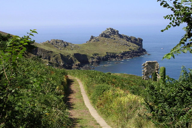
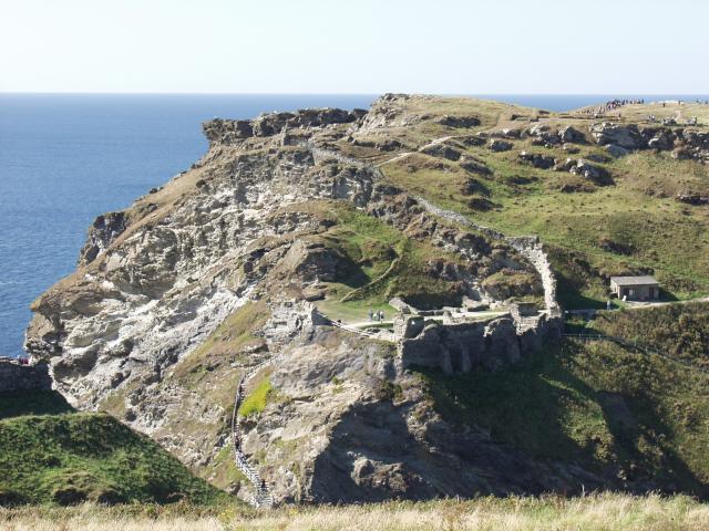
| Tintagel | 3.7 miles (6 km) | Explore the pretty village of Tintagel and visit the spectacular coastal castle. The walk starts in the village and then takes you over a bridge to the island where you enter the courtyard through a gate. Here you will find 18 acres to explore with a garden, chapel, tunnel, well and the remains of the Great Hall.
You continue along the beautiful coast path to Lye rock before returning to the start point in the village. The area is steeped in Arthurian legend with the walk taking you past King Arthur's Hall in Tintagel village. This historic building contains works of art telling the story of King Arthur and is a popular visitor attraction. The South West Coast Path runs past the castle so you could continue your walk along this long distance trail towards Boscastle. View Full Details>> | |
| Trebah Garden | 0.9 miles (1.5 km) | Follow over 4 miles of walking paths in these stunning Cornish gardens. There are 26 acres of sub-tropical gardens to explore and a secluded private beach on the banks of the River Helford. View Full Details>> | |
| Trelissick House and Gardens | 2.5 miles (4 km) | Explore the beautiful 300-acre estate of this National Trust run country house in Cornwall. View Full Details>> | |
| Trengwainton Gardens | 1.2 miles (2 km) | Enjoy a peaceful stroll around these delightful National Trust owned gardens near Penzance. View Full Details>> | |
| Trevose Head | 4.8 miles (7.8 km) | This is a circular walk around a wonderful coastal headland near Padstow with wonderful views along the length of the north Cornwall coast. There's a car park at the north western end of the headland near to the Trevose Head Lighthouse. From here you can pick up the South West Coast Path to take you past the lighthouse and Dinas Head. The path continues around Mother Ivey's Bay to the little village of Harlyn where there is a nice beach at the pretty Harlyn Bay. The bay is a nice place to stop and watch the surfers. From here you can follow country lanes west to Constantine Bay where there's another lovely beach and sand dunes. Head north from here and you will pass Booby's Bay before returning to the car park. Features on the walk include the wild asparagus growing at Dinas Head, interesting rock formations on the cliffs and the secluded bathing beach at Mother Ivey's Bay. Look out for wildlife including fulmar, razorbill and guillemot as you make your way around this beautiful headland. You can extend your walk by continuing east along the coastal path to Stepper Point just north of Padstow. Here you will find the 19th century Daymark Tower and fine views over the Camel Estuary. View Full Details>> | |
| Two Castles Trail | 23.6 miles (38 km) | Follow the Two Castles trail from Devon into Cornwall and enjoy beautiful countryside, woodland and downland. The route starts at Okehampton castle and heads east through Sourton, Stowford, Lewtrenchard and Lifton to Launceston, finishing near Launceston castle. The historic castle has a history dating back to the 11th century. Today the castle is owned by the duchy of Cornwall and operated by English Heritage as a tourist attraction. Much of the castle defences remain, including the motte, keep and high tower which overlook the castle's former deer park to the south. Walk highlights include a lovely stretch along the West Okement river and through Okehampton Golf Course at the start, followed by a walk through Meldon Wood and past Meldon Reservoir. View Full Details>> | |
| Wadebridge | 5.4 miles (8.7 km) | This market town is situated in a lovely spot on the River Camel in North Cornwall. View Full Details>> | |
| Zennor Churchway and Tinners Way | 29.8 miles (48 km) | A circular walk offering splendid views of the Cornish countryside and coast around St Ives and St Just. View Full Details>> |