Nidderdale Walks

Use the links to view full route information including elevation profiles, interactive maps and GPS downloads.
You can also view an overview map of all the routes in the using the Nidderdale Walk Map>>
| Route Name | Photo | Distance | Description |
| Barden Reservoir | 2 miles (2.5 km) | This walk visits the Lower Barden Reservoir on Barden Moor in the Nidderdale area of Yorkshire. View Full Details>> | |
| Beamsley Beacon | 3 miles (5.5 km) | This short climb in the Yorkshire Dales visits Beamsley Beacon which is also known as Howber Hill. The local landmark is located close to the little village of Beamsley in the Craven district of North Yorkshire. You can start the walk from here and then follow a mixture of country lanes and public footpaths to the hill. The summit stands at a height of 326 metres (1,070 ft) and includes a number of stone cairns, dating from the Bronze Age. From the peak there are splendid views over the surrounding hills and countryside including the nearby Chelker Reservoir. You can extend the walk by continuing on to Old Pike. Beamsley is located very close to the wonderful Bolton Abbey. You can extend your walk by following the nature trails along the River Wharfe and it's surrounding woodland. The Dales Way also passes through the area. You could visit the beacon from Ilkley by following the long distance trail along the river to Beamsley village. Our Beamsley Beacon Walk from Ilkley shows an alternative, more direct route to the sumit from the popular town. View Full Details>> | |
| Beamsley Beacon Walk From Ilkley | 9 miles (14 km) | This walk climbs to Beamsley Beacon from the town of Ilkley in Nidderdale. It's about a 4.5 mile walk to the hill top, so about 9 miles in total. It's a lovely area with views of the Nidderdale countryside, some short woodland sections and a riverside footpath to enjoy. The walk starts on Ilkley Bridge over the River Wharfe in Ilkley. Cross to the north side of the river and then follow a waterside footpath west toward Ilkley Golf Club. The route continues north west through Owler Park to Nesfield before coming to West Hall. Here you turn north east to follow the West Hall Beck to Black Foss Farm. A mixture of country lanes and footpaths then take you up to the summit of Beamsley Beacon. The summit stands at a height of 326 metres (1,070 ft) and includes a number of stone cairns, dating from the Bronze Age. From the peak there are splendid views over the surrounding hills and countryside including the nearby Chelker Reservoir. After taking in the views the route then descends back to the town on the same paths. View Full Details>> | |
| Bewerley Industrial Heritage Trail | 9 miles (14 km) | Explore the Pateley Bridge area of Nidderdale, North Yorkshire on this historical circular walk. The trail explores nearly a thousand years of lead mining history while also offering splendid views of the beautiful Nidderdale area. Highlights include the delightful waterfalls at Throstle Nest and Coldstones Cut - a huge artisitic construction which visitors can freely walk through and explore. The sculpture overlooks the working Coldstones Quarry and offers fabulous views of the scenery of Nidderdale in the Yorkshire Dales. View Full Details>> | |
| Birstwith | 3 miles (5.6 km) | This pretty village is located in the Harrogate district of North Yorkshire. Birstwith is a nice place to start a riverside walk around a lovely part of the Nidderdale AONB. View Full Details>> | |
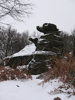
| Brimham Rocks | 3 miles (4.5 km) | Brimham Rocks is a National Trust owned site with a collection of fascinating rock formations. You can explore the labyrinth of paths while enjoying fabulous views over Nidderdale. This circular walk starts from the on site car park where you can pick up trails heading around Brimham Moor where there's pretty heather to see. The trails will take you around the ancient rocks which are hundreds of millions of years old. It's also great for wildlife with a number of bird boxes attracting Blue Tits and Redstarts to nest in the area. The site is located near Pateley Bridge and on the Nidderdale Way walking route so there is scope for continuing your walk through the Nidderdale AONB. View Full Details>> | |
| Chelker Reservoir | 1 miles (2 km) | This walk takes you around Chelker Reservoir and Chelker Windfarm near Addingham in North Yorkshire. It's a very scenic area with the fine views towards the surrounding hills and countryside. The windfarm is notable as only third ever to be installed in their country. View Full Details>> | |
| Circular Walk around Kettlewell | 7 miles (11.5 km) | This challenging circular walk climbs to Great Whernside, Blackfell Top and Blackfell Dike from the popular village of Kettlewell, in the Nidderdale area of the Yorkshire Dales. The route starts in the village and heads along the lovely Dowber Gill Beck where there's a series of pretty waterfalls. You continue to the Providence Pot cave where you turn left to Hag Dike. Turn right here and the path will take you directly up to the Great Whernside summit. It's a splendid viewpoint with views to the Lake District Fells, Pendle Hill, Wharfedale, Buckden Pike and the Pennines. After soaking in the summit views the route descends to Blackfell Top, Black Dike and Tor Dike, where there are more nice views down the valley to enjoy. The final section takes you along Starbotton Road before turning left down Top Mere Road. Follow the track for about 1.5 miles and it will return you to Kettlewell. For a more direct path to the summit try the Great Whernside Walk. The Dales Way long distance trail runs through the village. You could follow it north through Wharfedale to extend your exercise. It's a lovely riverside path which will take you to the village of Buckden where you can try the climb to Buckden Pike. Heading in the other direction will take you to Grassington. You can see more details on the Grassington to Kettlewell Walk. View Full Details>> | |
| Coldstones Cut | 2 miles (3.3 km) | This walk visits the photogenic Coldstones Cut, a huge public artwork on Greenhow Hill in North Yorkshire. View Full Details>> | |
| Druids Temple | 9 miles (15 km) | Visit this fascinating replica of Stonehenge, on this lovely circular walk from Masham. The unusual folly is one of the local highlights and with a series of pleasant footpaths around the site it is a popular destination for walkers. The walk starts in the market town of Masham in the Harrogate district of North Yorkshire. The attractive town has some fine Georgian architecture and has some nice riverside footpaths along the River Ure and River Burn. From the town you head west along the Ripon Rowel long distance trail. It will take you towards Micklebury Hill and across Fearby Moor, with nice views of the River Burn. The route then climbs on to the wooded area where you will find the Druids Temple structure. It was built in about 1820 by William Danby of nearby Swinton Park. The site includes a large stone table, a sheltered cave, and an altar stone. It became a folly of national reputation and is still an impressive sight. Situated at over 800ft there are great views over Wensleydale from the Druid's Plantation surrounding the folly. After exploring the folly and the woodland, the walk then descends to High Knowle and the pretty Sole Beck before picking up the Ripon Rowel to take you back to Masham. To extend the walk you could continue west and visit Leighton Reservoir and Roundhill Reservoir. There's some nice trails along the water and up into the surrounding moorland. Around here you can also pick up the Six Dales Trail. View Full Details>> | |
| Eavestone Lake | 3 miles (5.5 km) | This circular walk in Nidderdale visits Eavestone Lake and the Picking Gill Nature Reserve. The secluded and tranquil lake is something of a hidden gem and a lovely area for a peaceful walk. View Full Details>> | |
| Fewston Reservoir | 3 miles (5.5 km) | Enjoy an easy circular walk around the lovely Fewston Reservoir in the Yorkshire Dales. The path around the reservoir is well surfaced and largely flat so this is a good walk for abilities. The reservoir is surrounded by woodland and beautiful widlflowers including common vetch, betony, milkwork golden rod and common cow-wheat. Also look out for birds on the water including Moorhens, Geese and Ducks. This walk starts at Blubberhouses at the northern end of the reservoir and follows the waterside footpaths around the reservoir. The circular trail runs for a distance of just over 3.5 miles so should take around 1-2 hours to complete. It's easy to extend your walk by heading to the adjacent Thruscross Reservoir. A lovely footpath along the River Washburn will take you there. Swinsty Reservoir is also just to the south and also has an easy circular footpath. Fewston Reservoir is located near to Leeds and Harrogate. View Full Details>> | |
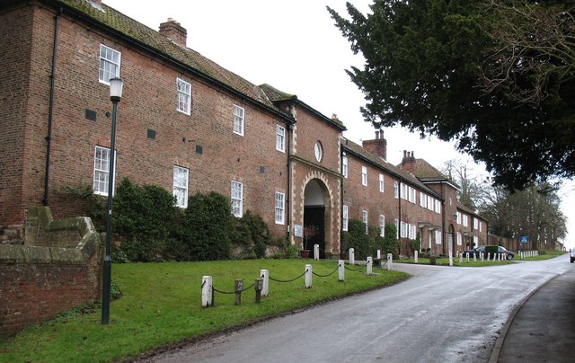
| Goldsborough | 4 miles (6 km) | This village in North Yorkshire is located close to both Harrogate and Knaresborough. There's some interesting history here with a fine old Jacobean Hall and a 16th century pub to investigate. View Full Details>> | |
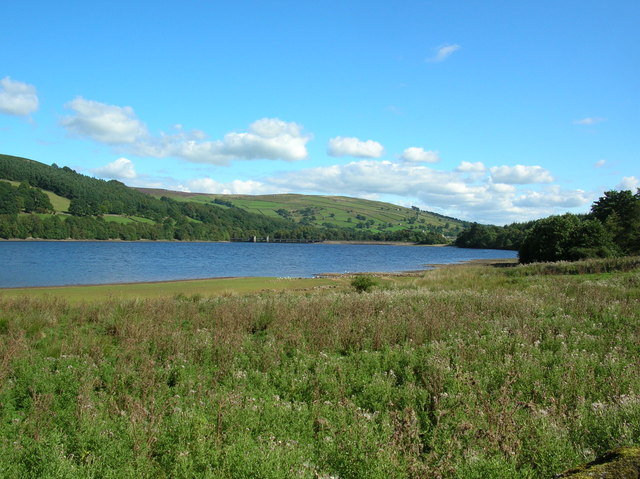
| Gouthwaite Reservoir | 5 miles (8 km) | This walk takes you around this delightful reservoir, near Pateley Bridge and Ramsgill. The route makes use of the Nidderdale Way footpath which runs around the reservoir. It's a super place for birdwatching with three viewing areas on the edge of the reservoir. Look out for great spotted woodpecker and nuthatch in the trees around the water. On the reservoir you can spot goosanders, goldeney, mallard, tufted duck and pochard. Other visitors include buzzard, red kite, hen harriers, merlins and kestrels. This walk starts at the car park on the western end of the reservoir but you could also start at Pately Bridge and follow the River Nidd to the reservoir. To extend your walk you could follow the Nidderdale Way to the spectacular limestone gorge at How Stean Gorge. The Six Dales Trail also passes the through the area. If you follow if north you can cross Fountains Earth Moor and visit the nearby Leighton Reservoir. View Full Details>> | |
| Grassington to Kettlewell | 6 miles (9.5 km) | A linear walk on the Dales Way between these two popular Yorkshire towns. The route includes some wonderful limestone scenery and fabulous, far reaching views from the high points. It's about a 6 mile hike, with some moderate climbs along the way. You pick up the Dales Way in the centre of Grassington and head north, climbing to Lea Green, Old Pasture and Conistone Pie. This unusual limestone outcrop is shaped like a pie and commands great views of Wharfedale and Littondale. The route then descends along Swineber Scar toward Scargill House. The house dates from the eighteenth century and is constructed of stone, rendered and colour-washed, under a stone flag roof. It is now used as a Christian conference Centre run by the Scargill Movement. The route then passes Crookacre barn before coming into Kettlewell. View Full Details>> | |
| Great Whernside | 4 miles (6.5 km) | Climb to this prominent fell on this walk from Kettlewell to Great Whernside in North Yorkshire. Great Whernside forms the watershed between Wharfedale and Nidderdale, and is on the boundary between the Yorkshire Dales National Park and Nidderdale Area of Outstanding Natural Beauty. You can ascend to the 704 m (2,310 ft) summit from the village of Kettlewell. It's about a 2.5 mile climb and considered by many to be one of the best in the Yorkshire Dales. From the summit there are wonderful views of Pen y ghent, Ingleborough, Whernside, Pendle Hill and the Lake Distirct Mountains. This route climbs to the summit directly from Kettlewell, following a footpath to Hag Dike and then on to the summit. You can turn it into a longer circular route by continuing north from the summit to Blackfell Top and Black Dike and then descending to Starbotton Road. See our Circular Walk around Kettlewell for more details. Kettlewell is a pretty little village with a car park where you can start the walk. After your walk there's good pubs and cafes where you can refresh yourself after your exercise. There's lots of good options for extending your walking in the Kettlewell area. The Dales Way runs through the village so you could pick up the long distance path and head south to the market town of Grassington. Here you can enjoy riverside paths along the River Wharfe and a visit to the pretty Linton Falls. Just to the north is the village of Buckden where you can climb to Buckden Pike. View Full Details>> | |
| How Stean Gorge | 3 miles (5 km) | Visit this spectacular limestone gorge and enjoy a walk through the beautiful Nidderdale countryside. You can park in the village of Middlesmoor and then follow footpaths to the gorge about half a mile south. It's great for walkers with lots of public footpaths along the rushing river and through the surrounding woodland. The area also has an activity centre where you can try caving, rock climbing, abseiling and canoeing. After exploring the gorge you could extend your walk by picking up the Nidderdale Way and following it to the nearby Gouthwaite Reservoir or Scar House Reservoir. View Full Details>> | |
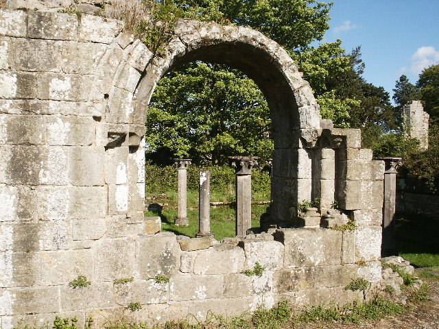
| Jervaulx Abbey | 2 miles (3.2 km) | This walk explores the photogenic ruins of the historic Jervaulx Abbey in North Yorkshire. View Full Details>> | |
| Kettlewell to Starbotton and Arncliffe Walk | 7 miles (11.5 km) | This circular walk from Kettlewell takes you to the neighbouring villages of Starbotton and Arncliffe. There's lovely views of the surrounding Wharfedale and Littondale countryside as you make your way through the area. View Full Details>> | |
| Knaresborough River Walk | 2 miles (3 km) | Enjoy a lovely riverside walk along the River Nidd, from Knaresborough Castle to the nearby Conyngham Hall. The walk runs for just under two miles, starting from the ruins of the 12th century Knaresborough Castle. The 12th century castle sits in a fine location, next to the river, just south of the train station. For a fee you can explore the interior of the castle and visit the interesting museum which details the history of the castle. The grounds include pretty gardens, attractive lawns, a bowling green and a putting green are free to access. From the castle's elevated position there are also fine views over the surrounding area. From the castle head north and then west along the river until you come to High Bridge. Cross to the other side and you can follow footpaths through the woodland on the southern side of the water. After the river bends round to the north you will come to a footbridge where you can cross to Conyngham Hall. There's nice trails to follow around the hall's open parkland, woodland and gardens. After exploring the hall grounds the route then follows the northern side of the river back to the castle. View Full Details>> | |
| Knaresborough Round | 20 miles (32 km) | This 20 mile circular walk takes you on a tour of the countryside, lakes, rivers, woodland and villages surrounding the historic Yorkshire town of Knaresborough. It's a great way to explore this beautiful part of North Yorkshire. The walk starts by the River Nidd near Knaresborough Castle in the town centre. You then follow the river east towards the village of Goldsborough, home to the Grade II* listed Jacobean mansion of Goldsborough Hall. Woodland sections through Great Wood and Parsonage Wood take you to Flaxby and Coneythorpe. The route continues through several small villages around Farnham including Ferrensby, Occaney, Brearton and Scotton where you will enter the wonderful Nidd Gorge. The beautiful river gorge is a real highlight on the walk with lots of interesting flora and fauna to look out for. The final section takes you towards Starbeck and Gallow Hill before returning to the town. This walk joins with the Harrogate Ringway so you can pick up this trail to further explore the area. View Full Details>> | |
| Leighton Reservoir | 6 miles (10 km) | This circular walk visits Leighton and Roundhill Reservoirs before climbing into the surrounding moors for great views back down to the water. You can start the walk from the roadside parking near the bridge and then follow paths along the woodland to Roundhill Reservoir. The route then climbs onto Arnagill Moor, where you will reach a height of over 1200ft. From these high points there are splendid views over the beautiful countryside of Nidderdale. The route then descends through Head Moor before returning to the reservoirs. You could start the walk from nearby Masham if you prefer. Then follow the Ripon Rowel west along the River Burn to the reservoir. The reservoir is located very near to the fascinating Druids Temple. This replica of stonehenge sits on a hill just to the east of the start point for this walk. It's well worth a visit if you have time. The long distance Six Dales Trail also passes the reservoirs. You can pick this up and follow it south across Fountains Earth Moor and visit Gouthwaite Reservoir to extend your exercise. Around here you can also pick up the Nidderdale Way and further explore this lovely area. View Full Details>> | |
| Lindley Wood Reservoir | 2 miles (3 km) | Enjoy an easy walk along this pretty reservoir and wood in the Washburn valley. You can start the walk from the nearby village of Leathley and follow a footpath along the River Washburn to the reservoir. The path takes you along the eastern side of the water with some peaceful woodland trails to enjoy in the adjacent Lindley Wood. Here you will find pretty bluebells in the spring and the rushing waters of Greystone Beck. It's a lovely area with the reservoir surrounded by attractive woodland and the option of continuing your walk along the Washburn to Norwood Bottom. If you enjoy this walk then you could visit Swinsty Reservoir and Fewston Reservoir. These are located a couple of miles north of Lindley Wood in the Nidderdale AONB. Just to the south is the splendid Otley Chevin Country Park where you will find woodland, heathland, meadowland and rocky outcrops with marvellous views. Lindley Wood is located close to Otley and not far from Leeds. In the town you could try our Otley River Walk which take you through some of the riverside parks and nature reserves located on the River Wharfe. View Full Details>> | |
| Littondale | 5 miles (7.8 km) | This circular walk explores lovely Littondale in the Yorkshire Dales. The route runs for just under 5 miles with some small climbs on the way. There's lovely river paths and fine views to the surrounding hills to enjoy. View Full Details>> | |
| Masham | 4 miles (7 km) | A circular walk exploring the countryside and rivers around the small town of Masham in North Yorkshire. The walk includes lovely riverside stretches along the River Burn and the River Ure. You'll also pass close to the Swinton Estate with its deer park and expansive parkland. The route starts in the town centre which includes a nice Market Place and some fine Georgian architecture. You head east from the town to the River Ure, where you pick up a nice riverside footpath. After about half a mile you turn west to pick up a trail along the River Burn. The river passes close to the village of Swinton which includes Swinton Park. The country house is now a hotel set in 200 acres of parkland, lakes and gardens. You can visit the estate, explore the beautiful gardens and watch out for the resident fallow deer. The walk continues past Swinton Moor before picking up a section of the Ripon Rowel long distance trail. You follow the waymarked trail through the countryside to return to the town. To extend your walking around Masham follow footpaths north from the town to the nearby Marfield Wetlands Nature Reserve. The peaceful reserve is home to a variety of species of bird and includes several ponds located next to the River Ure. If you head south you can visit Hackfall Woods and the villages of Grewelthorpe and Kirkby Malzeard. Other walks in the area include the splendid climb to the fascinating Druids Temple. You can follow the Ripon Rowel from the town to the site, where you will find an early 19th century replica of Stonehenge surrounded by attractive woodland. Also near the town is Leighton Reservoir and Roundhill Reservoir. View Full Details>> | |
| Nidderdale Way | 53 miles (85 km) | Explore beautiful Nidderdale in the Yorkshire Dales on this circular walk. The walk includes splendid riverside sections along the River Nidd and waterside sections alongside Scar House Reservoir and Gouthwaite Reservoir. The delightful town of Pateley Bridge is a good access point and just a short walk along the River Nidd leads you to one of the main attractions on the route at Gouthwaite Reservoir. Also of interest is the impressive How Stean Gorge and the 15th century Ripley Castle. The castle, and the landscaped grounds are open to the public. View Full Details>> | |
| Pateley Bridge Circular Walk | 11 miles (18 km) | This circular walk around the Yorkshire town of Pateley Bridge makes use of the Nidderdale Way to take you on a tour the countryside, reservoirs, rivers and woodland surrounding the town. It's just over 12 miles in length so it's one you can complete in a day. The town is an excellent base for walks in the Nidderdale area. It is also home to the oldest sweet shop in England and the fascinating Nidderdale Museum. The route starts in the centre of the town and follows the River Nidd north to Gouthwaite Reservoir, passing the village of Wath-in-Nidderdale on the way. The path then heads along the water to Ramsgill with great views across the reservoir. Gouthwaite is very popular with birdwatchers with goosanders, goldeney, mallard, tufted duck and pochard to look out for on the water. At Ramsgill you will find the Yorke Arms, a Michelin-starred restaurant on the village green. Here you turn south along the western side of the reservoir to Heathfield. The walk then heads along the pretty Ashfold Sidebeck towards Pinnacle Hill. On this section of the walk you reach a height of almost 1000ft so there are some really wonderful views over the Yorkshire Dales to enjoy. The final section descends past Pincher Hill with a short woodland section here also. Shortly after you return to the finish point back in Pateley. There are many other great walks around Pateley Bridge to try. You can pick up the Six Dales Trail and explore Wharfedale, Washburndale, Colsterdale, Coverdale, and Wensleydale. The Bewerley Industrial Heritage Trail also passes through Pateley. The fascinating trail explores nearly a thousand years of lead mining history. View Full Details>> | |
| Ripley Castle | 1 miles (2.2 km) | Explore the grounds of this Grade I listed 14th-century country house on this circular walk in Ripley, North Yorkshire. View Full Details>> | |
| Scar House Reservoir | 4 miles (6 km) | This circular walk takes you around Scar House Reservoir to Angram Reservoir in Nidderdale. The reservoir has a well surfaced footpath running around the perimeter and a car park at the eastern end. It runs for nearly 4 miles and is fairly flat so will suit most abilities. The surrounding countryside is beautiful with views of the Yorkshire Hills and the River Nidd. You can easily extend your walk by picking up the Nidderdale Way and heading along the river. Following the trail south will take you to Middlesmoor where you can visit the wonderful How Stean Gorge. View Full Details>> | |
| Six Dales Trail | 38 miles (61 km) | This stunning walk passes through six of the beautiful Yorkshire Dales - Wharfedale, Washburndale, Nidderdale, Colsterdale, Coverdale, and Wensleydale. The walk runs from Otley to Middleham passing through the Nidderdale AONB. It includes riverside stretches along the River Washburn near the start of the walk, the River Nidd near Pateley Bridge and the River Ure towards the end of the walk at Middleham. You will also pass a series of lovely reservoirs including Fewston Reservoir, Gouthwaite Reservoir and Leighton Reservoir. One of the chief highlights on the route is Jervaulx Abbey - a 12th century former Cistercian monastery it now stands as an enchanting, atmospheric ruin. Also of interest is the English Heritage owned Middleham Castle where there are fantastic views of Wensleydale from the fascinating site. View Full Details>> | |
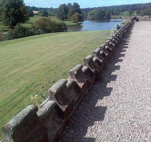
| Studley Park and Fountains Abbey | 4 miles (7 km) | This marvellous attraction boasts 800 acres of beautiful parkland set in the Yorkshire countryside. Explore the beautiful landscaped Georgian water garden of Studley Royal, before heading to the fascinating 12th-century Fountains Abbey. Look out for beautiful statues, follies and the many resident deer in the deer park. The ancient corn mill, the 17th century Fountains Hall and the Victorian Gothic church are also well worth a look. The park is located just to the west of the North Yorkshire city of Ripon on the edge of the Nidderdale AONB. The Ripon Rowel long distance footpath passes the park so you can pick this up to extend your walking in the area. Heading south will take you through the countryside to Ingerthorpe and Markington. Just to the east you can pick up the towpath of the Ripon Canal and enjoy an easy walk to Newby Hall. The 18th century house is well worth a visit, with its splendid gardens and views over the River Ure. View Full Details>> | |
| Summerbridge | 6 miles (9 km) | This pretty riverside village is a nice place to enjoy a walk through the surrounding countryside of the Nidderdale AONB. View Full Details>> | |
| Swinsty Reservoir | 3 miles (5 km) | This is a nice, easy circular walk around Swinsty Reservoir in the Yorkshire Dales. The path is well surfaced and largely flat making the walk suitable for all abilities. The trail runs for a distance of about 3 miles so it's perfect for a peaceful afternoon stroll. The walk starts at the car park on the eastern side of the reservoir and follows the footpath through woodland to the Fewston Embankment, passing Fewston on the way. You head along the Fewston Embankment with splendid views of both Swinsty Reservoir and the adjacent Fewston Reservoir. A woodland section through the Swinsty Moor plantation then takes you to Swinsty Hall, before coming to the Swinsty Embankment with great views of the River Washburn Valley to the south. A short waterside section past more woodland then returns you to the car park. It's easy to extend your walking in this lovely area by heading to the nearby Fewston Reservoir, Thruscross Reservoir and Lindley Wood Reservoir for more waterside walks. View Full Details>> | |
| Swinton Park | 2 miles (3.4 km) | Explore the Swinton Estate on this circular walk in North Yorkshire. View Full Details>> | |
| Thruscross Reservoir | 5 miles (8 km) | This is a delightful waterside walk around Thruscross Reservoir in the Yorkshire Dales. It's a beautiful area with the tranquil waters of the reservoir surrounded by peaceful woodland and beautiful countryside. The circular route runs for a distance of about 5 miles with small hill climbs long the way. As such it should take just under 2 hours to walk all the way around. The walk begins at the car park at the southern end of the reservoir and takes you along a good footpath to Whit Moor, Far Comb Hill and past the hugely impressive dam. It is a fairly easy walk with woodland sections, waterside sections and some moderate climbs. Highlights include the impressive Washburn Dam near the start. This historical landmark makes for a great photo. Thruscross is located near to Leeds and Harrogate. You can easily extend your walk by heading to the adjacent Fewston Reservoir. A riverside footpath along the River Washburn will take you there. Swinsty Reservoir is also just a little further south and offers a shorter walk. View Full Details>> | |
| West and East Witton | 17 miles (27 km) | This circular walk takes you between the villages of West and East Witton in North Yorkshire. On the way there's some lovely Wensleydale scenery and visits to Coverham Abbey and Jervaulx Abbey. There's also some nice waterside sections along the River Cover and River Ure to enjoy. View Full Details>> | |
| Whernside | 8 miles (13 km) | Climb to the highest point in North Yorkshire on this challenging circular walk in the Yorkshire Dales. Whernside is one of the Yorkshire Three Peaks, with the others being Ingleborough and Pen y ghent. The route runs for a distance of just under 8 miles with a steep ascent and descent, meaning a good level of fitness is required. The circular walk begins at Ribblehead and heads to the Blue Clay Ridge via the magnificent Ribblehead Viaduct. You continue your ascent passing the pretty Little Dale Beck and Force Gill where you can see a series of waterfalls. The route then passes Knoutberry Hull and a small tarn before arriving at the 736 m (2,415 ft) Whernside summit. From here there are fantastic views over the Yorkshire Dales, the Lake District and Morecambe Bay. From the summit you descend to Broadrake before crossing the lovely Winterscales Beck. You then follow the beck to Gunnerfleet Farm, and on to the finish point at Ribblehead. To extend your walking in the area you could try our easy circular walk around the magnificent Ribblehead Viaduct. The Grade II* listed structure is one of the England's greatest monuments to Victorian engineering. The long distance Dales Way and Ribble Way both pass near to the mountain so you could pick up these splendid trails to further explore the area. View Full Details>> |