Nottinghamshire Walks

Use the filter to show walks of a certain type such as woods, reservoirs, hills, long distance, country parks, canals and rivers.
In the spring walkers flock to the beautiful bluebell woods in the Nottinghamshire area. Click the 'Woodland' button below to see these.
Use the links to view full route information including elevation profiles, interactive maps and GPS downloads.
You can also view an overview map of all the routes in the using the Nottinghamshire Walk Map>>
*New* - Walks and Cycle Routes Near Me Map - Waymarked Routes and Mountain Bike Trails>>
| Filter: |
| Route Name | Photo | Distance | Description |
| Attenborough Nature Reserve | 3.7 miles (6 km) | Explore over 350 acres of lakes, wetland, woodland, grassland and scrub in this popular nature reserve near Nottingham. The reserve sits at the confluence of the River Erewash and the River Trent and contains several large lakes which attract a wide variety of birdlife. Look out for kingfisher, shoveler, diving ducks and herons. It is located right next to Attenborough train station and on the Trent Valley Way walking route, so you have the option of continuing your walk on this riverside footpath. The Erewash Valley Trail cycle and walk trail also passes through the reserve so you could pick this up. View Full Details>> | |
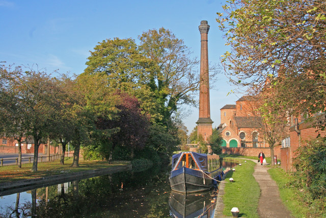
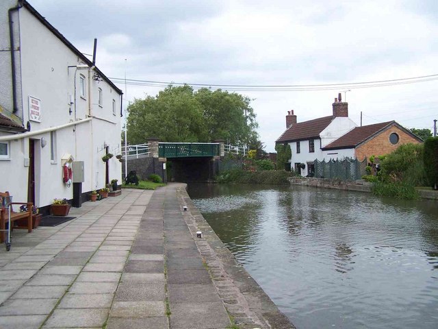
| Beeston Canal | 4.1 miles (6.6 km) | This walk takes you along the Beeston Canal in Nottingham. The towpath along the canal was completed in 1982 and is now used as an easy cycle or walking route. View Full Details>> | |
| Bestwood Country Park | 4.3 miles (7 km) | Bestwood Country Park is located on the outskirts of the city of Nottingham and consists of 650 acres of open green space. The park includes Mill Lakes, where you can follow the waterside trail and look out for the wide variety of water birds that visit the park. There are also wildflower meadows and peaceful forest trails through ancient oak woodland to enjoy. National Cycle Route 6 runs along Mill lakes and the Robin Hood Way walking trail also runs right through the park. You could follow the trail to the nearby Burntstump Country Park for more pleasant woodland walking trails. Following the trail west would take you to the lovely Collier's Wood Nature Reserve and Moorgreen Reservoir. View Full Details>> | |
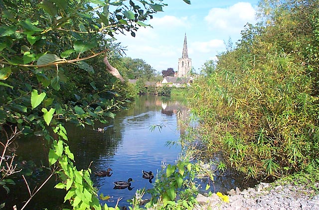
| Bingham Linear Walk | 2.4 miles (3.8 km) | This Nottinghamshire based market town is well positioned for exploring the countryside of the River Trent Valley. View Full Details>> | |
| Blidworth Woods | 3.1 miles (5 km) | Explore the pine woodlands and open heath of Blidworth Woods, on this peaceful walk in Sherwood Forest. View Full Details>> | |
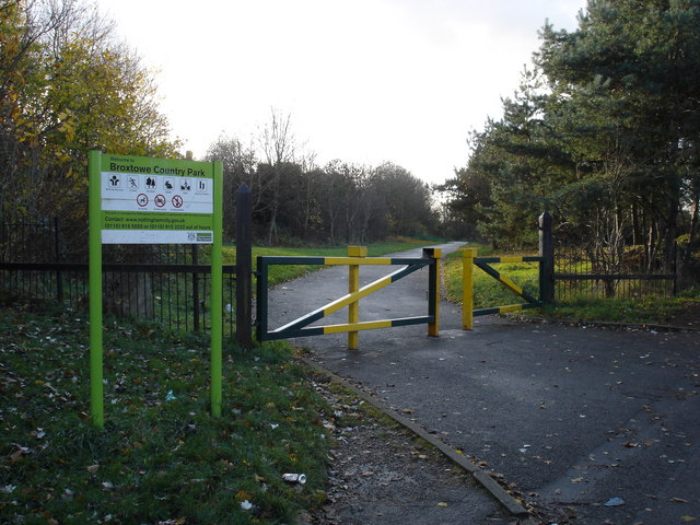
| Broxtowe Country Park | 1.6 miles (2.5 km) | This country park in Nottingham has some nice cycling and walking trails to try. The park covers 46 hectares and includes nice surfaced trails, open grassland and woodland areas with bluebells in the spring. There's also lots of pretty wildflowers and woodland birds to look out for. Keep your eyes peeled for Green woodpeckers and Ramsons (wild garlic). The park is also home to a great BMX track with tracks and jumps to cater for all ages and abilities. To continue your exercise you could head to West Bridgford and visit Holme Pierrepont Country Park and Colwick Country Park for more nice cycling and walking paths. View Full Details>> | |
| Burntstump Country Park | 1.9 miles (3 km) | Explore open grassland, woodland and glade in this country park in Nottingham. In the park you will find peaceful woodland walking trails, an ornamental pond and the Burntstump Inn where you can enjoy refreshments. The pub overlooks the cricket field so it's a nice place to relax on match days. View Full Details>> | |
| Car Colston | 2.2 miles (3.6 km) | This Nottinghamshire based village is located in the Rushcliffe borough of the county. View Full Details>> | |
| Clumber Country Park | 5 miles (8 km) | Enjoy a peaceful walk or cycle around the fabulous Clumber Park in Worksop. Clumber Park contains over 3,800 acres of woodland, open heath and rolling farmland. There is also a beautiful serpentine lake and a picturesque avenue of lime trees that runs for 2 miles. Also of interest is the picture postcard Hardwick Village, the Gothic Clumber Chapel and the Walled Kitchen Garden. The route below is devised for walkers but the park is excellent for cycling, particularly around the lake area. You can hire bikes and pick up route guides from within the park - please click here for more information. The routes are nice and safe so ideal for families. National Cycle Route 6 also passes through the park linking it to Sherwood Forest - see the Nottingham to Worksop cycle route for more information. You can also visit the park from nearby Mansfield using the signed route. Our Mansfield Cycle Route starts just east of the town at the lovely Vicar Water Country Park. It's a nice way to visit both parks on your bike in a day. To extend your walking in the area you could follow the Robin Hood Way north west from the park and visit the nearby Welbeck Estate. Here you'll find two pretty lakes and a large deer park with resident white deer. View Full Details>> | |
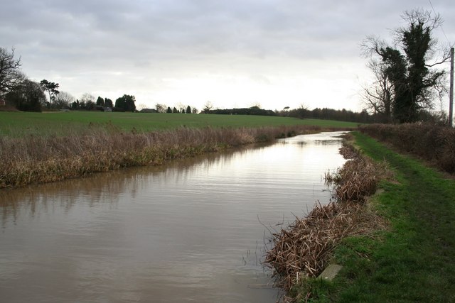
| Collingham | 4.3 miles (7 km) | The Nottinghamshire village of Collingham is located in a nice rural location close to the River Trent. View Full Details>> | |
| Colwick Country Park | 2.5 miles (4 km) | Enjoy several miles of lovely, waterside walking and cycling in this country park in Nottingham. The park contains two large lakes, a marina, woodland and meadows. The River Trent also runs through the park so there is scope for continuing your walk along the Trent Valley Way walking route. There is also an excellent visitor centre with cycle hire available. To extend your exercise you could visit the nearby Holme Pierrepont Country Park where there are more good cycling and walking trails. You could also head to Broxtowe Country Park where there's some nice woodland trails and a BMX track to try. The park is located to the south of Nottingham city centre near to Nottingham Midland Railway station. View Full Details>> | |
| Cotgrave Country Park | 2.2 miles (3.5 km) | This lovely country park near Nottingham is the perfect place for a peaceful cycle or walk. The park includes woodland, wetland, lakes and informal grassland while the Grantham canal also runs through the park. You could continue your exercise along the Grantham Canal and visit the nearby village of Hickling where there's a nice canalside pub. If you head a couple of miles north where you'll find the Holme Pierrepont Country Park and Colwick Country Park. View Full Details>> | |
| Creswell Crags | 0.9 miles (1.5 km) | This walk takes you around this fascinating limestone gorge on the Derbyshire and Nottinghamshire border. There's a lovely waterside footpath running along Crags Lake with views of the surrounding caves and cliffs. It's a well surfaced trail taking you up close to the remarkable geological features in the park. There is an excellent visitor centre with a museum detailing the history of the caves and fissures. You can see bones of lynx, beaver and wild pig dating from the last Ice Age 9,500 years ago. There's also some fascinating Cave Art, with engravings and bas-reliefs found on the walls and ceilings of some of the caves as recently as 2013. It's a very important find as it had previously been thought that no British cave art existed. If you'd like to extend your walk you could pick up the Robin Hood Way which runs through the park. A few miles to the north you will find the lovely Whitwell Wood which has three waymarked walking trails to try. Just to the east of the crags you will find the lovely Welbeck Estate. Here you can follow the Robin Hood Way between the two pretty lakes and into the adjacent woodland. There's also a large deer park with resident white deer to look out for. You can reach the deer park by heading south east along the Robin Hood Way from the western end of Cresswell Crags. View Full Details>> | |
| Cuckoo Way | 46 miles (74 km) | This walk follows the Chesterfield Canal through Nottinghamshire, South Yorkshire and Derbyshire from Chesterfield to West Stockwith. You will pass 36 locks and 11 bridges as you walk along one of England's most beautiful waterways. The walk passes Stavely, Retford and Worksop while there is also a pleasant section around the lovely Rother Valley Country Park at Killamarsh. Here you will find 5 lakes and a nature reserve which boasts the recording of over 260 different varieties of birds over the past two decades. Just south of Rother Valley Country Park you will pass the splendid Renishaw Hall at Eckington's. Here you will find a large country house surrounded by beautiful gardens, parkland, woodland and lakes. Around Retford the splendid Idle Valley Nature Reserve is well worth a small detour. View Full Details>> | |
| Daneshill Lakes | 1.1 miles (1.7 km) | This easy walk takes you around the lovely Daneshill Lakes Nature Reserve near Retford. There's wetlands, woodland, grassland, flowering plants and lots of wildlife to look out for on the site. Look out for grebes, swans, willow warbler, whitethroat, and blackcap on your walk. There's a free on-site car park from which you can start the walk. To the south there's the more popular open water section, while to the north there's some peaceful woodland trails to enjoy. View Full Details>> | |
| East Leake | 5 miles (8 km) | This pretty Nottinghamshire village has a picturesque green, a selection of waymarked country trails and a fine local farm to visit. There's also some fine old pubs and a noteworthy 11th century church to see in the village. View Full Details>> | |
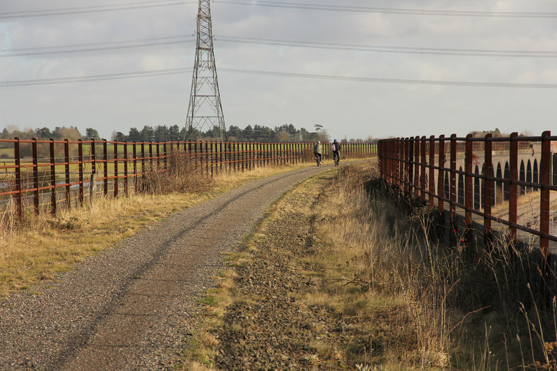
| Erewash Canal | 11.8 miles (19 km) | Follow the Erewash canal through south Derbyshire on this waterside cycling and walking route. The canal runs from Trent Lock near Long Eaton to the Langley Mill (Great Northern) basin. You can follow the towpath all the way on your bike or on foot. It's a nice easy route that runs for about 12 miles so it's a good family cycle ride or long walk. On the way you'll pass old mills, pretty locks and a number of stone bridges. The areas around Nutbrook Junction and Trowell Marsh are nature reserves where you can look out for a wide variety of wildlife. There's also nice views of the River Erewash and the surrounding countryside. The canal forms part of the larger Erewash Valley Trail so it's easy to extend your exercise on this circular route. You start off at Trent Lock on the border of Derbyshire, Leicestershire and Nottinghamshire. It's a major canal junction where several significant waterways meet including the River Soar, the Trent and Mersey Canal, the River Trent and the Erewash Canal. The canal then weaves its way through the town of Long Eaton to Sandiacre. You continue north to Ilkeston, passing Gallows Inn and the impressive Bennerley Viaduct, before finishing at Langley Mill at the basin of the Erewash Canal. You can virtually follow part of the route along the canal from Trent Lock by clicking on the google street view link below. To continue your walking in the area you can visit the lovely Attenborough Nature Reserve which is located near the start of the canal at Long Eaton. You can follow the Trent Valley Way along the River Trent to reach the reserve. The Beeston Canal can also be picked up at the eastern end of the reserve, next to the pretty Beeston Lock. The canal also forms part of the Nutbrook Trail Cycle Route which runs up to Shipley Country Park on a dismantled railway line. View Full Details>> | |
| Erewash Valley Trail | 28 miles (45 km) | This splendid cycling and walking trail explores the canals, countryside, towns and villages of south Derbyshire and Nottinghamshire. It's a circular route with miles of great traffic free sections so it's ideal for families or anyone looking for a safe cycle ride. Walkers can also enjoy the nice surfaced trails along the canals and through the nature reserves on this varied route. As a circular route there are several options for a start point. This route starts at Trent Lock on the Erewash Canal just south of the town of Long Eaton. Trent Lock is a significant canal junction where the River Soar, the Trent and Mersey Canal, the River Trent and the Erewash Canal meet (you can virtually explore this section on the street view link below). You then follow the canal towpath north through the town of Long Eaton to Sandiacre. You continue to Ilkeston, passing Gallows Inn and the impressive Bennerley Viaduct, before coming to Langley Mill at the basin of the Erewash Canal. It's a nice section with lots of pretty locks, stone bridges and views of the River Erewash. At Langley Mill you turn south and pick up the Nottingham Canal heading to Cossal and Trowell. The disused canal has now been declared as a nature reserve which attracts lots of dragonflies, damselflies and birdlife. The canal leads you towards Stapleford Hills and Bramcote Hills Park. The park includes a mix of woodland and parkland with a nice walled garden. You'll also pass the geologically fascinating Hemlock Stone. The stone is an outcrop of New Red Sandstone, deposited more than 200 million years ago in the Triassic Period. It's worth stopping to have a look at the plaque and stone on Stapleford Hill before continuing. From the park you continue through Stapleford and Chilwell to the lovely Attenborough Nature Reserve. Here you'll find 350 acres of lakes, wetland, woodland, grassland and scrub with a huge variety of wildlife to look out for. The Beeston Canal can also be picked up at the eastern end of the reserve, next to the pretty Beeston Lock. The final waterside section takes you along the River Trent to Trent Lock and the finish point. Towards the end of the route you pass along the Trent Valley Way so this is a good option if you would like to continue your walking in the area. The trail also forms part of the Nutbrook Trail Cycle Route which runs along the Erewash Canal before bearing right near Stapleford and heading up to Shipley Country Park on a dismantled railway line. View Full Details>> | |
| Felley Priory | 0.6 miles (1 km) | This walk visits the historic Felley Priory near Underwood in Nottinghamshire. View Full Details>> | |
| Fledborough Viaduct | 5.2 miles (8.3 km) | This walk visits the impressive Fledborough Viaduct in Nottinghamshire. View Full Details>> | |
| Gedling Country Park | 2.5 miles (4 km) | Enjoy a series of well laid out cycling and walking trails in this 240 acre country park in Nottingham. There are four colour coded routes of varying lengths and difficulty. Features in the park include a large lake, woodland and great views over the surrounding Nottinghamshire countryside. It's also great for birdwatching - look out for short eared owls, skylarks and lapwings. The park also has food facilities with two car parks and picnic tables. View Full Details>> | |
| Grantham Canal | 32.3 miles (52 km) | A lovely peaceful walk alongside the Grantham Canal from Grantham to Nottingham. The walk takes you through through the glorious Vale of Belvoir and passes Woolsthorpe, Redmile, Harby, Hickling, Gamston and the delightful Cotgrave Country Park. View Full Details>> | |
| Gunthorpe | 5.7 miles (9.2 km) | This village near Nottingham is a popular place for riverside strolls. It's located in a lovely rural spot on the River Trent just a few miles east of the city centre. With some pleasant countryside, a pretty lock and a riverside hotel for post walk refreshments its the ideal place for a scenic walk near the city. View Full Details>> | |
| Hodsock Priory | 3.3 miles (5.3 km) | This circular walk takes you around Hodsock Priory in the Nottinghamshire village of Hodsock. View Full Details>> | |
| Holme Pierrepont Country Park | 3.1 miles (5 km) | Enjoy a waterside walk or cycle in this splendid 270 acre country park in Nottingham. The park includes several large lakes and the delightful Skylark Nature Reserve. You can hire a bike or just go for a stroll along the lovely, lakeside paths. The River Trent also runs through the park so there is scope for continuing your walk along the Trent Valley Way walking route. Adjacent to Holme Pierrpont is Colwick Country Park which is another option for extending your outing. You could also head to Broxtowe Country Park where there's some nice woodland trails and a BMX track to try. The park is the home of the National Watersports Centre so you could have a go at kayaking or windsurfing. Holme Pierrepont is located just to the south of Nottingham city centre. View Full Details>> | |
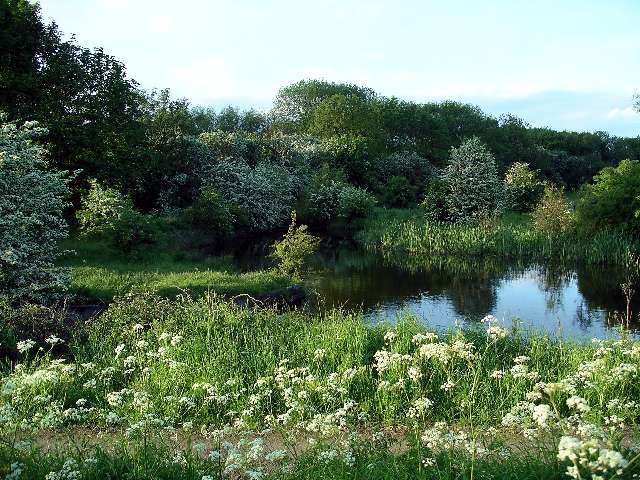
| Idle Valley Nature Reserve | 8.1 miles (13 km) | This splendid nature reserve in Retford has several waymarked walking trails to try. There's lots to see with waterside walks along several pretty lakes and the River Idle which runs right through the site. The expansive reserve covers 450 hectares with hundreds of species of wetland birds to look out for. These include gadwall, wigeon, pochard, lapwing and redshank. There's also streams, woodland trails and lots of interesting plants and flowers to enjoy. You can park at the car park just off the Great North Road at the southern end of the site. From here you can pick up the trails around the lake to the River Idle. There's several colour coded trails to try of varying lengths. Facilities include the Idle Valley Rural Learning Centre and a childrens bronze rubbing trail. This circular route is designed for walkers but there are bridleways and country lanes running through and around the site which are suitable for cyclists. View Full Details>> | |
| Kings Mill Reservoir | 1.2 miles (2 km) | This lake in Mansfield has a nice walking trail to follow around the perimeter of the water. View Full Details>> | |
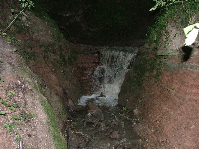
| Lambley Dumbles | 1.5 miles (2.4 km) | This walk explores the delightful Lambley Dumbles in Nottinghamshire. The area is a lovely place for a walk with streams, waterfalls, ancient woodland and lots of interesting geology and flora to see. View Full Details>> | |
| Langold Lake Country Park | 3.1 miles (5 km) | Enjoy woodland, wildlife meadows and two pretty lakes in this 300 acre country park near Worksop. The walk starts at the car park and takes you along Langold Lake and through Dyscarr Woods before returning to the start point. There's also plenty of wildlife to see with the park designated as a Local Nature Reserve. The park is great for children with a play area and water park for them to splash about in. View Full Details>> | |
| Laxton | 8.1 miles (13 km) | This pretty village in Nottinghamshire is a nice place for country walks or a village stroll. View Full Details>> | |
| Mansfield | 1.6 miles (2.5 km) | The area surrounding the market town of Mansfield has some excellent choices for walkers. There's fine woodland trails in the nearby Sherwood Forest, several country parks, riverside trails and a pretty reservoir on the outskirts of the town. This short walk visits Titchfield Park, Kings Mill Reservoir and the River Maun which runs through the town. You'll pass old mills and pretty nature reserves with lots of wildlife to look out for on the way. The route starts just to the south of the train station in Titchfield Park. It's a lovely place for a stroll with riverside paths and a nice cafe. Follow the paths west past St Mark's Church where you pick up the Quarry Lane Walkway and the Timberland Trail. The trail runs along the train line before coming to Kings Mill Reservoir. The site includes an excellent visitor centre and a nice walking trail to follow around the perimeter of the water. There's also lots of wildfowl to look out for on the water. View Full Details>> | |
| Midshires Way | 224.9 miles (362 km) | This route follows public bridleways and quiet country lanes through Middle England, from Bledlow, near Aylesbury in Buckinghamshire, to Stockport in Greater Manchester. The path links The Ridgeway National Trail with the Trans Pennine Trail passing through the countryside of Buckinghamshire, Northamptonshire, Leicesteshire, Nottinghamshire and the Derbyshire Peak District National Park. Highlights include waterside sections along the Grand Union Canal, the Peak Forest Canal and the River Ouse. There is a splendid wooded section through Salcey Forest near Northampton where you could try the Tree Top Trail. View Full Details>> | |
| Moorgreen Reservoir | 2.5 miles (4 km) | This short walk visits Colliers Wood Nature Reserve before following footpaths to the nearby Moorgreen Reservoir. The walk starts in the Colliers Wood car park just to the south of the reservoir. Here you can follow footpaths around the reserve's pond and woodland. It's a small reserve but very pretty, with lots of interesting flora and fauna. The large pond is a lovely place to have a picnic and look out for wildlife. After exploring the surfaced paths of the reserve you then pick up the Broxtowe Country Way and follow it north along the B600 to the reservoir. Here you can follow more woodland trails through High Park Wood along the eastern side of the water before returning on the same path. To extend your walk head east into the extensive woodland next to the reservoir. There's miles of tracks taking you into Morning Springs Wood near Beauvale village. The long distance Robin Hood Way runs just to the south east of the reserve. If you pick this up and head east you can visit the pretty Mill Lakes in Bestwood Country Park. View Full Details>> | |
| Newark River Walk | 0.9 miles (1.5 km) | Enjoy a short stroll around the riverside park in Newark on Trent on this easy walk in Nottinghamshire. There's much to see in this interesting and picturesque area including the Town Lock, Newark Castle, Trent Bridge and the Millgate Museum. The walk starts from the parking area at the riverside park but you could also start from the nearby Newark Castle railway station. The park has nice footpaths taking along the river to the Town Lock. Here you will find a nice sensory garden and lots of old buildings which have now been converted into cafes and shops. The walk then crosses the river and heads to Newark Castle. The castle is a Scheduled Ancient Monument and includes a ruined gatehouse dating from the 12th century. It's in a lovely riverside location with quiet Victorian gardens and access to the castle's walls and dungeons. After exploring the castle the walk then crosses the Trent Bridge to return you to the riverside park and the finish point of the walk. View Full Details>> | |
| Newstead Abbey | 5.6 miles (9 km) | Explore the extensive parkland surrounding this former Augustinian priory and home to Lord Byron. This circular walk starts at the village of Linby and takes you to Papplewick Hall where you join the Robin Hood Way. This takes you north passing the Lower Lake before a woodland stretch through Abbey Wood. You then turn west, passing Newstead Abbey and the Upper Lake. You continue through farmland to Freckland Wood where you turn south and return to Linby. The abbey grounds are truly beautiful with lakes, ponds, cascades and the River Leen all major highlights. There are also a number of beautifully laid out gardens including a Japanese Garden, a Rose Garden, a Sub-Tropical Garden and a French Garden. Look out for wildlife that includes peacocks, swans and geese. You can also tour the fascinating house which was originally founded as a monastery in the 12th century. You can find out all about the Abbey's early history by visiting the medieval cloisters, Chapter House (now the Chapel) and the collection of medieval stone carvings and manuscripts. Lord Byron lived in the house in the early 19th century. You can view the Byron collection of objects, furniture, letters and manuscripts to gain an understanding of his time at Newstead. View Full Details>> | |
| Nottingham Canal | 8.1 miles (13 km) | Enjoy a walk or cycle along this pretty canal in Nottingham. The route runs along the Erewash Valley Trail from Langley Mill to the outskirts of Nottingham. It's a nice flat ride which is ideal for families. The route starts at Langley Mill and heads south to Cossall and Trowell. This area has now been declared as a nature reserve which attracts lots of dragonflies, damselflies and birdlife. On the Trowell section are the remains of Swansea bridge, one of the original stone bridges, which was built around 1793–95. From here you can see the original stone built lock keepers cottages. The route finishes very close to Wollaton Park where you can extend your outing. View Full Details>> | |
| Nottingham Circular Walk | 18 miles (29 km) | This long circular walk makes use of various waymarked footpaths to take you on a tour of the city's rivers, canals, nature reserves and parks. The walk starts at the train station and heads a short distance south to the River Trent. You then follow the Trent Valley Way along the river to the Attenborough Nature Reserve. Here you can explore over 350 acres of lakes, wetland, woodland, grassland and scrub with a huge variety of wildlife to look out for. The Beeston Canal can also be picked up at the eastern of the reserve, next to the pretty Beeston Lock. The walk then heads north, away from the river, towards Chilwell and Stapleford where you climb to Stapleford Hill Park. Here you will find the Hemlock Stone, an outcrop of New Red Sandstone, deposited more than 200 million years ago in the Triassic Period. The walk then heads east towards Wollaton Park. The park includes an exquisite Elizabethan mansion surrounded by acres of parkland, woodland, lakes, formal gardens and the deer park. The final section takes you along the Nottingham Canal to the train station and the finish point. To extend your walking in the city, head east along the river and visit Colwick Country Park and Holme Pierrepont Country Park. These two nice parks have waterside trails around a series of lakes and waterways. The long distance Robin Hood Way and Erewash Valley Trail also pass through the city. View Full Details>> | |
| Retford | 14.9 miles (24 km) | This attractive Nottinghamshire market town has some nice waterside walks along the Chesterfield Canal and the River Idle which run through the area. View Full Details>> | |
| Robin Hood Way | 106.9 miles (172 km) | Follow in the footsteps of this legendary figure on this super walk through Sherwood Forest and the Nottinghamshire countryside. On the route:
| |
| Rufford Abbey Country Park | 3.1 miles (5 km) | Visit Rufford Country Park near Mansfield and explore 150 acres of historic parkland. In the park you will find a medieval monastery, a craft centre, formal gardens, woodland walks, a sculpture trail and a lake. Rufford park once formed part of a 12th century Cistercian abbey and its estate. It is now a country house estate surrounded by beautiful gardens and parkland open to the public. View Full Details>> | |
| Rushcliffe Country Park | 1.9 miles (3 km) | Explore over 200 acres of cycling and walking trails in this popular country park in Ruddington near Nottingham. In the park you will find wildflower meadows, grassland, conservation and landscaped areas. There is also a 2 hectare lake where you can see mute swans, great crested grebes and various duck species. Also look out for skylarks, finches, cuckoos, kestrels, sparrow hawks, reed buntings, reed warblers and sedge warblers. View Full Details>> | |
| Sherwood Forest Country Park | 6.2 miles (10 km) | Explore 450 acres of peaceful woodland in this famous park and Nature Reserve in Nottinghamshire. In Sherwood Forest you'll pass the 800 year old Major Oak which is rumoured to be the base of Robin Hood. There are also excellent facilites with a Visitor Centre and cafe. This circular trail runs for about 6 miles using the waymarked paths around the visitor centre which is located just north of Edwinstowe. There's a good sized car park located here too. There are numerous cycling and walking tracks running through the park with National Cycle Route 6 passing through the centre of the park (see the Nottingham to Worksop Cycle Route). The Robin Hood Way Walk also passes right through the park. Our Mansfield Cycle Route passes through the park and will take you to the nearby Clumber Park where there's miles of nice trails and a beautiful lake. View Full Details>> | |
| Sherwood Pines Forest Park | 5 miles (8 km) | Enjoy several waymarked cycling and walking trails in this large woodland area in Mansfield. View Full Details>> | |
| Silverhill Wood | 2 miles (3.2 km) | Climb to the highest point of Nottinghamshire on this pleasant walk around Silverhill Wood Country Park. The park was built on two former colliery sites and includes a series of good footpaths taking you to woodland, ponds and an excellent viewpoint with fine views over the surrounding area. The walk starts from the car park which is on Silverhill Lane at the southern end of the site. From here you can pick up the woodland trails taking you up to the 204.3 m (670 ft) summit where there's lovely views over 5 counties. You can also see Lincoln Cathedral and the parkland of the nearby Hardwick Hall. The summit includes a bronze statue named 'Testing for Gas' which depicts a kneeling coal miner with a Davy lamp. The statue commemorates coal mining at the 85 Nottinghamshire collieries. After taking in the views the route descends to the two pretty ponds on the eastern side of the site. From here it's a short walk back to the car park. The park is great for wildlife. Look out for deer, butterflies, buzzard, kestrel and green woodpecker as you make your way around the site. This route is designed for walkers but there are tracks suitable for cyclists as well. See the maps below for details of the tracks you can follow around the park. View Full Details>> | |
| Southwell Trail | 6.8 miles (11 km) | This traffic free cycling and walking trail links Southwell to Bilsthorpe in the Sherwood Forest area of Nottinghamshire. It's a good one for families as the path is well defined, flat and safe. It runs for just about 7 miles along a disused railway line which was closed in 1968. On the way you'll pass the villages of Farnsfield, Kirklington and Maythorne with views of the River Greet as well. The trail runs next to the Robin Hood Way so you could pick this up and head into Sherwood Forest to extend your outing. View Full Details>> | |
| Teversal Trail | 4.3 miles (7 km) | Enjoy cycling and walking along these former railway lines, located on the Nottinghamshire/Derbyshire border. It's a nice flat path, with good views of the surrounding countryside to enjoy on the way. The circular route starts from the Teversal Trails visitor centre on Carnarvon Street in the Ashfield district of Nottinghamshire. The centre has lots of information on the walks and cycle routes in the area. There's plenty of parking and a nice cafe for refreshments at the end of your exercise. From the centre you head north along the old railway toward Upper Pleasley where you will find Pleasley Pit Country Park in Derbyshire. The former colliery site has been converted into a lovely country park and local nature reserve with ponds, reed beds, grassland and woodland. At the park the route turns south towards the village Skegby where there are a number of interesting old buildings to see. Just before reaching the village you turn west, passing Coppy Wood before returning to the visitor centre. View Full Details>> | |
| Thoresby Park | 0.8 miles (1.3 km) | This walk visits the lovely Thoresby Park in Nottinghamshire. There's 1000 acres to explore with a museum, Victorian Courtyard and gallery to see as well. View Full Details>> | |
| Trent Valley Way | 77.1 miles (124 km) | Follow the River Trent from Long Eaton in Derbyshire to West Stockwith in Nottinghamshire on this lovely waterside walk. The walk passes through Nottingham, Newark on Trent and a series of pretty riverside villages. On the path you will pass the Attenborough Nature Reserve and the Beeston Canal. View Full Details>> | |
| Vale of Belvoir | 15.1 miles (24.3 km) | A long circular walk through the lovely Vale of Belvoir on the borders of Leicestershire, Nottinghamshire and Lincolnshire. It's a varied walk with woodland trails, waterside paths along the Grantham Canal and a visit to the splendid Belvoir Castle. The walk runs for about 15 miles with some moderate climbing at the start through the Belvoir Estate. The remainder of the route is fairly easy going with nice flat paths from Stathern onwards. The walk starts in the Lincolnshire village of Woolsthorpe by Belvoir and heads west along the Jubilee Way to Belvoir Castle in Leicestershire. View Full Details>> | |
| Vicar Water Country Park | 2.5 miles (4 km) | Explore 200 acres of rare heathland, mature woodland and species rich grassland in this country park near Mansfield. The park offers spectacular views across to Derbyshire and Lincolnshire and is home to an abundance of wildlife including herons, kingfishers, foxes, hares, tawny owls, nightjar and woodpeckers. There are also two bodies of water - Vicar Pond and Vicar Water.
Vicar Water has super footpaths and bridleways making it ideal for a short cycle or walk. National Cycle Network number 6 runs through the park so you could continue your cycle along the Nottingham to Worksop cycle route. You could also visit the nearby Sherwood Pines Forest Park and enjoy several waymarked cycling and walking trails. View Full Details>> | |
| Walesby Forest | 5.9 miles (9.5 km) | This circular walk from the Nottinghamshire village of Walesby explores the countryside and woodland surrounding the settlement. View Full Details>> | |
| Welbeck Estate | 3.7 miles (6 km) | Follow the waymarked trails through the Welbeck Estate on this easy walk on the Nottinghamshire and Derbyshire border. The Welbeck Abbey estate is located just to the south west of Worksop. You can begin your walk from the Harley Gallery car park just of the A60 in Welbeck. Just to the north of the car park you can pick up a section of the Robin Hood Way long distance footpath. If you follow it east it will take you through the estate to the lovely Shrubbery and Gouldsmeadow Lakes. The path passes between the two lakes with splendid views across the woodland and parkland of the estate. This walk finishes at South Lodge just past the lakes but you can keep heading east through the woodland to Clumber Park. It's only a few miles away and a great way to extend your walk. Also nearby is the lovely Cresswell Crags. View Full Details>> | |
| Wollaton Park | 3.7 miles (6 km) | This super deer park in Nottingham is ideal for a short cycle or walk in delightful surroundings. The park is located on the western edge of the city centre and consists of an exquisite Elizabethan mansion surrounded by acres of parkland, woodland, lakes, formal gardens and the deer park. In the splendid Wollaton Hall you will find the Nottingham Natural History Museum, with Nottingham Industrial Museum located in the surrounding out-buildings. In the film The Dark Knight Rises Wollaton Hall was used as Wayne Manor, the extravagant home of Bruce Wayne. To extend your exercise you could pick up the Nottingham Canal and enjoy a cycle or walk to Langley Mill. The canal forms part of the longer circular Erewash Valley Trail which takes you on a super tour of the area on traffic free paths. View Full Details>> |